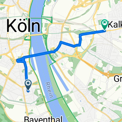
Köln_Linz am Rhein
Un itinéraire vélo au départ de Bayenthal, Rhénanie du Nord-Westphalie, Allemagne.
Vue d'ensemble
À propos du circuit
Cologne_Linz am Rhein
Longueur : 60 km Départ Chokoladenmuseum 9h30- -:--
 - Durée
 - 58,1 km
 - Distance
 - 159 m
 - Montée
 - 147 m
 - Descente
 - ---
 - Vit. moyenne
 - 76 m
 - Altitude max.
 
Qualité de l’itinéraire
Types de voies et surfaces le long de l’itinéraire
Types de routes
Sentier
31,4 km
(54 %)
Route tranquille
9,3 km
(16 %)
surfaces
Pavé
46,5 km
(80 %)
Non pavé
0,6 km
(1 %)
Asphalte
46,5 km
(80 %)
Gravier meuble
0,6 km
(1 %)
Indéfini
11 km
(19 %)
Points forts de l’itinéraire
Points d’intérêt le long de l’itinéraire

Photo après 0 km
Aggripinawerft

Photo après 3,3 km
Köln-Rodenkirchen

Photo après 6,4 km
Weißer Unterkölnweg

Photo après 9,6 km
Rheinufer, Sürth

Photo après 17,3 km
Leinpfad am Rhein

Photo après 25,8 km
Eschenallee am Rhein

Photo après 33,6 km
Bonn, Villa Hammerschmidt

Photo après 38,2 km
BONN : Gebäude der UNO

Photo après 44,6 km
Rolandswerth mit Blick auf den Drachenfels

Photo après 47,2 km
Oberwinter - Regenfänger

Photo après 51,1 km
Wallfahrtskirche Sankt Apollinaris

Photo après 53,5 km
Brücke von Remagen

Point d'intérêt après 56,6 km
Fähre zwischen Remagen und Linz

Photo après 57,3 km
Markzplatz Linz am Rhein

Point d'intérêt après 58,1 km
Bahnhof Linz(Rhein)
Continuer avec Bikemap
Utilise, modifie ou télécharge cet itinéraire vélo
Tu veux parcourir Köln_Linz am Rhein ou l’adapter à ton propre voyage ? Voici ce que tu peux faire avec cet itinéraire Bikemap :
Fonctionnalités gratuites
- Enregistre cet itinéraire comme favori ou dans une collection
 - Copie et planifie ta propre version de cet itinéraire
 - Synchronise ton itinéraire avec Garmin ou Wahoo
 
Fonctionnalités Premium
Essai gratuit de 3 jours, ou paiement unique. En savoir plus sur Bikemap Premium.
- Navigue sur cet itinéraire sur iOS et Android
 - Exporter un fichier GPX / KML de cet itinéraire
 - Crée ton impression personnalisée (essaie-la gratuitement)
 - Télécharge cet itinéraire pour la navigation hors ligne
 
Découvre plus de fonctionnalités Premium.
Obtiens Bikemap PremiumDe notre communauté
Bayenthal : Autres itinéraires populaires qui commencent ici
Neukirchener Tour- Distance
 - 70,5 km
 - Montée
 - 239 m
 - Descente
 - 239 m
 - Emplacement
 - Bayenthal, Rhénanie du Nord-Westphalie, Allemagne
 
Köln-Ruhrtal und zurück 150 Km- Distance
 - 153,2 km
 - Montée
 - 737 m
 - Descente
 - 724 m
 - Emplacement
 - Bayenthal, Rhénanie du Nord-Westphalie, Allemagne
 
Köln_Süd - Bonn- Distance
 - 31,9 km
 - Montée
 - 23 m
 - Descente
 - 20 m
 - Emplacement
 - Bayenthal, Rhénanie du Nord-Westphalie, Allemagne
 
CCC-K #3 Bensberg Spitze- Distance
 - 62,6 km
 - Montée
 - 550 m
 - Descente
 - 553 m
 - Emplacement
 - Bayenthal, Rhénanie du Nord-Westphalie, Allemagne
 
Marienfeld 1/23- Distance
 - 50,1 km
 - Montée
 - 215 m
 - Descente
 - 217 m
 - Emplacement
 - Bayenthal, Rhénanie du Nord-Westphalie, Allemagne
 
Route in Köln- Distance
 - 39,3 km
 - Montée
 - 181 m
 - Descente
 - 180 m
 - Emplacement
 - Bayenthal, Rhénanie du Nord-Westphalie, Allemagne
 
Giro Del Gelato- Distance
 - 119,6 km
 - Montée
 - 412 m
 - Descente
 - 412 m
 - Emplacement
 - Bayenthal, Rhénanie du Nord-Westphalie, Allemagne
 
Fr., 03. 06. 2022 Flughafentour, Rückweg über Königsforst- Distance
 - 68,7 km
 - Montée
 - 542 m
 - Descente
 - 532 m
 - Emplacement
 - Bayenthal, Rhénanie du Nord-Westphalie, Allemagne
 
Ouvre-la dans l’app


