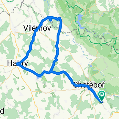
Ride to the Iron Mountains
Un itinéraire vélo au départ de Chotěboř, Kraj Vysočina, République tchèque.
Vue d'ensemble
À propos du circuit
Vous roulerez à la fois en forêt et sur la route. (environ moitié en forêt et moitié sur la route)
Il y a quelques sections de descente et aussi quelques montées...
C'est parfait pour une sortie du dimanche, mais vous y trouverez aussi beaucoup de plaisir à vélo.
- -:--
- Durée
- 44,1 km
- Distance
- 502 m
- Montée
- 503 m
- Descente
- ---
- Vit. moyenne
- ---
- Altitude max.
Qualité de l’itinéraire
Types de voies et surfaces le long de l’itinéraire
Types de routes
Route forestière
18,1 km
(41 %)
Route
12,3 km
(28 %)
surfaces
Pavé
16,3 km
(37 %)
Non pavé
13,2 km
(30 %)
Asphalte
12,8 km
(29 %)
Gravier
7,5 km
(17 %)
Points forts de l’itinéraire
Points d’intérêt le long de l’itinéraire

Point d'intérêt après 20,7 km
Lookout Tower
Point d'intérêt après 34,4 km
Nice bench by the pond to sit on and relax
Continuer avec Bikemap
Utilise, modifie ou télécharge cet itinéraire vélo
Tu veux parcourir Ride to the Iron Mountains ou l’adapter à ton propre voyage ? Voici ce que tu peux faire avec cet itinéraire Bikemap :
Fonctionnalités gratuites
- Enregistre cet itinéraire comme favori ou dans une collection
- Copie et planifie ta propre version de cet itinéraire
- Synchronise ton itinéraire avec Garmin ou Wahoo
Fonctionnalités Premium
Essai gratuit de 3 jours, ou paiement unique. En savoir plus sur Bikemap Premium.
- Navigue sur cet itinéraire sur iOS et Android
- Exporter un fichier GPX / KML de cet itinéraire
- Crée ton impression personnalisée (essaie-la gratuitement)
- Télécharge cet itinéraire pour la navigation hors ligne
Découvre plus de fonctionnalités Premium.
Obtiens Bikemap PremiumDe notre communauté
Chotěboř : Autres itinéraires populaires qui commencent ici
 Jarní výlet údolím pod Železnýma horama
- Distance
- 26,7 km
- Montée
- 292 m
- Descente
- 290 m
- Emplacement
- Chotěboř, Kraj Vysočina, République tchèque
 kopcovitý terén
- Distance
- 23,8 km
- Montée
- 385 m
- Descente
- 385 m
- Emplacement
- Chotěboř, Kraj Vysočina, République tchèque
 Výlet Chotěboř - pařížovská přehrada a zpět
- Distance
- 59,9 km
- Montée
- 417 m
- Descente
- 417 m
- Emplacement
- Chotěboř, Kraj Vysočina, République tchèque
 Libice - Boika
- Distance
- 41,1 km
- Montée
- 641 m
- Descente
- 641 m
- Emplacement
- Chotěboř, Kraj Vysočina, République tchèque
 Školní výlet 2
- Distance
- 21,8 km
- Montée
- 283 m
- Descente
- 265 m
- Emplacement
- Chotěboř, Kraj Vysočina, République tchèque
 Chotěboř - Lichnice- Lipnice nad Sázavou Chotěboř
- Distance
- 101 km
- Montée
- 843 m
- Descente
- 840 m
- Emplacement
- Chotěboř, Kraj Vysočina, République tchèque
 Ride to the Iron Mountains
- Distance
- 44,1 km
- Montée
- 502 m
- Descente
- 503 m
- Emplacement
- Chotěboř, Kraj Vysočina, République tchèque
 2015_11 Údolí Doubravy pěšky
- Distance
- 11,2 km
- Montée
- 169 m
- Descente
- 172 m
- Emplacement
- Chotěboř, Kraj Vysočina, République tchèque
Ouvre-la dans l’app


