

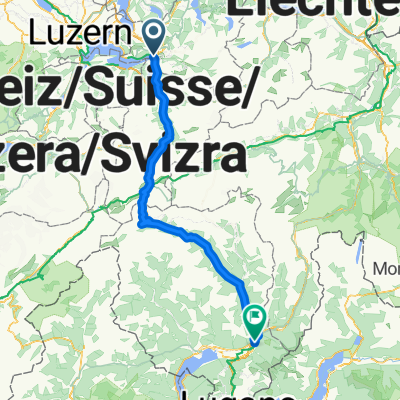
Umrundung Vierwaldstättersee
Un itinéraire vélo au départ de Ingenbohl, Canton of Schwyz, Switzerland.
Vue d'ensemble
À propos du circuit
104km_1640hm
- -:--
- Durée
- 104,2 km
- Distance
- 1 066 m
- Montée
- 1 063 m
- Descente
- ---
- Vit. moyenne
- ---
- Altitude max.

Qualité de l’itinéraire
Types de voies et surfaces le long de l’itinéraire
Types de routes
Route fréquentée
33,4 km
(32 %)
Route tranquille
23,7 km
(23 %)
surfaces
Pavé
70,7 km
(68 %)
Non pavé
7,9 km
(8 %)
Asphalte
67,6 km
(65 %)
Gravier
4,9 km
(5 %)
Continuer avec Bikemap
Utilise, modifie ou télécharge cet itinéraire vélo
Tu veux parcourir Umrundung Vierwaldstättersee ou l’adapter à ton propre voyage ? Voici ce que tu peux faire avec cet itinéraire Bikemap :
Fonctionnalités gratuites
- Enregistre cet itinéraire comme favori ou dans une collection
- Copie et planifie ta propre version de cet itinéraire
- Divise-le en étapes pour créer un tour sur plusieurs jours
- Synchronise ton itinéraire avec Garmin ou Wahoo
Fonctionnalités Premium
Essai gratuit de 3 jours, ou paiement unique. En savoir plus sur Bikemap Premium.
- Navigue sur cet itinéraire sur iOS et Android
- Exporter un fichier GPX / KML de cet itinéraire
- Crée ton impression personnalisée (essaie-la gratuitement)
- Télécharge cet itinéraire pour la navigation hors ligne
Découvre plus de fonctionnalités Premium.
Obtiens Bikemap PremiumDe notre communauté
Ingenbohl : Autres itinéraires populaires qui commencent ici
 3 Sachseln
- Distance
- 65,2 km
- Montée
- 1 906 m
- Descente
- 1 867 m
- Emplacement
- Ingenbohl, Canton of Schwyz, Switzerland
 Stoos
Stoos- Distance
- 31,7 km
- Montée
- 1 377 m
- Descente
- 1 376 m
- Emplacement
- Ingenbohl, Canton of Schwyz, Switzerland
 around rigi
- Distance
- 48,8 km
- Montée
- 323 m
- Descente
- 323 m
- Emplacement
- Ingenbohl, Canton of Schwyz, Switzerland
 Chätt
Chätt- Distance
- 29,5 km
- Montée
- 761 m
- Descente
- 763 m
- Emplacement
- Ingenbohl, Canton of Schwyz, Switzerland
 Wylenstrasse 11, Brunnen nach Wylenstrasse 9, Brunnen
- Distance
- 49,9 km
- Montée
- 500 m
- Descente
- 500 m
- Emplacement
- Ingenbohl, Canton of Schwyz, Switzerland
 1. Etappe Brunnen - Genova
- Distance
- 133,8 km
- Montée
- 1 856 m
- Descente
- 2 066 m
- Emplacement
- Ingenbohl, Canton of Schwyz, Switzerland
 Rundweg Seelisberg - Volligen
- Distance
- 4,1 km
- Montée
- 292 m
- Descente
- 293 m
- Emplacement
- Ingenbohl, Canton of Schwyz, Switzerland
 Lauerzersee-Rundfahrt 2
- Distance
- 19,6 km
- Montée
- 132 m
- Descente
- 126 m
- Emplacement
- Ingenbohl, Canton of Schwyz, Switzerland
Ouvre-la dans l’app