

B2B00248 55125>55112 viaRadio/Inwood/Ideal/OlsonLk/Demontr/WarnerRd/Lake/BaldEag/H2/Centv/CtyJ
Un itinéraire vélo au départ de Woodbury, Minnesota, États Unis.
Vue d'ensemble
À propos du circuit
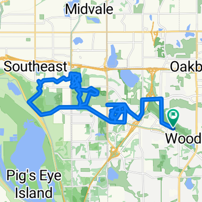
Nord sur Radio Dr. Cela devient Inwood Av. Suivez Inwood jusqu'à Stillwater Rd. Tournez à gauche et allez à Ideal. Tournez à droite et suivez Ideal vers le nord. Cela devient Olson Lake Rd. À 50th St. tournez à droite vers Demontreville Trail. Suivez Demontreville à gauche autour du lac jusqu'à Highlands Trail N. en haut de la colline. En haut de la colline, tournez à gauche à Hytrail Av. N. Sur votre gauche se trouve l'entrée du Gateway Trail. Prenez le chemin en bas de la colline et à travers une petite forêt. Il se courbe et soudain vous êtes à l'entrée du Gateway. Tournez à droite et passez par le tunnel sous l'autoroute 36. Juste après la fin du tunnel, il y a un virage en épingle à cheveux à gauche vers un parking et vers 60th St. N. À la fin de cette route se trouve Hilton Trail. Tournez à droite et allez au prochain coin et tournez à gauche à 62nd St. N. Allez à Warner Rd. et tournez à droite. Suivez Warner Av. vers le nord après Stillwater Rd. jusqu'à ce que vous atteigniez Locust St. Tournez à gauche vers Mahtomedi Av./244. Tournez à droite à Mahtomedi et suivez autour de White Bear Lake en passant par le Yacht Club jusqu'à ce que vous atteigniez Highway 96/LakeAv. Tournez à gauche et suivez jusqu'à ce que vous atteigniez Northwest Av. Angle à droite sur Northwest Av. jusqu'à ce que vous atteigniez Buffalo St. Tournez à gauche et traversez l'autoroute 61. Juste après les voies ferrées, tournez à gauche dans Hugo Rd. Suivez Hugo Rd. jusqu'à ce qu'elle se courbe à droite et devienne Park Av. Suivez Park Av. jusqu'à Bald Eagle Lake. Tournez à gauche sur Bald Eagle Blvd et faites le tour du lac jusqu'à ce que vous atteigniez Cty. Rd. H2. Tournez à gauche sur H2 et allez vers l'ouest jusqu'à ce que vous atteigniez Centerville Rd. Tournez à droite sur Centerville Rd. et allez vers le nord jusqu'à ce que vous atteigniez Cty Rd. J. sur la gauche. Tournez à gauche sur Cty J et continuez sur J vers l'ouest, passé Hodgson Rd./Lexington Av. et 35W. Continuez jusqu'à ce que vous atteigniez Coral Sea St. Tournez à gauche vers votre destination.
- -:--
- Durée
- 43,7 km
- Distance
- 134 m
- Montée
- 164 m
- Descente
- ---
- Vit. moyenne
- 319 m
- Altitude max.
Qualité de l’itinéraire
Types de voies et surfaces le long de l’itinéraire
Types de routes
Route
22,3 km
(51 %)
Piste cyclable
8,3 km
(19 %)
surfaces
Pavé
33,2 km
(76 %)
Asphalte
32,8 km
(75 %)
Pavé (non défini)
0,4 km
(1 %)
Indéfini
10,5 km
(24 %)
Continuer avec Bikemap
Utilise, modifie ou télécharge cet itinéraire vélo
Tu veux parcourir B2B00248 55125>55112 viaRadio/Inwood/Ideal/OlsonLk/Demontr/WarnerRd/Lake/BaldEag/H2/Centv/CtyJ ou l’adapter à ton propre voyage ? Voici ce que tu peux faire avec cet itinéraire Bikemap :
Fonctionnalités gratuites
- Enregistre cet itinéraire comme favori ou dans une collection
- Copie et planifie ta propre version de cet itinéraire
- Synchronise ton itinéraire avec Garmin ou Wahoo
Fonctionnalités Premium
Essai gratuit de 3 jours, ou paiement unique. En savoir plus sur Bikemap Premium.
- Navigue sur cet itinéraire sur iOS et Android
- Exporter un fichier GPX / KML de cet itinéraire
- Crée ton impression personnalisée (essaie-la gratuitement)
- Télécharge cet itinéraire pour la navigation hors ligne
Découvre plus de fonctionnalités Premium.
Obtiens Bikemap PremiumDe notre communauté
Woodbury : Autres itinéraires populaires qui commencent ici
 IronMAN Relay Route
- Distance
- 36,2 km
- Montée
- 190 m
- Descente
- 190 m
- Emplacement
- Woodbury, Minnesota, États Unis
 West to Battle Creek Park Ravine and back
- Distance
- 34,2 km
- Montée
- 265 m
- Descente
- 265 m
- Emplacement
- Woodbury, Minnesota, États Unis
 B2B00770 55125>55101 via Upper Afton Rd, E 6th St
- Distance
- 15,6 km
- Montée
- 81 m
- Descente
- 158 m
- Emplacement
- Woodbury, Minnesota, États Unis
 Lake Elmo Ride
- Distance
- 24,1 km
- Montée
- 113 m
- Descente
- 113 m
- Emplacement
- Woodbury, Minnesota, États Unis
 Slow ride in Woodbury
- Distance
- 7,8 km
- Montée
- 101 m
- Descente
- 106 m
- Emplacement
- Woodbury, Minnesota, États Unis
 South to Bailey Lake, Fairhaven, and beyond
- Distance
- 36,5 km
- Montée
- 241 m
- Descente
- 239 m
- Emplacement
- Woodbury, Minnesota, États Unis
 B2B00248 55125>55112 viaRadio/Inwood/Ideal/OlsonLk/Demontr/WarnerRd/Lake/BaldEag/H2/Centv/CtyJ
- Distance
- 43,7 km
- Montée
- 134 m
- Descente
- 164 m
- Emplacement
- Woodbury, Minnesota, États Unis
 10870 Ashley Ln, Woodbury to 10869 Ashley Ln, Woodbury
- Distance
- 28,9 km
- Montée
- 178 m
- Descente
- 177 m
- Emplacement
- Woodbury, Minnesota, États Unis
Ouvre-la dans l’app