

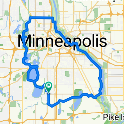
B2B00428 55406>55112 via46th/FordBridge/MissipBlvd/Pelham/Raymond/Como/Hamline/Lex
Un itinéraire vélo au départ de Richfield, Minnesota, États Unis.
Vue d'ensemble
À propos du circuit
Take 46th Street east to the Ford Bridge. After crossing the bridge turn immediately to the right and circle around under the bridge to go north on Mississippi Blvd. There is a bike path or the road.Take Mississippi Blvd. north past Summit and around the loop near St. Thomas. Continue on Mississippi under the LakeSt./Marshall Bridge.
At the next intersection turn right on to PelhamBlvd. and head up the hill past the Town & Country Golf course. Continue on over I94 to Myrtle Avenue. Turn right at Myrtle to Raymond Av. Turn left and continue on Raymond through S. St. Anthony Pk. to Como Av. Turn right at Como and continue on Como past the State Fair until you reach Hamline Av. Turn left at Hamline and continue on Hamline past Larpenteur, Cty. B1, B2, C. One block past Cty. C turn right on Woodhill Drive. Follow Woodhill Drive to Lexington. Turn left at Lexington and continue on Lexington past 694 to Cty. Rd. F. Turn left on F and follow to your destination.
- -:--
- Durée
- 23,3 km
- Distance
- 144 m
- Montée
- 108 m
- Descente
- ---
- Vit. moyenne
- 290 m
- Altitude max.
Qualité de l’itinéraire
Types de voies et surfaces le long de l’itinéraire
Types de routes
Route
11,5 km
(49 %)
Piste cyclable
5,9 km
(25 %)
surfaces
Pavé
16 km
(68 %)
Asphalte
13,4 km
(57 %)
Pavé (non défini)
1,3 km
(6 %)
Continuer avec Bikemap
Utilise, modifie ou télécharge cet itinéraire vélo
Tu veux parcourir B2B00428 55406>55112 via46th/FordBridge/MissipBlvd/Pelham/Raymond/Como/Hamline/Lex ou l’adapter à ton propre voyage ? Voici ce que tu peux faire avec cet itinéraire Bikemap :
Fonctionnalités gratuites
- Enregistre cet itinéraire comme favori ou dans une collection
- Copie et planifie ta propre version de cet itinéraire
- Synchronise ton itinéraire avec Garmin ou Wahoo
Fonctionnalités Premium
Essai gratuit de 3 jours, ou paiement unique. En savoir plus sur Bikemap Premium.
- Navigue sur cet itinéraire sur iOS et Android
- Exporter un fichier GPX / KML de cet itinéraire
- Crée ton impression personnalisée (essaie-la gratuitement)
- Télécharge cet itinéraire pour la navigation hors ligne
Découvre plus de fonctionnalités Premium.
Obtiens Bikemap PremiumDe notre communauté
Richfield : Autres itinéraires populaires qui commencent ici
 B2B00114 55409 >55414 via Park Ave and stone arch bridge
- Distance
- 9 km
- Montée
- 48 m
- Descente
- 57 m
- Emplacement
- Richfield, Minnesota, États Unis
 B2B00920 55407>55438 via Portland, Mnnha Pwy, Logan, Hylund Prk
- Distance
- 23,7 km
- Montée
- 98 m
- Descente
- 95 m
- Emplacement
- Richfield, Minnesota, États Unis
 B2B00001 55419 > 55416 via Lake Harriet, 38th, France
- Distance
- 8,4 km
- Montée
- 75 m
- Descente
- 76 m
- Emplacement
- Richfield, Minnesota, États Unis
 31 Miles South to North, to Victory Memorial & Minnehaha
- Distance
- 50,9 km
- Montée
- 124 m
- Descente
- 124 m
- Emplacement
- Richfield, Minnesota, États Unis
 30 miler
- Distance
- 48,5 km
- Montée
- 308 m
- Descente
- 310 m
- Emplacement
- Richfield, Minnesota, États Unis
 Perfect Circle Minneapolis Bike Route
- Distance
- 36,4 km
- Montée
- 117 m
- Descente
- 117 m
- Emplacement
- Richfield, Minnesota, États Unis
 East 46th Street 180, Minneapolis to Union Depot, Saint Paul
- Distance
- 22,2 km
- Montée
- 153 m
- Descente
- 185 m
- Emplacement
- Richfield, Minnesota, États Unis
 the Bike & Bistro's premiere tour
- Distance
- 6,7 km
- Montée
- 26 m
- Descente
- 9 m
- Emplacement
- Richfield, Minnesota, États Unis
Ouvre-la dans l’app