

River Ramble 20
Un itinéraire vélo au départ de Saint Paul, Minnesota, États Unis.
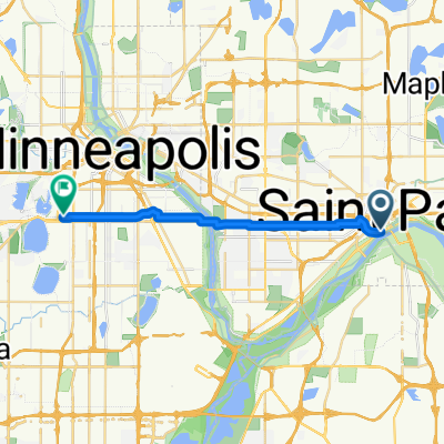
Vue d'ensemble
À propos du circuit
~20 miles le long du Mississippi.
Le trajet aller emprunte des sentiers le long des routes Shepard et Warner, jusqu'à Upper Afton Road. Nous tournerions vers le sud en traversant Battle Creek Park et emprunterions des routes assez calmes le long de la Hwy 61/10 jusqu'au franchissement du fleuve Mississippi à I-494.
Nous retournerions vers le nord via les sentiers MRT près du fleuve, en passant par Kaposia Landing, puis en empruntant la route Concord-Cesar Chavez-Wabasha à travers le centre-ville jusqu'au bâtiment des Transports.
- -:--
- Durée
- 29,6 km
- Distance
- 196 m
- Montée
- 197 m
- Descente
- ---
- Vit. moyenne
- ---
- Altitude max.
Qualité de l’itinéraire
Types de voies et surfaces le long de l’itinéraire
Types de routes
Piste cyclable
15,1 km
(51 %)
Route
5,3 km
(18 %)
surfaces
Pavé
24,6 km
(83 %)
Asphalte
16 km
(54 %)
Pavé (non défini)
6,5 km
(22 %)
Continuer avec Bikemap
Utilise, modifie ou télécharge cet itinéraire vélo
Tu veux parcourir River Ramble 20 ou l’adapter à ton propre voyage ? Voici ce que tu peux faire avec cet itinéraire Bikemap :
Fonctionnalités gratuites
- Enregistre cet itinéraire comme favori ou dans une collection
- Copie et planifie ta propre version de cet itinéraire
- Synchronise ton itinéraire avec Garmin ou Wahoo
Fonctionnalités Premium
Essai gratuit de 3 jours, ou paiement unique. En savoir plus sur Bikemap Premium.
- Navigue sur cet itinéraire sur iOS et Android
- Exporter un fichier GPX / KML de cet itinéraire
- Crée ton impression personnalisée (essaie-la gratuitement)
- Télécharge cet itinéraire pour la navigation hors ligne
Découvre plus de fonctionnalités Premium.
Obtiens Bikemap PremiumDe notre communauté
Saint Paul : Autres itinéraires populaires qui commencent ici
 Way to Church
- Distance
- 13,2 km
- Montée
- 54 m
- Descente
- 37 m
- Emplacement
- Saint Paul, Minnesota, États Unis
 B2B00024 55104 > 55121 via Big Rivers Trail
- Distance
- 16,8 km
- Montée
- 174 m
- Descente
- 174 m
- Emplacement
- Saint Paul, Minnesota, États Unis
 B2B00629 55102 < 55402 via Summit, River Road, West bank, Downtown
- Distance
- 15,5 km
- Montée
- 82 m
- Descente
- 94 m
- Emplacement
- Saint Paul, Minnesota, États Unis
 To the River Center
- Distance
- 17,1 km
- Montée
- 117 m
- Descente
- 90 m
- Emplacement
- Saint Paul, Minnesota, États Unis
 Jackson Street to East 7th Street
- Distance
- 1,6 km
- Montée
- 36 m
- Descente
- 0 m
- Emplacement
- Saint Paul, Minnesota, États Unis
 St Paul Gateway to: Brown’s creek to Stillwater and back .
- Distance
- 64,2 km
- Montée
- 408 m
- Descente
- 409 m
- Emplacement
- Saint Paul, Minnesota, États Unis
 B2B00062 55106 - 55075 via Concord, NURT
- Distance
- 9,5 km
- Montée
- 80 m
- Descente
- 110 m
- Emplacement
- Saint Paul, Minnesota, États Unis
 Gateway State Trail
- Distance
- 30 km
- Montée
- 115 m
- Descente
- 69 m
- Emplacement
- Saint Paul, Minnesota, États Unis
Ouvre-la dans l’app