

Stage 1
Un itinéraire vélo au départ de Palazzuolo sul Senio, Toscane, Italie.
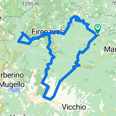
Vue d'ensemble
À propos du circuit
Une étape entre la vallée du Senio et celle de Sintria, avec des sections courtes et raides sur des routes étroites, une descente technique et des routes rugueuses souvent empruntées lors du Giro d'Italia. Nous passerons par Brisighella, un village de forteresses et de châteaux, considéré comme l'un des plus beaux endroits d'Italie. La troisième montée de la journée sera la célèbre la Valletta, une route très étroite qui grimpe le flanc de la montagne au milieu des cultures d'olives et de vignes, seulement 2,7 kilomètres, mais certainement très intense. Le dénivelé moyen d'environ 10 % avec des pics de 18-20 % fait de cette montée l'une des plus exigeantes de la région, également en raison des longs tronçons sans faux plats intermédiaires. Faites attention, la route étroite et les pentes importantes de 15-18 % rendent ces trois kilomètres difficiles même en descente. Une fois à Zattaglia, après quelques mètres sur une légère pente, commence immédiatement l'ascension du Monte Albano. (4,7 km avec un dénivelé moyen de 6 % - assez constant avec de longs tronçons à 7 % et deux pics légèrement au-dessus de 8 %.) Maintenant, il y a 5 km de descente rapide pour atteindre le pont sur le fleuve Senio à Casola Valsenio. De là, après quelques centaines de mètres, nous tournons à gauche sur la route Lavanda, un ascension de 5,6 km assez constante, avec des pentes toujours abordables et pratiquement jamais au-dessus de 8 %. Une chaussée suffisamment large avec de larges courbes, de grandes vues et une bonne vue sur le gisement de plâtre. Une fois à Prugno, une route étroite en montagne russe nous ramène à la route principale qui nous ramène à Palazzuolo.
- -:--
- Durée
- 92,4 km
- Distance
- 1 568 m
- Montée
- 1 568 m
- Descente
- ---
- Vit. moyenne
- ---
- Altitude max.

Qualité de l’itinéraire
Types de voies et surfaces le long de l’itinéraire
Types de routes
Route tranquille
28,6 km
(31 %)
Route
26,8 km
(29 %)
surfaces
Pavé
74,8 km
(81 %)
Non pavé
3,7 km
(4 %)
Asphalte
73,9 km
(80 %)
Gravier
2,8 km
(3 %)
Continuer avec Bikemap
Utilise, modifie ou télécharge cet itinéraire vélo
Tu veux parcourir Stage 1 ou l’adapter à ton propre voyage ? Voici ce que tu peux faire avec cet itinéraire Bikemap :
Fonctionnalités gratuites
- Enregistre cet itinéraire comme favori ou dans une collection
- Copie et planifie ta propre version de cet itinéraire
- Divise-le en étapes pour créer un tour sur plusieurs jours
- Synchronise ton itinéraire avec Garmin ou Wahoo
Fonctionnalités Premium
Essai gratuit de 3 jours, ou paiement unique. En savoir plus sur Bikemap Premium.
- Navigue sur cet itinéraire sur iOS et Android
- Exporter un fichier GPX / KML de cet itinéraire
- Crée ton impression personnalisée (essaie-la gratuitement)
- Télécharge cet itinéraire pour la navigation hors ligne
Découvre plus de fonctionnalités Premium.
Obtiens Bikemap PremiumDe notre communauté
Palazzuolo sul Senio : Autres itinéraires populaires qui commencent ici
 Stage 3
- Distance
- 115,9 km
- Montée
- 1 915 m
- Descente
- 1 933 m
- Emplacement
- Palazzuolo sul Senio, Toscane, Italie
 Palazzuolo-Marradi-Colla-Sambuca11/ago/2015
- Distance
- 47 km
- Montée
- 1 097 m
- Descente
- 1 102 m
- Emplacement
- Palazzuolo sul Senio, Toscane, Italie
 Palazzuolo - Passo Futa
- Distance
- 42,4 km
- Montée
- 1 070 m
- Descente
- 642 m
- Emplacement
- Palazzuolo sul Senio, Toscane, Italie
 Palazzuolo-Sambuca-Marradi-Carnevale
- Distance
- 47,4 km
- Montée
- 1 109 m
- Descente
- 1 107 m
- Emplacement
- Palazzuolo sul Senio, Toscane, Italie
 Stage 4
- Distance
- 45,1 km
- Montée
- 1 144 m
- Descente
- 1 147 m
- Emplacement
- Palazzuolo sul Senio, Toscane, Italie
 Quattro passi del mugello
- Distance
- 118,4 km
- Montée
- 2 338 m
- Descente
- 2 337 m
- Emplacement
- Palazzuolo sul Senio, Toscane, Italie
 Palazzuolo-Marradi-Sambuca-Palazzuolo
- Distance
- 46,7 km
- Montée
- 1 112 m
- Descente
- 1 123 m
- Emplacement
- Palazzuolo sul Senio, Toscane, Italie
 Palazzuolo-Marradi-Colla-Sambuca08/ago/2015
- Distance
- 46,7 km
- Montée
- 1 101 m
- Descente
- 1 105 m
- Emplacement
- Palazzuolo sul Senio, Toscane, Italie
Ouvre-la dans l’app