

Circumnavigate Edmonds Bay/Stoney Creek
Un itinéraire vélo au départ de Fennell Bay, Nouvelle-Galles du Sud, Australie.
Vue d'ensemble
À propos du circuit
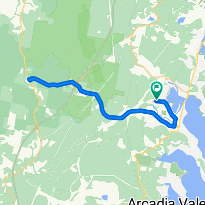
Leave Blackalls Park Public School from its entrance at the corner of Rupert and Todd Streets travelling NE on Rupert.
At the corner of Rupert St and South Parade, carefully cross diagonally into Rose Street (East) and travel the 100m to the Greenway-Cycleway.
Follow the Greenway-Cycleway north to Fassifern township. At the junction for Fassifern Railway Station, travel east a few metres and enter Awaba Street.
On Awaba Street, travel north and cross the bridge into Bridge Street, Fassifern and travel NW onto the intersection with Macquarie Road.
Turn right onto Macquarie Road and travel about 1.5km to Brougham Ave ((generally SE most of the way).
Turn right down Brougham Ave (south) and turn left into Edwards Street ... carefully negotiating FIVE cross-streets until joining the Main Road over Fennell Bay Bridge and 1200 metres to Day Street.
Turn Left at Day street and go 50 m sweeping gently onto Renwick Street.It's just under 600m to a right turn into Bay Street passing McDonald's Toronto as you get back to the Main Road.
Safely cross the Main Road at the lights and then go 100m SOUTH to the Greenway-Cycleway entry point opposite the Victory Parade intersection.
Stay on the Greenway about 1750 metres (travelling generally NORTH-WEST) until you see the exit path for Todd Street.
Carefully cross the Main Road the travel west on Todd Street the 400 metres to where we started this route.
- -:--
- Durée
- 9,2 km
- Distance
- 54 m
- Montée
- 63 m
- Descente
- ---
- Vit. moyenne
- ---
- Altitude max.

Continuer avec Bikemap
Utilise, modifie ou télécharge cet itinéraire vélo
Tu veux parcourir Circumnavigate Edmonds Bay/Stoney Creek ou l’adapter à ton propre voyage ? Voici ce que tu peux faire avec cet itinéraire Bikemap :
Fonctionnalités gratuites
- Enregistre cet itinéraire comme favori ou dans une collection
- Copie et planifie ta propre version de cet itinéraire
- Synchronise ton itinéraire avec Garmin ou Wahoo
Fonctionnalités Premium
Essai gratuit de 3 jours, ou paiement unique. En savoir plus sur Bikemap Premium.
- Navigue sur cet itinéraire sur iOS et Android
- Exporter un fichier GPX / KML de cet itinéraire
- Crée ton impression personnalisée (essaie-la gratuitement)
- Télécharge cet itinéraire pour la navigation hors ligne
Découvre plus de fonctionnalités Premium.
Obtiens Bikemap PremiumDe notre communauté
Fennell Bay : Autres itinéraires populaires qui commencent ici
 Another Local Suburban Exercise Course
- Distance
- 11,9 km
- Montée
- 83 m
- Descente
- 86 m
- Emplacement
- Fennell Bay, Nouvelle-Galles du Sud, Australie
 Blackalls Park Public School to Toronto Pool +
- Distance
- 10,5 km
- Montée
- 67 m
- Descente
- 66 m
- Emplacement
- Fennell Bay, Nouvelle-Galles du Sud, Australie
 Around Fennell Bay & connected suburbs
- Distance
- 13,2 km
- Montée
- 82 m
- Descente
- 94 m
- Emplacement
- Fennell Bay, Nouvelle-Galles du Sud, Australie
 Lapped Fennell Bay & Edmunds Bay + Toronto Shops
- Distance
- 11,2 km
- Montée
- 87 m
- Descente
- 85 m
- Emplacement
- Fennell Bay, Nouvelle-Galles du Sud, Australie
 Toronto High School, Coles, home
- Distance
- 16,7 km
- Montée
- 84 m
- Descente
- 88 m
- Emplacement
- Fennell Bay, Nouvelle-Galles du Sud, Australie
 Blackalls Park - THS - Toronto - home - 10.5km
- Distance
- 10,7 km
- Montée
- 81 m
- Descente
- 80 m
- Emplacement
- Fennell Bay, Nouvelle-Galles du Sud, Australie
 Circumnavigate Edmonds Bay/Stoney Creek
- Distance
- 9,2 km
- Montée
- 54 m
- Descente
- 63 m
- Emplacement
- Fennell Bay, Nouvelle-Galles du Sud, Australie
 BPPS to Freemans Waterhole Subway
- Distance
- 28,6 km
- Montée
- 197 m
- Descente
- 197 m
- Emplacement
- Fennell Bay, Nouvelle-Galles du Sud, Australie
Ouvre-la dans l’app