

Around Fennell Bay & connected suburbs
Un itinéraire vélo au départ de Fennell Bay, Nouvelle-Galles du Sud, Australie.
Vue d'ensemble
À propos du circuit
-
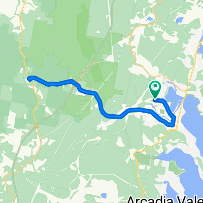
To Toronto via Greenway-Cycleway. Pick up coffee in The Boulevard.
-
Back past Toronto Railway Station, the Royal Motor Yacht Club, Toronto Public School THEN via Renwick Street to Toronto Lions' Club Park.
-
Cross Fennell Bay Bridge (travelling north) then walk your bike across the Main Road to Ottey's Lane.
-
Travel in streets parallel to the Fennell Bay waterfront to Brougham Avenue. Right Turn (Brougham Ave) then Left Turn into Macquarie Road.
-
Travel about 1.42km and access the bush track off the access lane to Fassifern Rsail Station. Turn east onto the Greenway-Cycleway and travel to Blackalls Park.
-
Utilise the path that links The Greenway-Cycleway to North Parade. Travel 320m south-east on North Parade.
-
Turn right onto Faucett THEN quickly LEFT onto Railway Parade ... After 220m, execute a RIGHT turn into Adam Street, a RIGHT into Fennell Crescent, a RIGHT into Faucett Street and a LEFT onto Railway Parade.
-
At the liquor store & Chinese Restaurant, turn left into Centre Avenue. Then a minor kink into Rhodes Street, a LEFT into Charles Street, a RIGHT into Faucett Street THEN a final RIGHT into Rupert Street.
-
Travel just 120 metres downhill THEN swing LEFT into the Todd Street cul-de-sac. You are now less than 80 metres from your original starting point.
WELL DONE!
- -:--
- Durée
- 13,2 km
- Distance
- 82 m
- Montée
- 94 m
- Descente
- ---
- Vit. moyenne
- ---
- Altitude max.

Continuer avec Bikemap
Utilise, modifie ou télécharge cet itinéraire vélo
Tu veux parcourir Around Fennell Bay & connected suburbs ou l’adapter à ton propre voyage ? Voici ce que tu peux faire avec cet itinéraire Bikemap :
Fonctionnalités gratuites
- Enregistre cet itinéraire comme favori ou dans une collection
- Copie et planifie ta propre version de cet itinéraire
- Synchronise ton itinéraire avec Garmin ou Wahoo
Fonctionnalités Premium
Essai gratuit de 3 jours, ou paiement unique. En savoir plus sur Bikemap Premium.
- Navigue sur cet itinéraire sur iOS et Android
- Exporter un fichier GPX / KML de cet itinéraire
- Crée ton impression personnalisée (essaie-la gratuitement)
- Télécharge cet itinéraire pour la navigation hors ligne
Découvre plus de fonctionnalités Premium.
Obtiens Bikemap PremiumDe notre communauté
Fennell Bay : Autres itinéraires populaires qui commencent ici
 BPPS to Freemans Waterhole Subway
- Distance
- 28,6 km
- Montée
- 197 m
- Descente
- 197 m
- Emplacement
- Fennell Bay, Nouvelle-Galles du Sud, Australie
 Blackalls Park to North Toronto Industrial Estate then home through Fassifern
- Distance
- 8,5 km
- Montée
- 74 m
- Descente
- 48 m
- Emplacement
- Fennell Bay, Nouvelle-Galles du Sud, Australie
 Bay Lap and Lunch at McCafe TOR
- Distance
- 13 km
- Montée
- 84 m
- Descente
- 81 m
- Emplacement
- Fennell Bay, Nouvelle-Galles du Sud, Australie
 Lapped Fennell Bay & Edmunds Bay + Toronto Shops
- Distance
- 11,2 km
- Montée
- 87 m
- Descente
- 85 m
- Emplacement
- Fennell Bay, Nouvelle-Galles du Sud, Australie
 Toronto Pool (short) + Back Home (long)
- Distance
- 12,1 km
- Montée
- 109 m
- Descente
- 106 m
- Emplacement
- Fennell Bay, Nouvelle-Galles du Sud, Australie
 Blackalls Park Public School to Toronto Pool +
- Distance
- 10,5 km
- Montée
- 67 m
- Descente
- 66 m
- Emplacement
- Fennell Bay, Nouvelle-Galles du Sud, Australie
 Blackalls Park - THS - Toronto - home - 10.5km
- Distance
- 10,7 km
- Montée
- 81 m
- Descente
- 80 m
- Emplacement
- Fennell Bay, Nouvelle-Galles du Sud, Australie
 Toronto High School, Coles, home
- Distance
- 16,7 km
- Montée
- 84 m
- Descente
- 88 m
- Emplacement
- Fennell Bay, Nouvelle-Galles du Sud, Australie
Ouvre-la dans l’app