

Tour at Forcella Lerosa
Un itinéraire vélo au départ de Cortina d'Ampezzo, Vénétie, Italie.
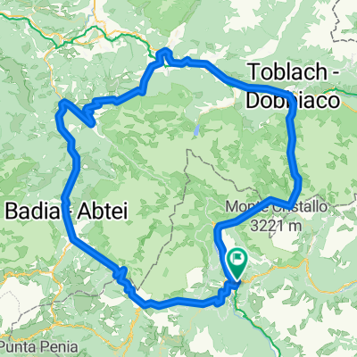
Vue d'ensemble
À propos du circuit
Description from ”Mountain biking in the Dolomites” book (Mauro Tumler):
For those intending to spend a longer holiday in the Dolomites, this tour is an ideal cycling introduction to the area. Most of the tour runs on the meticulously sign-posted Cortina–Dobbiaco cycle route, while the steep climb on technical terrain to the Forcella Lerosa requires a good amount of stamina. Reward is a nice single-track section with tight switchbacks from the Forcella to the Malga Ra Stua.
DIRECTIONS
Just the landscape is reason enough to get out on a bike. even the physical effort is contained with an 810 metres climb. this tour derives its name from the Forcella Lerosa, located on a high altitude alp at the beginning of the Val de Gotres. A little wooden cross commemorates an Austrian military cemetery from the Big War. the Forcella Lerosa is a popular passage for cyclists to get to Marebbe in Alto Adige, riding through the Val Salata and the Rifugio Sennes.
Itinerary description
From ➊ cortina bus station (1220 m) take the sign-posted bicycle path in the direction of Dobbiaco; 1 km before the Passo di cima Banche cross the ➋ SS 51 and follow directions to Val di Gotres, and then take MtB route n. 10 to the ➌ Forcella Lerosa (2020 m). continue to ➍ Monte de Lerosa (1995 m) and from here to the left start descending on switchbacks ➎ to the Malga Ra Stua (1668 m, food available). continue on paved road to arrive at the ➏ S. Uberto car park (1449 m), and then on ➐ the village of Felizòn (1005 m), eventually riding past the ➑ Fiàmes hotel. At the camping olympia get back onto the road, cross it, and return to the starting point along the bicycle path.
Sign-posted MtB route N. 10
STARTING POINT
Cortina, 1220 m
TARGET POINT
Cortina, 1220 m
- -:--
- Durée
- 31,8 km
- Distance
- 821 m
- Montée
- 822 m
- Descente
- ---
- Vit. moyenne
- ---
- Altitude max.

Qualité de l’itinéraire
Types de voies et surfaces le long de l’itinéraire
Types de routes
Piste cyclable
15,3 km
(48 %)
Route forestière
7,8 km
(24 %)
surfaces
Pavé
11,5 km
(36 %)
Non pavé
19,7 km
(62 %)
Gravier
15,4 km
(49 %)
Asphalte
11,2 km
(35 %)
Continuer avec Bikemap
Utilise, modifie ou télécharge cet itinéraire vélo
Tu veux parcourir Tour at Forcella Lerosa ou l’adapter à ton propre voyage ? Voici ce que tu peux faire avec cet itinéraire Bikemap :
Fonctionnalités gratuites
- Enregistre cet itinéraire comme favori ou dans une collection
- Copie et planifie ta propre version de cet itinéraire
- Synchronise ton itinéraire avec Garmin ou Wahoo
Fonctionnalités Premium
Essai gratuit de 3 jours, ou paiement unique. En savoir plus sur Bikemap Premium.
- Navigue sur cet itinéraire sur iOS et Android
- Exporter un fichier GPX / KML de cet itinéraire
- Crée ton impression personnalisée (essaie-la gratuitement)
- Télécharge cet itinéraire pour la navigation hors ligne
Découvre plus de fonctionnalités Premium.
Obtiens Bikemap PremiumDe notre communauté
Cortina d'Ampezzo : Autres itinéraires populaires qui commencent ici
 Olympia camp - Cinque torri - P. So. giau. Olympia camp
- Distance
- 44,1 km
- Montée
- 1 715 m
- Descente
- 1 715 m
- Emplacement
- Cortina d'Ampezzo, Vénétie, Italie
 Cortina … San Candido
- Distance
- 76 km
- Montée
- 1 018 m
- Descente
- 1 014 m
- Emplacement
- Cortina d'Ampezzo, Vénétie, Italie
 Cortina d`Ampezzo - Toblach MTB Marathon
- Distance
- 43,5 km
- Montée
- 573 m
- Descente
- 575 m
- Emplacement
- Cortina d'Ampezzo, Vénétie, Italie
 Cortina P. Furcia, Cimabanche
- Distance
- 121,2 km
- Montée
- 2 206 m
- Descente
- 2 203 m
- Emplacement
- Cortina d'Ampezzo, Vénétie, Italie
 2020-09-02 18:34:14Cortina-Belluno
- Distance
- 75,2 km
- Montée
- 1 096 m
- Descente
- 1 917 m
- Emplacement
- Cortina d'Ampezzo, Vénétie, Italie
 Dol 3 Zinnen
- Distance
- 16,1 km
- Montée
- 738 m
- Descente
- 739 m
- Emplacement
- Cortina d'Ampezzo, Vénétie, Italie
 cortina giro dei sette rifugi
- Distance
- 57,2 km
- Montée
- 1 917 m
- Descente
- 1 917 m
- Emplacement
- Cortina d'Ampezzo, Vénétie, Italie
 5 Rifugi
- Distance
- 31,6 km
- Montée
- 1 404 m
- Descente
- 1 404 m
- Emplacement
- Cortina d'Ampezzo, Vénétie, Italie
Ouvre-la dans l’app