

Schwarzee über St.Johann auf den Harschbichl
Un itinéraire vélo au départ de Reith bei Kitzbühel, Tyrol, Autriche.
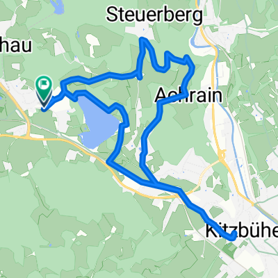
Vue d'ensemble
À propos du circuit
- -:--
- Durée
- 31,2 km
- Distance
- 1 042 m
- Montée
- 1 036 m
- Descente
- ---
- Vit. moyenne
- ---
- Altitude max.
Continuer avec Bikemap
Utilise, modifie ou télécharge cet itinéraire vélo
Tu veux parcourir Schwarzee über St.Johann auf den Harschbichl ou l’adapter à ton propre voyage ? Voici ce que tu peux faire avec cet itinéraire Bikemap :
Fonctionnalités gratuites
- Enregistre cet itinéraire comme favori ou dans une collection
- Copie et planifie ta propre version de cet itinéraire
- Synchronise ton itinéraire avec Garmin ou Wahoo
Fonctionnalités Premium
Essai gratuit de 3 jours, ou paiement unique. En savoir plus sur Bikemap Premium.
- Navigue sur cet itinéraire sur iOS et Android
- Exporter un fichier GPX / KML de cet itinéraire
- Crée ton impression personnalisée (essaie-la gratuitement)
- Télécharge cet itinéraire pour la navigation hors ligne
Découvre plus de fonctionnalités Premium.
Obtiens Bikemap PremiumDe notre communauté
Reith bei Kitzbühel : Autres itinéraires populaires qui commencent ici
 Schwarzee über St.Johann auf den Harschbichl
- Distance
- 31,2 km
- Montée
- 1 042 m
- Descente
- 1 036 m
- Emplacement
- Reith bei Kitzbühel, Tyrol, Autriche
 Kitzbühel
- Distance
- 9,4 km
- Montée
- 125 m
- Descente
- 124 m
- Emplacement
- Reith bei Kitzbühel, Tyrol, Autriche
 Reith-Astberg-Ellmau-Oberndorf-Kitzbühel-Kitzbüheler Horn-Kitzbühel-Münichau-Reith
- Distance
- 54,5 km
- Montée
- 1 853 m
- Descente
- 1 853 m
- Emplacement
- Reith bei Kitzbühel, Tyrol, Autriche
 ITU Kitzbuhel 2012
- Distance
- 12,3 km
- Montée
- 992 m
- Descente
- 91 m
- Emplacement
- Reith bei Kitzbühel, Tyrol, Autriche
 Der Weg zum Ochsen
- Distance
- 22,5 km
- Montée
- 755 m
- Descente
- 667 m
- Emplacement
- Reith bei Kitzbühel, Tyrol, Autriche
 reith bei kitzbühel waidring steinplatte winklmoosalm reith im winkl reith bei kitzbühel
- Distance
- 86,4 km
- Montée
- 1 531 m
- Descente
- 1 527 m
- Emplacement
- Reith bei Kitzbühel, Tyrol, Autriche
 Rund um den Astberg
- Distance
- 18,5 km
- Montée
- 674 m
- Descente
- 676 m
- Emplacement
- Reith bei Kitzbühel, Tyrol, Autriche
 Rund um den Wilden Kaiser
- Distance
- 85,5 km
- Montée
- 527 m
- Descente
- 541 m
- Emplacement
- Reith bei Kitzbühel, Tyrol, Autriche
Ouvre-la dans l’app