
KIN-22L Spring 2020
2020-04-23 Bike Ride
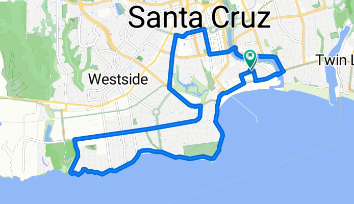
Un itinéraire vélo au départ de Santa Cruz, Californie, États Unis.
Vue d'ensemble
À propos du circuit
Un peu d'un itinéraire différent.
- -:--
- Durée
- 13,6 km
- Distance
- 38 m
- Montée
- 39 m
- Descente
- ---
- Vit. moyenne
- ---
- Altitude max.

Partie de
17 étapes
Qualité de l’itinéraire
Types de voies et surfaces le long de l’itinéraire
Types de routes
Piste cyclable
6,1 km
(45 %)
Route
2,6 km
(19 %)
surfaces
Pavé
11 km
(81 %)
Asphalte
9,2 km
(68 %)
Pavé (non défini)
1,2 km
(9 %)
Points forts de l’itinéraire
Points d’intérêt le long de l’itinéraire

Photo après 0 km
End of ride.

Photo après 0 km
Starting Point

Photo après 1,3 km
People happy to be surfing again

Photo après 2,5 km
Our rocky shoreline

Photo après 5,2 km
Turning onto Swanton

Photo après 5,7 km
Turning onto Delaware

Photo après 8,3 km
One of my favorite houses along the route.

Photo après 9,4 km
California and Acadia.

Photo après 10,1 km
Prior to starting this biking routine I did not know where this high school was located.

Photo après 10,6 km
Turning off of Walnut onto Center

Photo après 11,5 km
Getting on Riverwalk East.

Photo après 12,3 km
Every time I see people in the river it gives me the willies. I often see teams testing the water but I still shudder to think how dirty it is.

Photo après 13,3 km
They're using the moment to do some construction in there.
Continuer avec Bikemap
Utilise, modifie ou télécharge cet itinéraire vélo
Tu veux parcourir 2020-04-23 Bike Ride ou l’adapter à ton propre voyage ? Voici ce que tu peux faire avec cet itinéraire Bikemap :
Fonctionnalités gratuites
- Enregistre cet itinéraire comme favori ou dans une collection
- Copie et planifie ta propre version de cet itinéraire
- Synchronise ton itinéraire avec Garmin ou Wahoo
Fonctionnalités Premium
Essai gratuit de 3 jours, ou paiement unique. En savoir plus sur Bikemap Premium.
- Navigue sur cet itinéraire sur iOS et Android
- Exporter un fichier GPX / KML de cet itinéraire
- Crée ton impression personnalisée (essaie-la gratuitement)
- Télécharge cet itinéraire pour la navigation hors ligne
Découvre plus de fonctionnalités Premium.
Obtiens Bikemap PremiumDe notre communauté
Santa Cruz : Autres itinéraires populaires qui commencent ici
 2020-04-24 Bike Ride (In Reverse)
- Distance
- 14,5 km
- Montée
- 32 m
- Descente
- 31 m
- Emplacement
- Santa Cruz, Californie, États Unis
 2020-04-11 Bike Route 3
- Distance
- 13,9 km
- Montée
- 45 m
- Descente
- 47 m
- Emplacement
- Santa Cruz, Californie, États Unis
 2020-04-18 Bike Route
- Distance
- 14,8 km
- Montée
- 53 m
- Descente
- 53 m
- Emplacement
- Santa Cruz, Californie, États Unis
 2020-05-10 Bike Ride
- Distance
- 15 km
- Montée
- 52 m
- Descente
- 49 m
- Emplacement
- Santa Cruz, Californie, États Unis
 2020-04-10 Bike Ride
- Distance
- 10,9 km
- Montée
- 33 m
- Descente
- 36 m
- Emplacement
- Santa Cruz, Californie, États Unis
 2020-05-02 (Extended Route)
- Distance
- 17 km
- Montée
- 98 m
- Descente
- 98 m
- Emplacement
- Santa Cruz, Californie, États Unis
 2020-05-14 Bike Ride
- Distance
- 16,4 km
- Montée
- 85 m
- Descente
- 83 m
- Emplacement
- Santa Cruz, Californie, États Unis
 Branciforte-Old San Jose Rd.-East Cliff Drive
- Distance
- 40,6 km
- Montée
- 328 m
- Descente
- 328 m
- Emplacement
- Santa Cruz, Californie, États Unis
Ouvre-la dans l’app