

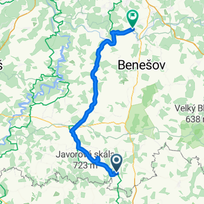
Jistebnický okruh
Un itinéraire vélo au départ de Jistebnice, Bohême-du-Sud, République tchèque.
Vue d'ensemble
À propos du circuit
Jistebnice – Nadějkov (piste cyclable 1175), Nadějkov – Milevsko (1059), Milevsko – Chyšky (route de 2e catégorie 105 puis 121), Chyšky – Sedlec-Prčice (piste cyclable 1154), Sedlec-Prčice – Cunkov (route de 3e catégorie via Jetřichovice), Cunkov – Jistebnice (piste cyclable 0074)
- -:--
- Durée
- 51 km
- Distance
- 661 m
- Montée
- 661 m
- Descente
- ---
- Vit. moyenne
- ---
- Altitude max.
Qualité de l’itinéraire
Types de voies et surfaces le long de l’itinéraire
Types de routes
Route
17,3 km
(34 %)
Route tranquille
2 km
(4 %)
Indéfini
31,6 km
(62 %)
surfaces
Pavé
5,1 km
(10 %)
Asphalte
5,1 km
(10 %)
Indéfini
45,9 km
(90 %)
Continuer avec Bikemap
Utilise, modifie ou télécharge cet itinéraire vélo
Tu veux parcourir Jistebnický okruh ou l’adapter à ton propre voyage ? Voici ce que tu peux faire avec cet itinéraire Bikemap :
Fonctionnalités gratuites
- Enregistre cet itinéraire comme favori ou dans une collection
- Copie et planifie ta propre version de cet itinéraire
- Synchronise ton itinéraire avec Garmin ou Wahoo
Fonctionnalités Premium
Essai gratuit de 3 jours, ou paiement unique. En savoir plus sur Bikemap Premium.
- Navigue sur cet itinéraire sur iOS et Android
- Exporter un fichier GPX / KML de cet itinéraire
- Crée ton impression personnalisée (essaie-la gratuitement)
- Télécharge cet itinéraire pour la navigation hors ligne
Découvre plus de fonctionnalités Premium.
Obtiens Bikemap PremiumDe notre communauté
Jistebnice : Autres itinéraires populaires qui commencent ici
 2012_Moninec-Pancir-Spicak
- Distance
- 171,1 km
- Montée
- 1 574 m
- Descente
- 1 350 m
- Emplacement
- Jistebnice, Bohême-du-Sud, République tchèque
 pokus
pokus- Distance
- 28,1 km
- Montée
- 319 m
- Descente
- 444 m
- Emplacement
- Jistebnice, Bohême-du-Sud, République tchèque
 Jistebnice - Pyšely
- Distance
- 57,1 km
- Montée
- 655 m
- Descente
- 977 m
- Emplacement
- Jistebnice, Bohême-du-Sud, République tchèque
 Jistebnický kancionál
- Distance
- 59,6 km
- Montée
- 721 m
- Descente
- 724 m
- Emplacement
- Jistebnice, Bohême-du-Sud, République tchèque
 Jistebnický kancionál - fitness jízda
- Distance
- 23,5 km
- Montée
- 445 m
- Descente
- 452 m
- Emplacement
- Jistebnice, Bohême-du-Sud, République tchèque
 Jistebnický okruh
- Distance
- 51 km
- Montée
- 661 m
- Descente
- 661 m
- Emplacement
- Jistebnice, Bohême-du-Sud, République tchèque
 Alenina Lhota to Tabor, Day 1
- Distance
- 42,3 km
- Montée
- 355 m
- Descente
- 528 m
- Emplacement
- Jistebnice, Bohême-du-Sud, République tchèque
 Strezimir
- Distance
- 29,6 km
- Montée
- 479 m
- Descente
- 467 m
- Emplacement
- Jistebnice, Bohême-du-Sud, République tchèque
Ouvre-la dans l’app