

Road cycling. Val d'Aran - Pyrenees: Tour Vielha with Superbagneres
Un itinéraire vélo au départ de Les, Catalogne, Espagne.
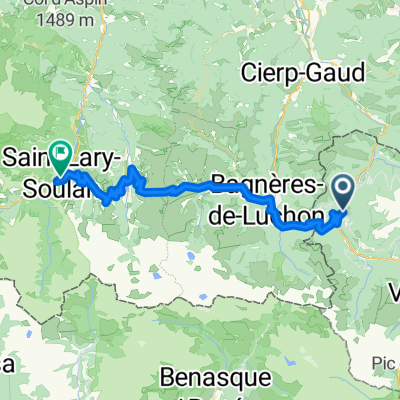
Vue d'ensemble
À propos du circuit
Cet itinéraire commence à Bossòst, mais il pourrait tout aussi bien convenir aux cyclistes séjournant à Vielha, qui pourraient rejoindre Bossòst en longeant les larges accotements de la N-230.
Nous partons de Bossòst en quittant la ville par le sud, le long de la rivière Garona, puis en montant, juste au rond-point, à droite, sur la N-141. C'est le début du Portilhon, le col qui marque la frontière entre l'Espagne et la France. Il commence par une série d'épingles à cheveux offrant une vue magnifique sur Bossòst, grimpe au-delà du parc Aran, et après avoir franchi la frontière au sommet, dévale rapidement en France.
À Saint-Mamet, si vous êtes en bonne forme, suivez la trace GPS à gauche après avoir traversé la rivière Pique, pour monter jusqu'à Superbagnères. Cette montée est une impasse, ce qui signifie que vous monterez au sommet et reviendrez à ce point. Donc, si vous préférez la laisser de côté, tournez à droite après avoir traversé la rivière Pique et continuez à travers Bagnères de Luchon.
Si vous décidez de monter à Superbagnères, la pente devient assez raide peu après Saint-Mamet, avec des passages à 12 % dans les deux premiers kilomètres. La montée totale fait 18,5 kilomètres et s'adresse aux cyclistes experts. Le gain d'altitude total est de 1170 m, ce qui vous amène à plus de 1800 m d'altitude, avec une pente moyenne de 6,3 %. Vous quitterez finalement la limite des arbres, et le paysage s'ouvre sur de vastes pâturages d'altitude, avec une vue sur de nombreux sommets enneigés de 3000 m dans la région. Une fois au sommet de la station de ski, il ne vous reste plus qu'à faire demi-tour et à profiter de la descente vers Bagnères-de-Luchon !
L'itinéraire traverse maintenant Bagnères-de-Luchon du sud au nord, puis suit la rivière Pique le long de la D125 jusqu'à Gaud, où nous tournons à droite au rond-point et rejoignons la D44 en direction de Marignac. La D44 est une route assez facile, qui monte très doucement après Marignac. Nous arrivons dans la vallée de la rivière Garonne et tournons à droite sur la N125, qui continue à monter doucement le long de la vallée, en direction de la frontière espagnole.
Points d'intérêt : La montée à Superbagnères est un pèlerinage pour les fans du Tour de France, qui ont assisté à nombreuses batailles célèbres entre les meilleurs cyclistes du monde sur ses rampes. C'est un endroit très sauvage, et il y a de belles vues (et sons) de la rivière Lys qui dévale le long de la route, le long de la route.
- -:--
- Durée
- 90,2 km
- Distance
- 2 386 m
- Montée
- 2 386 m
- Descente
- ---
- Vit. moyenne
- ---
- Altitude max.

Qualité de l’itinéraire
Types de voies et surfaces le long de l’itinéraire
Types de routes
Route
33,4 km
(37 %)
Route tranquille
1,8 km
(2 %)
surfaces
Pavé
46,9 km
(52 %)
Asphalte
46,9 km
(52 %)
Indéfini
43,3 km
(48 %)
Continuer avec Bikemap
Utilise, modifie ou télécharge cet itinéraire vélo
Tu veux parcourir Road cycling. Val d'Aran - Pyrenees: Tour Vielha with Superbagneres ou l’adapter à ton propre voyage ? Voici ce que tu peux faire avec cet itinéraire Bikemap :
Fonctionnalités gratuites
- Enregistre cet itinéraire comme favori ou dans une collection
- Copie et planifie ta propre version de cet itinéraire
- Divise-le en étapes pour créer un tour sur plusieurs jours
- Synchronise ton itinéraire avec Garmin ou Wahoo
Fonctionnalités Premium
Essai gratuit de 3 jours, ou paiement unique. En savoir plus sur Bikemap Premium.
- Navigue sur cet itinéraire sur iOS et Android
- Exporter un fichier GPX / KML de cet itinéraire
- Crée ton impression personnalisée (essaie-la gratuitement)
- Télécharge cet itinéraire pour la navigation hors ligne
Découvre plus de fonctionnalités Premium.
Obtiens Bikemap PremiumDe notre communauté
Les : Autres itinéraires populaires qui commencent ici
 1 Luchon
- Distance
- 156,8 km
- Montée
- 2 652 m
- Descente
- 2 764 m
- Emplacement
- Les, Catalogne, Espagne
 bossost
- Distance
- 117,8 km
- Montée
- 2 223 m
- Descente
- 2 223 m
- Emplacement
- Les, Catalogne, Espagne
 transpirenaica etapa - vielha - colliure
- Distance
- 336,1 km
- Montée
- 4 760 m
- Descente
- 5 456 m
- Emplacement
- Les, Catalogne, Espagne
 Bossot-Portillon-Peyragudes-Val Louron-Saint Lary Soulan
- Distance
- 62,4 km
- Montée
- 2 168 m
- Descente
- 2 057 m
- Emplacement
- Les, Catalogne, Espagne
 Gravel Bike /MTB. Val d'Aran - Pyrenees: Vall de Toran: Les | Pista Portet | Honeria | Canejan | Les
- Distance
- 36,8 km
- Montée
- 1 211 m
- Descente
- 1 214 m
- Emplacement
- Les, Catalogne, Espagne
 waypoint puertos pirineos
- Distance
- 51,7 km
- Montée
- 1 322 m
- Descente
- 981 m
- Emplacement
- Les, Catalogne, Espagne
 Bossost 2
- Distance
- 115 km
- Montée
- 2 516 m
- Descente
- 2 512 m
- Emplacement
- Les, Catalogne, Espagne
 Bossost 2
- Distance
- 134,3 km
- Montée
- 2 863 m
- Descente
- 2 866 m
- Emplacement
- Les, Catalogne, Espagne
Ouvre-la dans l’app