

Italie plat Perugia - Roma
Un itinéraire vélo au départ de Pérouse, Ombrie, Italie.
Vue d'ensemble
À propos du circuit
- -:--
- Durée
- 172,1 km
- Distance
- 1 001 m
- Montée
- 1 298 m
- Descente
- ---
- Vit. moyenne
- ---
- Altitude max.

Qualité de l’itinéraire
Types de voies et surfaces le long de l’itinéraire
Types de routes
Route tranquille
12 km
(7 %)
Piste cyclable
12 km
(7 %)
surfaces
Pavé
89,5 km
(52 %)
Asphalte
89,5 km
(52 %)
Indéfini
82,6 km
(48 %)
Points forts de l’itinéraire
Points d’intérêt le long de l’itinéraire
Point d'intérêt après 0 km
2 Passo del Mortirolo
Point d'intérêt après 0 km
Passo d'Eira
Point d'intérêt après 0 km
Passo Foscagno
Point d'intérêt après 0 km
Passo San Marco
Point d'intérêt après 0 km
Val Senales
Point d'intérêt après 0 km
Passo di Monte Giovo
Point d'intérêt après 0 km
Monte Zoncolan
Point d'intérêt après 0 km
Valtournenche (station)
Point d'intérêt après 0 km
Courmayeur (station)
Point d'intérêt après 0 km
Cervinia (Breuil) station altitude
Point d'intérêt après 0 km
Cavalese (station)
Point d'intérêt après 0 km
Marilleva (station altitude)
Point d'intérêt après 0 km
Abetone (station)
Point d'intérêt après 0 km
Livigno (station)
Point d'intérêt après 0 km
Ponte di Legno (station)
Point d'intérêt après 0 km
Montecampione (station)
Point d'intérêt après 0 km
Forni di Sopra (station)
Point d'intérêt après 0 km
Tarvisio (station)
Point d'intérêt après 0 km
Madonna dell'Acero (station)
Point d'intérêt après 0 km
Cerreto Laghi (station)
Point d'intérêt après 0 km
6 Ospizio Bernina
Point d'intérêt après 0 km
5 Passo Pordoi
Point d'intérêt après 0 km
4 Passo del Gavia
Point d'intérêt après 0 km
3 Passo di Fedaia (Marmolada)
Point d'intérêt après 0 km
1 Passo dello Stelvio
Point d'intérêt après 0 km
Passo dello Spluga
Point d'intérêt après 0 km
Val Savarenche
Point d'intérêt après 0 km
Monte Paularo ou Monte Crostis
Point d'intérêt après 0 km
Colle San Carlo
Point d'intérêt après 0 km
Colle del Nivolet
Point d'intérêt après 0 km
Franzione Porliod
Point d'intérêt après 0 km
Altopiano di Asiago (station)
Point d'intérêt après 0 km
Alleghe (station)
Point d'intérêt après 0 km
Cortina d'Ampezzo (station)
Point d'intérêt après 21,2 km
Colle delle Finestre
Point d'intérêt après 21,2 km
Colle del Moncenisio
Point d'intérêt après 21,3 km
Colle di Sampeyre
Point d'intérêt après 21,3 km
Pian del Re (arrivée en altitude)
Point d'intérêt après 21,3 km
Col de la Bonette
Point d'intérêt après 21,3 km
Sauze d'Oulx (station altitude)
Point d'intérêt après 21,3 km
Pragelato (station)
Point d'intérêt après 21,3 km
Sestrières (Station en altitude)
Point d'intérêt après 21,3 km
Col Agnel
Point d'intérêt après 21,3 km
Arcidosso et Castel del Piano (2 stations)
Point d'intérêt après 65,8 km
Frontignano Ussita (station)
Point d'intérêt après 85,8 km
Terminillo (station altitude)
Point d'intérêt après 151,6 km
Ovindoli (station)
Point d'intérêt après 163,9 km
Campaegli (station en altitude)
Point d'intérêt après 163,9 km
Roccaraso (station)
Point d'intérêt après 163,9 km
Pescasseroli (station)
Point d'intérêt après 163,9 km
Cervara di Roma (station)
Point d'intérêt après 166,9 km
Campitello Matese (station altitude)
Point d'intérêt après 172,1 km
Bruncu Spina (station altitude)
Continuer avec Bikemap
Utilise, modifie ou télécharge cet itinéraire vélo
Tu veux parcourir Italie plat Perugia - Roma ou l’adapter à ton propre voyage ? Voici ce que tu peux faire avec cet itinéraire Bikemap :
Fonctionnalités gratuites
- Enregistre cet itinéraire comme favori ou dans une collection
- Copie et planifie ta propre version de cet itinéraire
- Divise-le en étapes pour créer un tour sur plusieurs jours
- Synchronise ton itinéraire avec Garmin ou Wahoo
Fonctionnalités Premium
Essai gratuit de 3 jours, ou paiement unique. En savoir plus sur Bikemap Premium.
- Navigue sur cet itinéraire sur iOS et Android
- Exporter un fichier GPX / KML de cet itinéraire
- Crée ton impression personnalisée (essaie-la gratuitement)
- Télécharge cet itinéraire pour la navigation hors ligne
Découvre plus de fonctionnalités Premium.
Obtiens Bikemap PremiumDe notre communauté
Pérouse : Autres itinéraires populaires qui commencent ici
 Perugia Walk
- Distance
- 6,1 km
- Montée
- 136 m
- Descente
- 135 m
- Emplacement
- Pérouse, Ombrie, Italie
 Day 1
Day 1- Distance
- 75,4 km
- Montée
- 661 m
- Descente
- 659 m
- Emplacement
- Pérouse, Ombrie, Italie
 Da Via del Pozzo a Porta San Francesco
- Distance
- 23,6 km
- Montée
- 302 m
- Descente
- 484 m
- Emplacement
- Pérouse, Ombrie, Italie
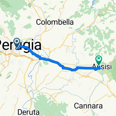
 Perugia - Assisi
- Distance
- 29,5 km
- Montée
- 249 m
- Descente
- 298 m
- Emplacement
- Pérouse, Ombrie, Italie
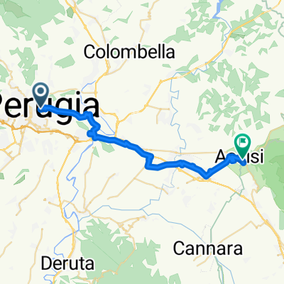
 Piazza IV Novembre, Perugia a Piazza Inferiore San Francesco, Assisi
- Distance
- 22,3 km
- Montée
- 273 m
- Descente
- 394 m
- Emplacement
- Pérouse, Ombrie, Italie
 Ciclofficina - La Fratta Art House
- Distance
- 59,2 km
- Montée
- 342 m
- Descente
- 342 m
- Emplacement
- Pérouse, Ombrie, Italie
 Da ¿?Ø⁄? a ¿?Ø⁄?
- Distance
- 18,3 km
- Montée
- 349 m
- Descente
- 347 m
- Emplacement
- Pérouse, Ombrie, Italie
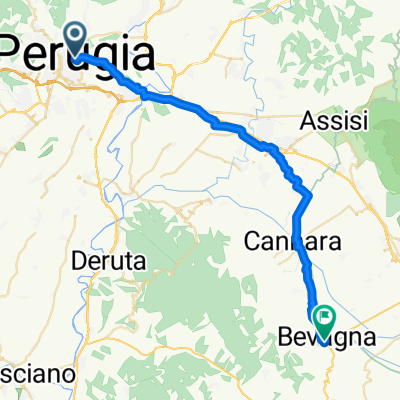 Via Cesare Fani, Pérouse à Corso Giovanni Amendola, Bevagna
- Distance
- 35,3 km
- Montée
- 178 m
- Descente
- 447 m
- Emplacement
- Pérouse, Ombrie, Italie
Ouvre-la dans l’app