

end of a Sunday ride
Un itinéraire vélo au départ de North Kingstown, Rhode Island, États Unis.
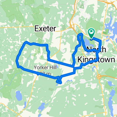
Vue d'ensemble
À propos du circuit
- 1 h 26 min
- Durée
- 34,6 km
- Distance
- 366 m
- Montée
- 361 m
- Descente
- 24,2 km/h
- Vit. moyenne
- ---
- Altitude max.

Qualité de l’itinéraire
Types de voies et surfaces le long de l’itinéraire
Types de routes
Route
28,4 km
(82 %)
Route fréquentée
5 km
(15 %)
surfaces
Pavé
21,3 km
(62 %)
Asphalte
10,7 km
(31 %)
Pavé (non défini)
10,6 km
(31 %)
Indéfini
13,3 km
(38 %)
Continuer avec Bikemap
Utilise, modifie ou télécharge cet itinéraire vélo
Tu veux parcourir end of a Sunday ride ou l’adapter à ton propre voyage ? Voici ce que tu peux faire avec cet itinéraire Bikemap :
Fonctionnalités gratuites
- Enregistre cet itinéraire comme favori ou dans une collection
- Copie et planifie ta propre version de cet itinéraire
- Synchronise ton itinéraire avec Garmin ou Wahoo
Fonctionnalités Premium
Essai gratuit de 3 jours, ou paiement unique. En savoir plus sur Bikemap Premium.
- Navigue sur cet itinéraire sur iOS et Android
- Exporter un fichier GPX / KML de cet itinéraire
- Crée ton impression personnalisée (essaie-la gratuitement)
- Télécharge cet itinéraire pour la navigation hors ligne
Découvre plus de fonctionnalités Premium.
Obtiens Bikemap PremiumDe notre communauté
North Kingstown : Autres itinéraires populaires qui commencent ici
 391 Ten Rod Rd, North Kingstown to 1–99 Corey Ave, North Kingstown
- Distance
- 32,2 km
- Montée
- 413 m
- Descente
- 415 m
- Emplacement
- North Kingstown, Rhode Island, États Unis
 Lengthy ride through SK, Kenyon, Shannock
- Distance
- 58,5 km
- Montée
- 345 m
- Descente
- 337 m
- Emplacement
- North Kingstown, Rhode Island, États Unis
 Through Kingston to Narragansett Beach
- Distance
- 49,9 km
- Montée
- 223 m
- Descente
- 220 m
- Emplacement
- North Kingstown, Rhode Island, États Unis
 hills of Exeter west Greenwich
- Distance
- 41,8 km
- Montée
- 553 m
- Descente
- 554 m
- Emplacement
- North Kingstown, Rhode Island, États Unis
 up the 138 hill from hell.
- Distance
- 34,8 km
- Montée
- 7 m
- Descente
- 30 m
- Emplacement
- North Kingstown, Rhode Island, États Unis
 Route 102 and 165
- Distance
- 74 km
- Montée
- 735 m
- Descente
- 734 m
- Emplacement
- North Kingstown, Rhode Island, États Unis
 Congdon Hill Road 130, North Kingstown to Congdon Hill Road 130, North Kingstown
- Distance
- 21,1 km
- Montée
- 118 m
- Descente
- 126 m
- Emplacement
- North Kingstown, Rhode Island, États Unis
 61 Corey Ave, North Kingstown to 61 Corey Ave, North Kingstown
- Distance
- 35,8 km
- Montée
- 437 m
- Descente
- 437 m
- Emplacement
- North Kingstown, Rhode Island, États Unis
Ouvre-la dans l’app