
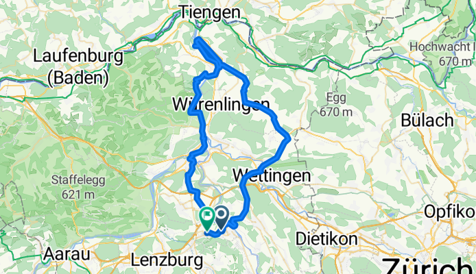
Mägenwil - Stausee Klingnau - Baden - Mägenwil
Un itinéraire vélo au départ de Mellingen, Canton d’Argovie, Suisse.
Vue d'ensemble
À propos du circuit
- 3 h 56 min
- Durée
- 65,6 km
- Distance
- 680 m
- Montée
- 643 m
- Descente
- 16,7 km/h
- Vit. moyenne
- ---
- Altitude max.

Photos de l’itinéraire

Qualité de l’itinéraire
Types de voies et surfaces le long de l’itinéraire
Types de routes
Route tranquille
20,4 km
(31 %)
Route forestière
15,1 km
(23 %)
surfaces
Pavé
55,8 km
(85 %)
Non pavé
3,9 km
(6 %)
Asphalte
53,8 km
(82 %)
Gravier
3,3 km
(5 %)
Continuer avec Bikemap
Utilise, modifie ou télécharge cet itinéraire vélo
Tu veux parcourir Mägenwil - Stausee Klingnau - Baden - Mägenwil ou l’adapter à ton propre voyage ? Voici ce que tu peux faire avec cet itinéraire Bikemap :
Fonctionnalités gratuites
- Enregistre cet itinéraire comme favori ou dans une collection
- Copie et planifie ta propre version de cet itinéraire
- Synchronise ton itinéraire avec Garmin ou Wahoo
Fonctionnalités Premium
Essai gratuit de 3 jours, ou paiement unique. En savoir plus sur Bikemap Premium.
- Navigue sur cet itinéraire sur iOS et Android
- Exporter un fichier GPX / KML de cet itinéraire
- Crée ton impression personnalisée (essaie-la gratuitement)
- Télécharge cet itinéraire pour la navigation hors ligne
Découvre plus de fonctionnalités Premium.
Obtiens Bikemap PremiumDe notre communauté
Mellingen : Autres itinéraires populaires qui commencent ici
 Mägenwil - Stausee Klingnau - Baden - Mägenwil
- Distance
- 65,6 km
- Montée
- 680 m
- Descente
- 643 m
- Emplacement
- Mellingen, Canton d’Argovie, Suisse
 Rütihof-Besuch Zulauf-Rütihof
- Distance
- 37,7 km
- Montée
- 441 m
- Descente
- 489 m
- Emplacement
- Mellingen, Canton d’Argovie, Suisse
 Rütihof - Zürich HB
- Distance
- 31,7 km
- Montée
- 260 m
- Descente
- 261 m
- Emplacement
- Mellingen, Canton d’Argovie, Suisse
 Langsame Fahrt in Rütihof
- Distance
- 0,2 km
- Montée
- 0 m
- Descente
- 0 m
- Emplacement
- Mellingen, Canton d’Argovie, Suisse
 Rütihof - Egelsee AG - Spreitenbach - Rütihof
- Distance
- 39,7 km
- Montée
- 662 m
- Descente
- 662 m
- Emplacement
- Mellingen, Canton d’Argovie, Suisse
 Rütihof - Klingnauer Stausee - Rütihof
- Distance
- 53,9 km
- Montée
- 343 m
- Descente
- 388 m
- Emplacement
- Mellingen, Canton d’Argovie, Suisse
 Maiengrün
- Distance
- 5,4 km
- Montée
- 272 m
- Descente
- 48 m
- Emplacement
- Mellingen, Canton d’Argovie, Suisse
 2020-09-18
- Distance
- 29,5 km
- Montée
- 463 m
- Descente
- 464 m
- Emplacement
- Mellingen, Canton d’Argovie, Suisse
Ouvre-la dans l’app