

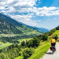
Furka - Grimsel
Un itinéraire vélo au départ de Andermatt, Canton d’Uri, Suisse.
Vue d'ensemble
À propos du circuit
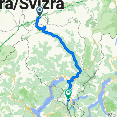
ITINÉRAIRE :
Départ de Hospental. (Juste après le village, il y a un beau parking pour voitures.)
La route est presque plate jusqu'à REALP, où commence l'ascension vers le FURKA. Les pentes sont constantes, entre 6 et 9 %.
Peu après le col, se trouve le BELVEDERE, généralement bondé de touristes. De là, on peut accéder au glacier avec des grottes de glace (payant !).
La descente est belle et rapide, bonne route, vers GLETSCH. De là part aussi le célèbre train à vapeur qui remonte le Furka.
On attaque les lacets du GRIMSEL. Pentes de 8 à 10 %. Au sommet, un joli petit lac et un bar.
De là, part en option la déviation vers le barrage d'Oberardsee, que je n'ai pas prise.
Descente remarquable vers INNERTKIRCHEN. Attention à quelques longs tunnels, mais route en bon état. Je conseille une lumière arrière.
Cet itinéraire fait partie d'un parcours de 3 jours.
- -:--
- Durée
- 60,8 km
- Distance
- 1 309 m
- Montée
- 2 198 m
- Descente
- ---
- Vit. moyenne
- ---
- Altitude max.

Points forts de l’itinéraire
Points d’intérêt le long de l’itinéraire
Point d'intérêt après 21,4 km
Belvedere Furka. Visita ghiacciaio a pagamento.
Continuer avec Bikemap
Utilise, modifie ou télécharge cet itinéraire vélo
Tu veux parcourir Furka - Grimsel ou l’adapter à ton propre voyage ? Voici ce que tu peux faire avec cet itinéraire Bikemap :
Fonctionnalités gratuites
- Enregistre cet itinéraire comme favori ou dans une collection
- Copie et planifie ta propre version de cet itinéraire
- Synchronise ton itinéraire avec Garmin ou Wahoo
Fonctionnalités Premium
Essai gratuit de 3 jours, ou paiement unique. En savoir plus sur Bikemap Premium.
- Navigue sur cet itinéraire sur iOS et Android
- Exporter un fichier GPX / KML de cet itinéraire
- Crée ton impression personnalisée (essaie-la gratuitement)
- Télécharge cet itinéraire pour la navigation hors ligne
Découvre plus de fonctionnalités Premium.
Obtiens Bikemap PremiumDe notre communauté
Andermatt : Autres itinéraires populaires qui commencent ici
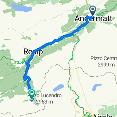
 20.09.2010 Furka, Nufenen, Gotthard
- Distance
- 98,5 km
- Montée
- 2 959 m
- Descente
- 2 959 m
- Emplacement
- Andermatt, Canton d’Uri, Suisse
 Rhine Cycle Route, EuroVelo 15 - Andermatt to Basel
- Distance
- 492,2 km
- Montée
- 6 424 m
- Descente
- 7 590 m
- Emplacement
- Andermatt, Canton d’Uri, Suisse
 Bellinzona - Vizzola Ticino
- Distance
- 130,7 km
- Montée
- 2 639 m
- Descente
- 3 799 m
- Emplacement
- Andermatt, Canton d’Uri, Suisse
 Furka-Nufenen-Gotthard-Oberalp
- Distance
- 135,9 km
- Montée
- 4 637 m
- Descente
- 4 527 m
- Emplacement
- Andermatt, Canton d’Uri, Suisse
 Witenwasseren Bike
- Distance
- 17,3 km
- Montée
- 808 m
- Descente
- 26 m
- Emplacement
- Andermatt, Canton d’Uri, Suisse
 NL The Rhine Cycle Route
- Distance
- 1 352,1 km
- Montée
- 88 m
- Descente
- 1 523 m
- Emplacement
- Andermatt, Canton d’Uri, Suisse
 Andermatt 3
- Distance
- 158,9 km
- Montée
- 3 905 m
- Descente
- 3 702 m
- Emplacement
- Andermatt, Canton d’Uri, Suisse
 Rheinradweg
- Distance
- 1 085,7 km
- Montée
- 107 m
- Descente
- 1 544 m
- Emplacement
- Andermatt, Canton d’Uri, Suisse
Ouvre-la dans l’app