

Brainerd loop for Sue's group of 12
Un itinéraire vélo au départ de Brainerd, Minnesota, États Unis.
Vue d'ensemble
À propos du circuit
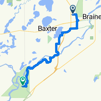
Rendez-vous au départ du sentier et au parking situés à Northland Arboretum.
Prenez la piste en direction ouest sur le connecteur de sentier Paul Bunyan.
Tournez à gauche sur le sentier Paul Bunyan et dirigez-vous vers le sud, en traversant le pont au-dessus d'Excelsior Dr et le passage sous la route nationale 210.
Tournez à droite au 'T' du sentier et dirigez-vous vers l'ouest. Courte distance jusqu'à l'intersection avec Cypress Drive. Suivez le sentier en prenant à droite (sud). Vous longerez la toute nouvelle Cypress Dr sur un sentier fraîchement asphalté.
Restez sur le sentier pavé en tournant à gauche. Vous longerez alors South College Rd. Le sentier traverse facilement plusieurs ronds-points sur ce long segment. Ce segment se termine lorsque vous traversez le fleuve Mississippi.
Une fois le fleuve franchi, le sentier continue vers l'est, le long d'East College Dr. jusqu'au prochain rond-point. Vous éviterez le rond-point en restant sur le sentier et en montant une côte à côté du lycée Brainerd en construction. Vous allez vers le nord le long de South 5th St.
Tournez à droite sur le sentier pavé du côté sud de Oak Street.
Restez sur le sentier pavé Oak Street jusqu'à ce que vous traversiez la 8th St. Puis suivez le sentier vers le nord le long de la 8th pendant 3 pâtés de maisons.
Tournez à gauche (ouest) sur Laurel street sur environ 2 pâtés de maisons jusqu'à arriver à Sage on Laurel (côté gauche/sud de Laurel) où vous prendrez votre déjeuner. Garez vos vélos sur le parking/autour de la zone de terrasse extérieure.
Après le déjeuner, retournez vers l'est le long de Laurel jusqu'au sentier à South 8th.
Tournez à gauche sur le sentier à South 8th en allant vers le nord pendant environ 2 pâtés de maisons.
Traversez Washington St/Hwy 210 au passage piéton.
Une fois passé Washington St./Hwy 210, prenez immédiatement à gauche pour deux pâtés de maisons jusqu'à un sentier à l'intersection de North 10th (petit triangle de type parc avec un sentier menant à un grand parking du Franklin Arts Center).
Continuez à travers le parking du Franklin Arts Center, traversez Kingwood street où le sentier reprend bien.
Continuez vers l'ouest jusqu'à la distillerie 5Rocks qui se trouve au coin de 1st Ave. NE et Washington/Hwy 210.
Prenez un verre !
Faites demi-tour et retournez à l'entrée du sentier de l'Arboretum !
- -:--
- Durée
- 13,6 km
- Distance
- 67 m
- Montée
- 67 m
- Descente
- ---
- Vit. moyenne
- ---
- Altitude max.

Points forts de l’itinéraire
Points d’intérêt le long de l’itinéraire
Point d'intérêt après 0 km
Northland Arboretum Parking and Trail-head. Starting Point

Point d'intérêt après 6,1 km
Sage on Laurel - Lunch

Point d'intérêt après 7,3 km
5Rocks Distilling
Continuer avec Bikemap
Utilise, modifie ou télécharge cet itinéraire vélo
Tu veux parcourir Brainerd loop for Sue's group of 12 ou l’adapter à ton propre voyage ? Voici ce que tu peux faire avec cet itinéraire Bikemap :
Fonctionnalités gratuites
- Enregistre cet itinéraire comme favori ou dans une collection
- Copie et planifie ta propre version de cet itinéraire
- Synchronise ton itinéraire avec Garmin ou Wahoo
Fonctionnalités Premium
Essai gratuit de 3 jours, ou paiement unique. En savoir plus sur Bikemap Premium.
- Navigue sur cet itinéraire sur iOS et Android
- Exporter un fichier GPX / KML de cet itinéraire
- Crée ton impression personnalisée (essaie-la gratuitement)
- Télécharge cet itinéraire pour la navigation hors ligne
Découvre plus de fonctionnalités Premium.
Obtiens Bikemap PremiumDe notre communauté
Brainerd : Autres itinéraires populaires qui commencent ici
 Brainerd Home
- Distance
- 180,4 km
- Montée
- 169 m
- Descente
- 138 m
- Emplacement
- Brainerd, Minnesota, États Unis
 Brainerd loop for Sue's group of 12
- Distance
- 13,6 km
- Montée
- 67 m
- Descente
- 67 m
- Emplacement
- Brainerd, Minnesota, États Unis
 From Baxter to Fort Ripley
- Distance
- 19,8 km
- Montée
- 76 m
- Descente
- 81 m
- Emplacement
- Brainerd, Minnesota, États Unis
 Lake Tour
- Distance
- 68,7 km
- Montée
- 196 m
- Descente
- 195 m
- Emplacement
- Brainerd, Minnesota, États Unis
 510 Laurel St, Brainerd to 301 Minnesota Ave W, Walker
- Distance
- 101,6 km
- Montée
- 159 m
- Descente
- 122 m
- Emplacement
- Brainerd, Minnesota, États Unis
 Paul Bunyan Trail
- Distance
- 152,5 km
- Montée
- 186 m
- Descente
- 138 m
- Emplacement
- Brainerd, Minnesota, États Unis
 GULL-QEQUOT-BREEZY-HOME
- Distance
- 95,2 km
- Montée
- 190 m
- Descente
- 198 m
- Emplacement
- Brainerd, Minnesota, États Unis
 Recovered Route
- Distance
- 21,6 km
- Montée
- 108 m
- Descente
- 101 m
- Emplacement
- Brainerd, Minnesota, États Unis
Ouvre-la dans l’app