

stretton - warburton loop
Un itinéraire vélo au départ de Croft, Angleterre, Royaume-Uni.
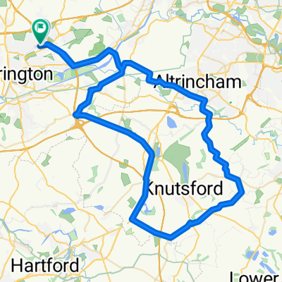
Vue d'ensemble
À propos du circuit
- descendez Fearnhead Lane dans Padgate Lane puis continuez sur Kingsway.
- passez sur le pont de Kingsway et suivez la route.. au 2ème feu, tournez à gauche puis immédiatement à droite le long du canal (montée).
- tournez à gauche au sommet du pont et suivez la route vers le bas en tournant à droite en bas.
- aux feux, tournez à droite puis à gauche au prochain feu (sous un pont) en prenant la première à gauche (Bridge Lane)
- tournez à droite dans Broom Ave qui devient Lyons Road.
- au bout de la route, tournez à gauche dans London Road.
- finalement, tournez à droite dans Hatton Lane.
- lorsque la route se divise, tournez à gauche et passez sous la M6... en tournant à droite dans Pilmoss Lane.
- tournez à gauche dans Newton Lane puis à droite dans Higher Lane.
- tournez à gauche dans Marsh Lane (traversez Tarporley Road dans Heath Lane)
- prenez Ash House Lane à gauche qui devient Coghill Lane - suivez cela et tournez à droite dans Hough Lane.
- quand Hough Lane part vers la droite - ARRÊTEZ sur la route et revenez dans Gogshall Lane en tournant à droite dans Marbury Road.
- tournez à droite dans Budworth Lane - traversez l'A559 dans High Street et rejoignez Westgate Lane. restez à gauche sur Budworth Road.
- tournez à gauche dans CANN Lane et passez sous la M6... vous êtes maintenant dans Whitley Lane.
- tournez à gauche dans Rowey Bank Lane puis à droite dans Halliwells Brow.
- lorsque vous atteignez l'A50, tournez à gauche puis à droite dans W Lane (High Leigh). Suivez cela sous la M56 et dans High Leigh Road.
- à l'A56 (Higher Lane), traversez vers Bullford Lane.
- traversez le canal dans Mill Lane.
- à l'A6144 tournez à droite vers Heatley et à gauche sur la B5159 (Townfield Lane).
- suivez cela à travers la route payante.... et à gauche sur Manchester Road..... puis retour à la maison...
- -:--
- Durée
- 54,6 km
- Distance
- 144 m
- Montée
- 142 m
- Descente
- ---
- Vit. moyenne
- ---
- Altitude max.

Continuer avec Bikemap
Utilise, modifie ou télécharge cet itinéraire vélo
Tu veux parcourir stretton - warburton loop ou l’adapter à ton propre voyage ? Voici ce que tu peux faire avec cet itinéraire Bikemap :
Fonctionnalités gratuites
- Enregistre cet itinéraire comme favori ou dans une collection
- Copie et planifie ta propre version de cet itinéraire
- Synchronise ton itinéraire avec Garmin ou Wahoo
Fonctionnalités Premium
Essai gratuit de 3 jours, ou paiement unique. En savoir plus sur Bikemap Premium.
- Navigue sur cet itinéraire sur iOS et Android
- Exporter un fichier GPX / KML de cet itinéraire
- Crée ton impression personnalisée (essaie-la gratuitement)
- Télécharge cet itinéraire pour la navigation hors ligne
Découvre plus de fonctionnalités Premium.
Obtiens Bikemap PremiumDe notre communauté
Croft : Autres itinéraires populaires qui commencent ici
 leigh 18 miler
- Distance
- 29,4 km
- Montée
- 65 m
- Descente
- 66 m
- Emplacement
- Croft, Angleterre, Royaume-Uni
 74 Sandicroft Close, Warrington to 14 Broadstone Close, Warrington
- Distance
- 13,4 km
- Montée
- 9 m
- Descente
- 8 m
- Emplacement
- Croft, Angleterre, Royaume-Uni
 Route from Moss Gate, Birchwood, Warrington
- Distance
- 12,2 km
- Montée
- 122 m
- Descente
- 89 m
- Emplacement
- Croft, Angleterre, Royaume-Uni
 appleton, stretton, daresbury 29.5mile
- Distance
- 47,5 km
- Montée
- 143 m
- Descente
- 143 m
- Emplacement
- Croft, Angleterre, Royaume-Uni
 to dan's
- Distance
- 6,7 km
- Montée
- 8 m
- Descente
- 8 m
- Emplacement
- Croft, Angleterre, Royaume-Uni
 tatton circular
- Distance
- 55,5 km
- Montée
- 135 m
- Descente
- 135 m
- Emplacement
- Croft, Angleterre, Royaume-Uni
 knutsfors peeover route
- Distance
- 69,8 km
- Montée
- 146 m
- Descente
- 149 m
- Emplacement
- Croft, Angleterre, Royaume-Uni
 OTO Day 1 Stoke
- Distance
- 72,7 km
- Montée
- 235 m
- Descente
- 127 m
- Emplacement
- Croft, Angleterre, Royaume-Uni
Ouvre-la dans l’app