

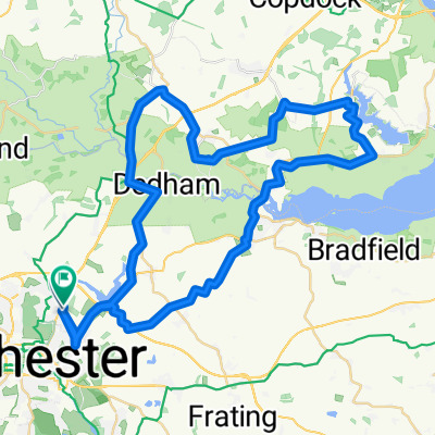
Colchester Loop
Un itinéraire vélo au départ de Colchester, Angleterre, Royaume-Uni.
Vue d'ensemble
À propos du circuit
An 11 mile loop around Colchester starting and finishing at Colchestser Leisure World using mostly bike paths plus a few short sections on low traffic roads. Leaving Leisure World head towards Asda via the industrial/retail area and take the bike path to cross the footbridge near the station. Take the easiest uphill section out of Colchester to Colchester Stadium and it's then flat or downhill most of the way back. Take the bike paths on Axial Way and Severals Lane to St John's, and take the path parallel to St John's Rd to Welshwood. There's a bit of fun off road downhill through the fields at the back of Welshwood - brake evenly all the way down to avoid having to brake heavily at the end. Take the bike path along Salary Brook to the University and cross the zig-zag bridge to B&Q. The home leg is via the park. If required adapt the route to stop for refreshment at the Oak Tree Coffee House near Highwoods' Tesco.
- -:--
- Durée
- 17,9 km
- Distance
- 42 m
- Montée
- 44 m
- Descente
- ---
- Vit. moyenne
- ---
- Altitude max.
Qualité de l’itinéraire
Types de voies et surfaces le long de l’itinéraire
Types de routes
Piste cyclable
8,6 km
(48 %)
Route tranquille
4,1 km
(23 %)
surfaces
Pavé
8,4 km
(47 %)
Non pavé
0,2 km
(1 %)
Asphalte
5,9 km
(33 %)
Pavé (non défini)
2,3 km
(13 %)
Continuer avec Bikemap
Utilise, modifie ou télécharge cet itinéraire vélo
Tu veux parcourir Colchester Loop ou l’adapter à ton propre voyage ? Voici ce que tu peux faire avec cet itinéraire Bikemap :
Fonctionnalités gratuites
- Enregistre cet itinéraire comme favori ou dans une collection
- Copie et planifie ta propre version de cet itinéraire
- Synchronise ton itinéraire avec Garmin ou Wahoo
Fonctionnalités Premium
Essai gratuit de 3 jours, ou paiement unique. En savoir plus sur Bikemap Premium.
- Navigue sur cet itinéraire sur iOS et Android
- Exporter un fichier GPX / KML de cet itinéraire
- Crée ton impression personnalisée (essaie-la gratuitement)
- Télécharge cet itinéraire pour la navigation hors ligne
Découvre plus de fonctionnalités Premium.
Obtiens Bikemap PremiumDe notre communauté
Colchester : Autres itinéraires populaires qui commencent ici
 Bures Campsite
- Distance
- 25,5 km
- Montée
- 133 m
- Descente
- 115 m
- Emplacement
- Colchester, Angleterre, Royaume-Uni
 Oops - Thought it stopped at Manningtree
- Distance
- 19,8 km
- Montée
- 74 m
- Descente
- 67 m
- Emplacement
- Colchester, Angleterre, Royaume-Uni
 Col to Harwich loop46
- Distance
- 74,4 km
- Montée
- 235 m
- Descente
- 235 m
- Emplacement
- Colchester, Angleterre, Royaume-Uni
 Manningtree/Flatford2
- Distance
- 54,1 km
- Montée
- 154 m
- Descente
- 152 m
- Emplacement
- Colchester, Angleterre, Royaume-Uni
 Lyndsay and Amanda’s 50k cycle!
- Distance
- 56,3 km
- Montée
- 358 m
- Descente
- 356 m
- Emplacement
- Colchester, Angleterre, Royaume-Uni
 Colchester to Harwich Loop
- Distance
- 71,9 km
- Montée
- 336 m
- Descente
- 375 m
- Emplacement
- Colchester, Angleterre, Royaume-Uni
 EA24: Day 2 Colchester - Felixstowe
- Distance
- 82,9 km
- Montée
- 415 m
- Descente
- 424 m
- Emplacement
- Colchester, Angleterre, Royaume-Uni
 Horkesley, the Tey's & the Layer's Loop
- Distance
- 62,7 km
- Montée
- 181 m
- Descente
- 184 m
- Emplacement
- Colchester, Angleterre, Royaume-Uni
Ouvre-la dans l’app