

MOUNTAINBIKE-TOUR "ALP GAMIDAUR BIKE" Nr. 471
Un itinéraire vélo au départ de Bad Ragaz, Canton of St. Gallen, Switzerland.
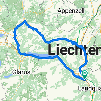
Vue d'ensemble
À propos du circuit
Auf dieser Tour geniesst man sagenhafte Einblicke ins malerische Weisstannental, verträumte Alpen und wild verwachsene Natur. Der Grossteil der Strecke verläuft auf Naturwegen.
- -:--
- Durée
- 34,7 km
- Distance
- 1 474 m
- Montée
- 1 471 m
- Descente
- ---
- Vit. moyenne
- ---
- Altitude max.

Qualité de l’itinéraire
Types de voies et surfaces le long de l’itinéraire
Types de routes
Route forestière
20,7 km
(60 %)
Route tranquille
9,4 km
(27 %)
surfaces
Pavé
13,7 km
(39 %)
Non pavé
19,1 km
(55 %)
Gravier
16,3 km
(47 %)
Asphalte
10,2 km
(30 %)
Continuer avec Bikemap
Utilise, modifie ou télécharge cet itinéraire vélo
Tu veux parcourir MOUNTAINBIKE-TOUR "ALP GAMIDAUR BIKE" Nr. 471 ou l’adapter à ton propre voyage ? Voici ce que tu peux faire avec cet itinéraire Bikemap :
Fonctionnalités gratuites
- Enregistre cet itinéraire comme favori ou dans une collection
- Copie et planifie ta propre version de cet itinéraire
- Synchronise ton itinéraire avec Garmin ou Wahoo
Fonctionnalités Premium
Essai gratuit de 3 jours, ou paiement unique. En savoir plus sur Bikemap Premium.
- Navigue sur cet itinéraire sur iOS et Android
- Exporter un fichier GPX / KML de cet itinéraire
- Crée ton impression personnalisée (essaie-la gratuitement)
- Télécharge cet itinéraire pour la navigation hors ligne
Découvre plus de fonctionnalités Premium.
Obtiens Bikemap PremiumDe notre communauté
Bad Ragaz : Autres itinéraires populaires qui commencent ici
 Entspannende Route in Bad Ragaz
- Distance
- 10,4 km
- Montée
- 159 m
- Descente
- 105 m
- Emplacement
- Bad Ragaz, Canton of St. Gallen, Switzerland
 Knackige Fahrt in Bad Ragaz
- Distance
- 19,8 km
- Montée
- 323 m
- Descente
- 324 m
- Emplacement
- Bad Ragaz, Canton of St. Gallen, Switzerland
 BadRagaz — WeierPfäfers
- Distance
- 14,8 km
- Montée
- 852 m
- Descente
- 851 m
- Emplacement
- Bad Ragaz, Canton of St. Gallen, Switzerland
 Rund um die Churfirsten
- Distance
- 129,7 km
- Montée
- 945 m
- Descente
- 945 m
- Emplacement
- Bad Ragaz, Canton of St. Gallen, Switzerland
 Moderate Route in Bad Ragaz
- Distance
- 14,7 km
- Montée
- 246 m
- Descente
- 248 m
- Emplacement
- Bad Ragaz, Canton of St. Gallen, Switzerland
 Gemütliche Route in Bad Ragaz
- Distance
- 26 km
- Montée
- 820 m
- Descente
- 811 m
- Emplacement
- Bad Ragaz, Canton of St. Gallen, Switzerland
 CH GR Heidiland-Fläsch-Timmis
- Distance
- 25,3 km
- Montée
- 330 m
- Descente
- 187 m
- Emplacement
- Bad Ragaz, Canton of St. Gallen, Switzerland
 Einfache Fahrt in Bad Ragaz
- Distance
- 3,7 km
- Montée
- 57 m
- Descente
- 54 m
- Emplacement
- Bad Ragaz, Canton of St. Gallen, Switzerland
Ouvre-la dans l’app