B2B00784 55125>55164 via Up.Afton/Ruth/Mhaha/JohnsonPkwy/Wheelock/Edgerton/VadLake/Rice/Gramsie/Lex
Un itinéraire vélo au départ de Maplewood, Minnesota, United States of America.
Vue d'ensemble
Ă€ propos du circuit
Take Upper Afton west to Ruth. Turn right and follow Ruth to Minnehaha. Turn left at Minnehaha and continue to Johnson Pkwy. Turn right at Johnson Parkway and continue to Lake Phalen. Veer to the left on to Wheelock Pkwy. Continue on Wheelock Pkwy across Hwy. 61 and on to Edgerton Street. Turn right at Edgerton. Follow Edgerton north past Larpenteur and over Highway 36. Past Gervais Lake on your right and over 694 to Vadnais Lake Blvd. Turn left and follow Vadnais Lake Blvd. around the lake until you come to Rice Street. Turn right at Rice Street and continue north on Rice to Gramsie Rd. At the top of the big hill turn right at Victoria. Take Victoria to County Rd. F and turn left. Follow Cty. F to Lexington and turn left. Go south on Lexington to 4001 and your destination.
- -:--
- Durée
- 27,1 km
- Distance
- 127 m
- Montée
- 137 m
- Descente
- ---
- Vit. moyenne
- 304 m
- Altitude max.
Qualité de l’itinéraire
Types de voies et surfaces le long de l’itinéraire
Types de routes
Route
18,1 km
(67 %)
Piste cyclable
5 km
(18 %)
surfaces
Pavé
10,9 km
(40 %)
Asphalte
8,5 km
(31 %)
Béton
1,6 km
(6 %)
Points forts de l’itinéraire
Points d’intérêt le long de l’itinéraire
Point d'intérêt après 19,9 km
You can take the road through the lake at this point to County Rd. F and then left to Gramsie and Rice. THe gate is not open during the late fall and winter.
Continuer avec Bikemap
Utilise, modifie ou télécharge cet itinéraire vélo
Tu veux parcourir B2B00784 55125>55164 via Up.Afton/Ruth/Mhaha/JohnsonPkwy/Wheelock/Edgerton/VadLake/Rice/Gramsie/Lex ou l’adapter à ton propre voyage ? Voici ce que tu peux faire avec cet itinéraire Bikemap :
Fonctionnalités gratuites
- Enregistre cet itinéraire comme favori ou dans une collection
- Copie et planifie ta propre version de cet itinéraire
- Synchronise ton itinéraire avec Garmin ou Wahoo
Fonctionnalités Premium
Essai gratuit de 3 jours, ou paiement unique. En savoir plus sur Bikemap Premium.
- Navigue sur cet itinéraire sur iOS et Android
- Exporter un fichier GPX / KML de cet itinéraire
- Crée ton impression personnalisée (essaie-la gratuitement)
- Télécharge cet itinéraire pour la navigation hors ligne
Découvre plus de fonctionnalités Premium.
Obtiens Bikemap PremiumDe notre communauté
Maplewood : Autres itinéraires populaires qui commencent ici
- B2B00784 55125>55164 via Up.Afton/Ruth/Mhaha/JohnsonPkwy/Wheelock/Edgerton/VadLake/Rice/Gramsie/Lex
- Distance
- 27,1 km
- Montée
- 127 m
- Descente
- 137 m
- Emplacement
- Maplewood, Minnesota, United States of America
- WB CTY PARK
- Distance
- 17,3 km
- Montée
- 59 m
- Descente
- 71 m
- Emplacement
- Maplewood, Minnesota, United States of America
- Maplewood Cycling
- Distance
- 14,1 km
- Montée
- 450 m
- Descente
- 299 m
- Emplacement
- Maplewood, Minnesota, United States of America
- B2B00576 55119>55110 via Upper Afton Rd, Johnson Pkwy, Bruce Vento Trl
- Distance
- 17,1 km
- Montée
- 74 m
- Descente
- 100 m
- Emplacement
- Maplewood, Minnesota, United States of America
- B2B00497 55106>55082 via Bruce Vento Trl, Gateway Trl, Myrtle Av
- Distance
- 28,4 km
- Montée
- 92 m
- Descente
- 89 m
- Emplacement
- Maplewood, Minnesota, United States of America
- B2B00956 55119>55401 via Case Av, Como Av, 4th St SE
- Distance
- 24 km
- Montée
- 159 m
- Descente
- 192 m
- Emplacement
- Maplewood, Minnesota, United States of America
- Mississippi River Trail: Maplewood to Columbia Heights
- Distance
- 35,3 km
- Montée
- 256 m
- Descente
- 222 m
- Emplacement
- Maplewood, Minnesota, United States of America
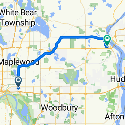
- B2B00211 55119>55101 via Upper Afton, 7th Street
- Distance
- 17,8 km
- Montée
- 189 m
- Descente
- 192 m
- Emplacement
- Maplewood, Minnesota, United States of America
Ouvre-la dans l’app