

Faro Touring Tour
Un itinéraire vélo au départ de Faro, Faro, Portugal.
Vue d'ensemble
À propos du circuit
À propos de l'itinéraire
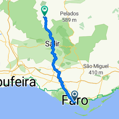
• Début et fin de l'itinéraire : Faro (Praça Dom Francisco Gomes)
• Niveau de difficulté : Facile
• Temps nécessaire : Environ 3h00 à une moyenne de 12 km/h
• Altimétrie : 386 m de montée, 386 m de descente
• Coordonnées GPS : 37.01614, -7.93537
• Distance : 38 km
Description
Du port de plaisance du centre-ville, commencez par parcourir la vieille ville historique de Faro. Une fois que vous atteignez la périphérie de la ville, l'itinéraire vous emmène dans la partie intérieure de la municipalité, à travers le village de Conceição et, plus loin, Estoi. Il y a plusieurs endroits intéressants à visiter à Estoi, tels que la place Ossónoba, située dans la partie la plus ancienne de la ville, la Pousada du Palais d'Estoi, l'église principale et les ruines de la villa romaine de Milreu. En contournant la colline de Guelhim, vous rencontrerez le petit village de Santa Bárbara de Nexe, avec sa magnifique église principale.
Le retour à la capitale de la municipalité se fait principalement en descente et sur un terrain plat, en passant par la zone forestière de Ludo.
- -:--
- Durée
- 38 km
- Distance
- 393 m
- Montée
- 393 m
- Descente
- ---
- Vit. moyenne
- ---
- Altitude max.

Qualité de l’itinéraire
Types de voies et surfaces le long de l’itinéraire
Types de routes
Route tranquille
17,1 km
(45 %)
Route
12,5 km
(33 %)
surfaces
Pavé
8 km
(21 %)
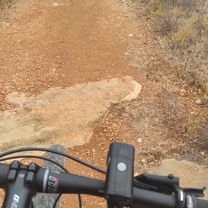
Non pavé
5,7 km
(15 %)
Asphalte
8 km
(21 %)
Gravier
3,4 km
(9 %)
Points forts de l’itinéraire
Points d’intérêt le long de l’itinéraire

Point d'intérêt après 0,2 km
Arco da Vila

Point d'intérêt après 0,4 km
Sé de Faro
Point d'intérêt après 9,9 km
Conceição de Faro
Point d'intérêt après 15,2 km
Palácio de Estoi
Point d'intérêt après 15,5 km
Igreja Matriz de Estoi
Point d'intérêt après 16,4 km
Ruínas Romanas de Milreu
Point d'intérêt après 24,1 km
Santa Bárbara de Nexe
Point d'intérêt après 26,4 km
Estádio do Algarve
Point d'intérêt après 30 km
Zona florestal do Ludo

Point d'intérêt après 36,4 km
Parque Ribeirinho
Continuer avec Bikemap
Utilise, modifie ou télécharge cet itinéraire vélo
Tu veux parcourir Faro Touring Tour ou l’adapter à ton propre voyage ? Voici ce que tu peux faire avec cet itinéraire Bikemap :
Fonctionnalités gratuites
- Enregistre cet itinéraire comme favori ou dans une collection
- Copie et planifie ta propre version de cet itinéraire
- Synchronise ton itinéraire avec Garmin ou Wahoo
Fonctionnalités Premium
Essai gratuit de 3 jours, ou paiement unique. En savoir plus sur Bikemap Premium.
- Navigue sur cet itinéraire sur iOS et Android
- Exporter un fichier GPX / KML de cet itinéraire
- Crée ton impression personnalisée (essaie-la gratuitement)
- Télécharge cet itinéraire pour la navigation hors ligne
Découvre plus de fonctionnalités Premium.
Obtiens Bikemap PremiumDe notre communauté
Faro : Autres itinéraires populaires qui commencent ici
 Faro Touring Tour
- Distance
- 38 km
- Montée
- 393 m
- Descente
- 393 m
- Emplacement
- Faro, Faro, Portugal
 Tortugal Skate To Escape trip
- Distance
- 344,5 km
- Montée
- 789 m
- Descente
- 742 m
- Emplacement
- Faro, Faro, Portugal
 De Rua Coronel António Santos Fonseca 8, Faro a EM525 9, Loulé
- Distance
- 27,8 km
- Montée
- 153 m
- Descente
- 312 m
- Emplacement
- Faro, Faro, Portugal
 Petite balade au Portugal
- Distance
- 429,1 km
- Montée
- 1 117 m
- Descente
- 1 082 m
- Emplacement
- Faro, Faro, Portugal
 Faro Quarteira
- Distance
- 26,4 km
- Montée
- 99 m
- Descente
- 100 m
- Emplacement
- Faro, Faro, Portugal
 Faro - Almodôvar
- Distance
- 53 km
- Montée
- 1 308 m
- Descente
- 837 m
- Emplacement
- Faro, Faro, Portugal
 da Faro a Lisbona a Porto a Fisterra a Santiago de Compostela
- Distance
- 965,5 km
- Montée
- 8 535 m
- Descente
- 8 561 m
- Emplacement
- Faro, Faro, Portugal
 Faro - Lisbon
- Distance
- 355,5 km
- Montée
- 813 m
- Descente
- 761 m
- Emplacement
- Faro, Faro, Portugal
Ouvre-la dans l’app