

Hadovna-U Dubu-Pod Ondrejovskem-U Obrazku-Lukov (castle)-Bezednik-Vela 23 km (Frystak, Zlin area)
Un itinéraire vélo au départ de Fryšták, Zlín, Czechia.
Vue d'ensemble
À propos du circuit
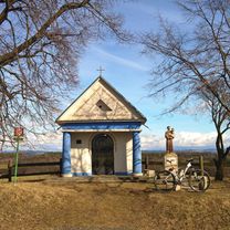
A short but quite demanding trip. I learnt that Beskydy hills are suprisingly demanding compare to Fatra or Nizke Tatry hills/mountains. The terrain and the routes are going up, then down, then up, sort of rollercoaster. The surface is not the most comfortable, definitely it is for MTB (best FS). But here, this route, is sort of OK. Situated north of Zlin city, it is an enter to Beskydy hills to show you what they can offer. It is a shame I do not have GPX of "Solan" area circle route, that was real-real demanding trip (technically as well). Here you can visit some attractions, Lukov castle, there are some nice wells and a small green lake. You can leave your car at Hadovna place, there is a tarmac road uphill and then the show will start :). Definitely you will meet a lot of people, tourists, near wells and especially around Lukov castle so you can have a chit-chat.
- -:--
- Durée
- 22,9 km
- Distance
- 822 m
- Montée
- 816 m
- Descente
- ---
- Vit. moyenne
- ---
- Altitude max.

Photos de l’itinéraire
-Bezednik-Vela 23 km (Frystak, Zlin area) »")
-Bezednik-Vela 23 km (Frystak, Zlin area) »")
-Bezednik-Vela 23 km (Frystak, Zlin area) »")
-Bezednik-Vela 23 km (Frystak, Zlin area) »")
-Bezednik-Vela 23 km (Frystak, Zlin area) »")
-Bezednik-Vela 23 km (Frystak, Zlin area) »")
-Bezednik-Vela 23 km (Frystak, Zlin area) »")
-Bezednik-Vela 23 km (Frystak, Zlin area) »")
Qualité de l’itinéraire
Types de voies et surfaces le long de l’itinéraire
Types de routes
Route forestière
20 km
(87 %)
Sentier
2,3 km
(10 %)
Route tranquille
0,6 km
(3 %)
surfaces
Pavé
7,4 km
(32 %)
Non pavé
13,4 km
(59 %)
Sol
11 km
(48 %)
Asphalte
4,4 km
(19 %)
Continuer avec Bikemap
Utilise, modifie ou télécharge cet itinéraire vélo
Tu veux parcourir Hadovna-U Dubu-Pod Ondrejovskem-U Obrazku-Lukov (castle)-Bezednik-Vela 23 km (Frystak, Zlin area) ou l’adapter à ton propre voyage ? Voici ce que tu peux faire avec cet itinéraire Bikemap :
Fonctionnalités gratuites
- Enregistre cet itinéraire comme favori ou dans une collection
- Copie et planifie ta propre version de cet itinéraire
- Synchronise ton itinéraire avec Garmin ou Wahoo
Fonctionnalités Premium
Essai gratuit de 3 jours, ou paiement unique. En savoir plus sur Bikemap Premium.
- Navigue sur cet itinéraire sur iOS et Android
- Exporter un fichier GPX / KML de cet itinéraire
- Crée ton impression personnalisée (essaie-la gratuitement)
- Télécharge cet itinéraire pour la navigation hors ligne
Découvre plus de fonctionnalités Premium.
Obtiens Bikemap PremiumDe notre communauté
Fryšták : Autres itinéraires populaires qui commencent ici
 Kostelec - Rusava - Koselec
- Distance
- 29,5 km
- Montée
- 573 m
- Descente
- 578 m
- Emplacement
- Fryšták, Zlín, Czechia
 Rehabilitační :)
- Distance
- 26,9 km
- Montée
- 141 m
- Descente
- 151 m
- Emplacement
- Fryšták, Zlín, Czechia
 Dolní Ves, Fryšták to Česká 4753, Zlín
- Distance
- 3,5 km
- Montée
- 52 m
- Descente
- 106 m
- Emplacement
- Fryšták, Zlín, Czechia
 Zlín-Štákovy paseky-Zboženské rybníky-Kocanda
- Distance
- 23,2 km
- Montée
- 373 m
- Descente
- 466 m
- Emplacement
- Fryšták, Zlín, Czechia
 zlín - bystřice pod hostýnem
- Distance
- 38,6 km
- Montée
- 1 128 m
- Descente
- 1 072 m
- Emplacement
- Fryšták, Zlín, Czechia
 frystak tesak
- Distance
- 22,4 km
- Montée
- 573 m
- Descente
- 167 m
- Emplacement
- Fryšták, Zlín, Czechia
 Frystak-Rusava-Chvalcov-Tesak-Trojak-Hostalkova-Lhota u Vsetina-Liptal-Trnava
- Distance
- 72,6 km
- Montée
- 1 288 m
- Descente
- 1 216 m
- Emplacement
- Fryšták, Zlín, Czechia
 Kostelec - Prusinovice
- Distance
- 26,2 km
- Montée
- 399 m
- Descente
- 399 m
- Emplacement
- Fryšták, Zlín, Czechia
Ouvre-la dans l’app