

B2B00870 55116>55343 via MississippiRvBlvd/LakeStBridge/W.RiverRd/Greenway/Blake/Excel
Un itinéraire vélo au départ de Mendota Heights, Minnesota, États Unis.
Vue d'ensemble
À propos du circuit
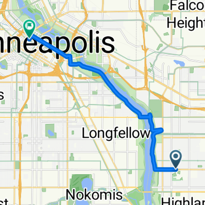
Prenez Hartford jusqu'à Mississippi River Blvd. Tournez à droite et continuez jusqu'au pont Marshall/Lake St. Traversez vers Minneapolis et tournez à droite sur West River Road. Continuez vers le nord sur West River Road jusqu'à la 27th Avenue (juste avant le pont) et la rampe vers le sentier de vélo Greenway. À la 28th Street, vous pouvez soit traverser Hiawatha Avenue avec le feu rouge, soit aller vers le nord et prendre le nouveau pont Martin Sabo au-dessus de Hiawatha. Prenez le Greenway vers l'ouest jusqu'à Blake Road. Tournez à gauche sur Excelsior Blvd. Tournez à gauche sur Excelsior Blvd vers Interlachen Road. Tournez à droite vers votre destination.
- -:--
- Durée
- 21,2 km
- Distance
- 114 m
- Montée
- 96 m
- Descente
- ---
- Vit. moyenne
- ---
- Altitude max.
Points forts de l’itinéraire
Points d’intérêt le long de l’itinéraire
Point d'intérêt après 7,4 km
At this point you can either cross Hiawatha directly or take the Martin Sabo bridge to the north.
Continuer avec Bikemap
Utilise, modifie ou télécharge cet itinéraire vélo
Tu veux parcourir B2B00870 55116>55343 via MississippiRvBlvd/LakeStBridge/W.RiverRd/Greenway/Blake/Excel ou l’adapter à ton propre voyage ? Voici ce que tu peux faire avec cet itinéraire Bikemap :
Fonctionnalités gratuites
- Enregistre cet itinéraire comme favori ou dans une collection
- Copie et planifie ta propre version de cet itinéraire
- Synchronise ton itinéraire avec Garmin ou Wahoo
Fonctionnalités Premium
Essai gratuit de 3 jours, ou paiement unique. En savoir plus sur Bikemap Premium.
- Navigue sur cet itinéraire sur iOS et Android
- Exporter un fichier GPX / KML de cet itinéraire
- Crée ton impression personnalisée (essaie-la gratuitement)
- Télécharge cet itinéraire pour la navigation hors ligne
Découvre plus de fonctionnalités Premium.
Obtiens Bikemap PremiumDe notre communauté
Mendota Heights : Autres itinéraires populaires qui commencent ici
 South Minnehaha Drive 4935-4925, Minneapolis to South Minnehaha Drive, Minneapolis
- Distance
- 39,9 km
- Montée
- 10 m
- Descente
- 3 m
- Emplacement
- Mendota Heights, Minnesota, États Unis
 B2B00191 55115>55401viaRandolph/MissBlvd/LkStBridge/WRiverPkwy/WashAv
- Distance
- 11,6 km
- Montée
- 97 m
- Descente
- 109 m
- Emplacement
- Mendota Heights, Minnesota, États Unis
 Mendota to Calhoun
- Distance
- 22 km
- Montée
- 171 m
- Descente
- 132 m
- Emplacement
- Mendota Heights, Minnesota, États Unis
 Big Rivers, Pilot Knob, Acadia, Valley Park, ...
- Distance
- 13,3 km
- Montée
- 206 m
- Descente
- 206 m
- Emplacement
- Mendota Heights, Minnesota, États Unis
 Fort Snelling Loop
- Distance
- 33,8 km
- Montée
- 162 m
- Descente
- 164 m
- Emplacement
- Mendota Heights, Minnesota, États Unis
 B2B 55116 > 55106 via Summit Ave, Kellogg Blvd E
- Distance
- 14,3 km
- Montée
- 40 m
- Descente
- 63 m
- Emplacement
- Mendota Heights, Minnesota, États Unis
 B2B00870 55116>55343 via MississippiRvBlvd/LakeStBridge/W.RiverRd/Greenway/Blake/Excel
- Distance
- 21,2 km
- Montée
- 114 m
- Descente
- 96 m
- Emplacement
- Mendota Heights, Minnesota, États Unis
 River Loop
- Distance
- 15,5 km
- Montée
- 99 m
- Descente
- 98 m
- Emplacement
- Mendota Heights, Minnesota, États Unis
Ouvre-la dans l’app