- 22,4 km
- 78 m
- 80 m
- Chiang Mai, Chiang Mai, Thaïlande
Samoeng Loop
Un itinéraire vélo au départ de Chiang Mai, Chiang Mai, Thaïlande.
Vue d'ensemble
À propos du circuit
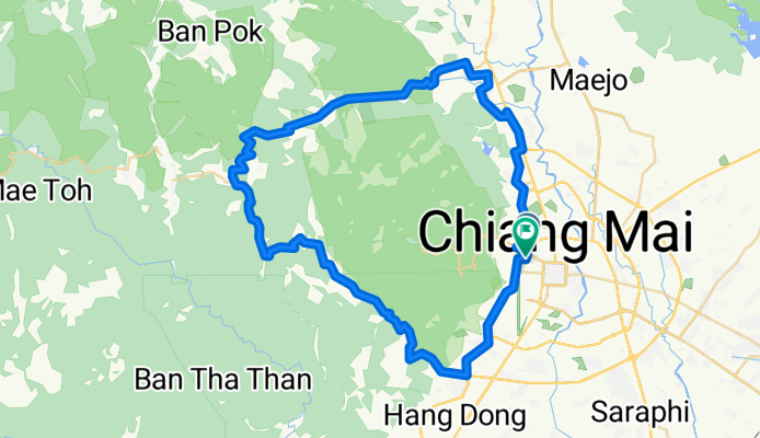
Classic Ride around the mountains of Chiang Mai:
From Chiang Mai take Canal Road South to Samoeng Intersection. Then enter the valley in Eastern direction eventually starting to climb. After km 35 and reaching an altitude of approx 800 m, several steep switchbacks will take you down to about 550 m above sea level. The next climb is 5 kms and 400 m climb.
After the next downhill of about 2 km, take a right turn direction Mae Rim and do the third and final climb.
You will be rewarded with a nice and extended downhill.
At km 69 turn right, and at km 71 - after crossing a bridge - again right. Then follow the road along the river until you reach highway 107. U-turn there and follow direction Chiang Mai then at km 78 turn right at the traffic lights to follow Canal Road back to Chiang Mai.
- -:--
- Durée
- 87,7 km
- Distance
- 1 132 m
- Montée
- 1 130 m
- Descente
- ---
- Vit. moyenne
- ---
- Altitude max.
créé il y a 15 ans
Continuer avec Bikemap
Utilise, modifie ou télécharge cet itinéraire vélo
Tu veux parcourir Samoeng Loop ou l’adapter à ton propre voyage ? Voici ce que tu peux faire avec cet itinéraire Bikemap :
Fonctionnalités gratuites
- Enregistre cet itinéraire comme favori ou dans une collection
- Copie et planifie ta propre version de cet itinéraire
- Divise-le en étapes pour créer un tour sur plusieurs jours
- Synchronise ton itinéraire avec Garmin ou Wahoo
Fonctionnalités Premium
Essai gratuit de 3 jours, ou paiement unique. En savoir plus sur Bikemap Premium.
- Navigue sur cet itinéraire sur iOS et Android
- Exporter un fichier GPX / KML de cet itinéraire
- Crée ton impression personnalisée (essaie-la gratuitement)
- Télécharge cet itinéraire pour la navigation hors ligne
Découvre plus de fonctionnalités Premium.
Obtiens Bikemap PremiumDe notre communauté
Chiang Mai : Autres itinéraires populaires qui commencent ici
- circle round the airport
- Chiang Mai Provincial Livestock Office to Mu Ban Seagames Village Orange Road
- 72,3 km
- 3 879 m
- 3 854 m
- Chiang Mai, Chiang Mai, Thaïlande
- 18.805, 98.960 to 18.803, 98.960
- 25,9 km
- 85 m
- 87 m
- Chiang Mai, Chiang Mai, Thaïlande
- Chiang Mai - Mae Tha
- 64,7 km
- 313 m
- 235 m
- Chiang Mai, Chiang Mai, Thaïlande
- War San Pu Loei
- 36,4 km
- 84 m
- 90 m
- Chiang Mai, Chiang Mai, Thaïlande
- Thailand 3 (traced)
- 457,2 km
- 6 691 m
- 6 644 m
- Chiang Mai, Chiang Mai, Thaïlande
- Sitthiwong Road, Mueang Chiang Mai District to Sitthiwong Road, Mueang Chiang Mai District
- 28,7 km
- 139 m
- 140 m
- Chiang Mai, Chiang Mai, Thaïlande
- Chiang Mai - Mae Tha
- 69,4 km
- 321 m
- 256 m
- Chiang Mai, Chiang Mai, Thaïlande
Ouvre-la dans l’app


