

00. Reykjavik Day Ride
Un itinéraire vélo au départ de Seltjarnarnes, Région de la capitale, Islande.
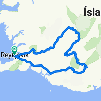
Vue d'ensemble
À propos du circuit
- -:--
- Durée
- 76,4 km
- Distance
- 237 m
- Montée
- 237 m
- Descente
- ---
- Vit. moyenne
- 73 m
- Altitude max.

Qualité de l’itinéraire
Types de voies et surfaces le long de l’itinéraire
Types de routes
Sentier
42 km
(55 %)
Piste cyclable
15,3 km
(20 %)
surfaces
Pavé
68,8 km
(90 %)
Non pavé
5,3 km
(7 %)
Asphalte
68,8 km
(90 %)
Non pavé (non défini)
2,3 km
(3 %)
Points forts de l’itinéraire
Points d’intérêt le long de l’itinéraire
Point d'intérêt après 5,1 km
Grotta Island Walking Path. Low tide only. Not before 15 July due to nesting Terns.
Point d'intérêt après 13,4 km
Nauthólsvík Geothermal Beach
Point d'intérêt après 14,8 km
Perlan has been built primarily as a hot water tank for the supply of Iceland's capital Reykjavík. The planning was designed by Ingimundur Sveinsson and in 1991 the building was opened. From here, the city is supplied with hot water, even for partially heated in winter walkways and roads. The Perlan is also a pearl of Reykjavik. Few viewing platforms of this kind are freely accessible. In order to enjoy the beautiful view of the city and the southwest Iceland, you have to do only a hike or bike ride on this approximately 61 m high hill. The building itself is 25.70 m high. The glass dome on the roof has 1176 window elements and almost 950 bulbs create the illusion of a starry sky. During the day, the sun is reflected in the building and in the dark it is illuminated by 58 floodlights. In addition, inside the Perlan and in the immediate vicinity artificial geysers were installed with information boards, so that one is also informed free of charge. The Sagamuseum in a disused tank is as well worth seeing as the artistic sculptures outside.
Point d'intérêt après 16,8 km
Fossvogsbakkar
Point d'intérêt après 18,4 km
Kópavogskirkja a church in Kópavogur, Iceland. It is located on Borgarholt hill at the top of Kársnes and offers a great view over Kópavogur, Reykjavík and surrounding area.Work on it began in 1958 and it was opened on December 16, 1963. The architectural style of Kópavogskirkja is modernist. Its architecture is unusual, it is the cross section of two wide arches. A curved arch protrudes in each direction with smaller arches extending below. Its profile is prominent in the Kópavogur town seal. Architect Hörður Bjarnason together with Ragnar Emilsson designed this church. The church attracts the attention of both Icelanders and foreign tourists. The altarpiece in the church was set up in 1990 and is by artist Steinunni Þórarinsdóttir. Artist Barbara Árnason (1911–1975) designed various pictures that are in the church. Sculptor Gerður Helgadóttir (1928–1975) designed a sculptor.
Point d'intérêt après 20,3 km
Kópavogur - Hafen Fishing Harbour
Point d'intérêt après 26,2 km
Garðahraun Lavafield
Point d'intérêt après 30,6 km
Blick nach Bessastaðir
Point d'intérêt après 48,3 km
Wasserfall am Elliðaár
Point d'intérêt après 65,6 km
Hjólið Viking Museum
Point d'intérêt après 72,8 km
Sólfar - sculpture
Point d'intérêt après 73,6 km
Traðarkot mit Blick zum Nationaltheater
Point d'intérêt après 75 km
Tjörnin See - Lake
Point d'intérêt après 75,8 km
National Museum of Iceland More information can be found on the museum's website: thjodminjasafn.is/english
Continuer avec Bikemap
Utilise, modifie ou télécharge cet itinéraire vélo
Tu veux parcourir 00. Reykjavik Day Ride ou l’adapter à ton propre voyage ? Voici ce que tu peux faire avec cet itinéraire Bikemap :
Fonctionnalités gratuites
- Enregistre cet itinéraire comme favori ou dans une collection
- Copie et planifie ta propre version de cet itinéraire
- Synchronise ton itinéraire avec Garmin ou Wahoo
Fonctionnalités Premium
Essai gratuit de 3 jours, ou paiement unique. En savoir plus sur Bikemap Premium.
- Navigue sur cet itinéraire sur iOS et Android
- Exporter un fichier GPX / KML de cet itinéraire
- Crée ton impression personnalisée (essaie-la gratuitement)
- Télécharge cet itinéraire pour la navigation hors ligne
Découvre plus de fonctionnalités Premium.
Obtiens Bikemap PremiumDe notre communauté
Seltjarnarnes : Autres itinéraires populaires qui commencent ici
 Iceland 2016 - 3
- Distance
- 1 359,3 km
- Montée
- 2 240 m
- Descente
- 2 246 m
- Emplacement
- Seltjarnarnes, Région de la capitale, Islande
 heim úr vinnunni smá auka krókur
- Distance
- 17,8 km
- Montée
- 44 m
- Descente
- 44 m
- Emplacement
- Seltjarnarnes, Région de la capitale, Islande
 Vesturgata 41, Reykjavík to Vonarstræti 4, Reykjavík
- Distance
- 0,9 km
- Montée
- 32 m
- Descente
- 69 m
- Emplacement
- Seltjarnarnes, Région de la capitale, Islande
 Islanda itinerario 2
- Distance
- 606,1 km
- Montée
- 2 122 m
- Descente
- 2 124 m
- Emplacement
- Seltjarnarnes, Région de la capitale, Islande
 Hjólað í og úr vinnu
- Distance
- 20,4 km
- Montée
- 79 m
- Descente
- 79 m
- Emplacement
- Seltjarnarnes, Région de la capitale, Islande
 Day 1
Day 1- Distance
- 116 km
- Montée
- 605 m
- Descente
- 405 m
- Emplacement
- Seltjarnarnes, Région de la capitale, Islande
 Ólafshringur: Reykjavík Ring-1. Complete Metropolitan Ring: Seltjarnarnes, Reykjavík, Kópavogur, Arnarnes, Garðabær, Álftanes, Hafnarfjörður, Mosfellssveit.
- Distance
- 107,8 km
- Montée
- 842 m
- Descente
- 803 m
- Emplacement
- Seltjarnarnes, Région de la capitale, Islande
 Eidistorg to Islensk Erfdagreining
- Distance
- 3,2 km
- Montée
- 10 m
- Descente
- 4 m
- Emplacement
- Seltjarnarnes, Région de la capitale, Islande
Ouvre-la dans l’app