

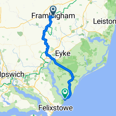
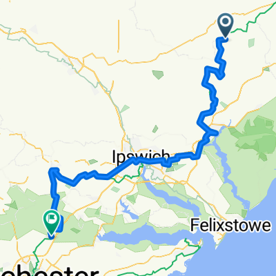
Framlingham Coastal Loop
Un itinéraire vélo au départ de Framlingham, Angleterre, Royaume-Uni.
Vue d'ensemble
À propos du circuit
A nice quick route showing the best Suffolk has to offer starting at Framlingham home of Framlingham Castle and then going to the coast including Thorpeness, Aldeburgh, Snape and Orford. The route then goes past some of Suffolks woodland including Tunstall and Rendlesham Forest bringing you back through Saxmundham and back to Framlingham.
All roads are relatively quiet although the road out of Aldeburgh can get busy especially in summer months. You could also try going back towards Hacheston and Parham. Although this way is slightly more challenging plus the road is slightly quieter as the Hacheston to Framlingham road can get busy.
The only challenging bit is the hills between Framlingham and Saxmundham. You can cut Framlingham out completely and start and end in somewhere like Saxmundham, I only go from Framlingham because I live nearby.
- -:--
- Durée
- 89,3 km
- Distance
- 228 m
- Montée
- 228 m
- Descente
- ---
- Vit. moyenne
- ---
- Altitude max.
Qualité de l’itinéraire
Types de voies et surfaces le long de l’itinéraire
Types de routes
Route fréquentée
63,5 km
(71 %)
Route tranquille
24,1 km
(27 %)
surfaces
Pavé
15,2 km
(17 %)
Asphalte
15,2 km
(17 %)
Indéfini
74,1 km
(83 %)
Continuer avec Bikemap
Utilise, modifie ou télécharge cet itinéraire vélo
Tu veux parcourir Framlingham Coastal Loop ou l’adapter à ton propre voyage ? Voici ce que tu peux faire avec cet itinéraire Bikemap :
Fonctionnalités gratuites
- Enregistre cet itinéraire comme favori ou dans une collection
- Copie et planifie ta propre version de cet itinéraire
- Divise-le en étapes pour créer un tour sur plusieurs jours
- Synchronise ton itinéraire avec Garmin ou Wahoo
Fonctionnalités Premium
Essai gratuit de 3 jours, ou paiement unique. En savoir plus sur Bikemap Premium.
- Navigue sur cet itinéraire sur iOS et Android
- Exporter un fichier GPX / KML de cet itinéraire
- Crée ton impression personnalisée (essaie-la gratuitement)
- Télécharge cet itinéraire pour la navigation hors ligne
Découvre plus de fonctionnalités Premium.
Obtiens Bikemap PremiumDe notre communauté
Framlingham : Autres itinéraires populaires qui commencent ici
 Framlingham Coastal Loop
- Distance
- 89,3 km
- Montée
- 228 m
- Descente
- 228 m
- Emplacement
- Framlingham, Angleterre, Royaume-Uni
 WALK - Framlingham, Dennington, Badingham (11.2 miles)
- Distance
- 18 km
- Montée
- 109 m
- Descente
- 110 m
- Emplacement
- Framlingham, Angleterre, Royaume-Uni
 Woodsford Rides 2019 day 2b
- Distance
- 37,7 km
- Montée
- 146 m
- Descente
- 173 m
- Emplacement
- Framlingham, Angleterre, Royaume-Uni
 2020 Challenge D22
- Distance
- 74,7 km
- Montée
- 285 m
- Descente
- 278 m
- Emplacement
- Framlingham, Angleterre, Royaume-Uni
 Framlingham to Eye Loop
- Distance
- 80,9 km
- Montée
- 161 m
- Descente
- 157 m
- Emplacement
- Framlingham, Angleterre, Royaume-Uni
 Framlingham to Eastbridge
- Distance
- 18,8 km
- Montée
- 75 m
- Descente
- 116 m
- Emplacement
- Framlingham, Angleterre, Royaume-Uni
 High-speed route
- Distance
- 17,7 km
- Montée
- 88 m
- Descente
- 80 m
- Emplacement
- Framlingham, Angleterre, Royaume-Uni
 first leg
- Distance
- 56 619,8 km
- Montée
- 55 m
- Descente
- 93 m
- Emplacement
- Framlingham, Angleterre, Royaume-Uni
Ouvre-la dans l’app