
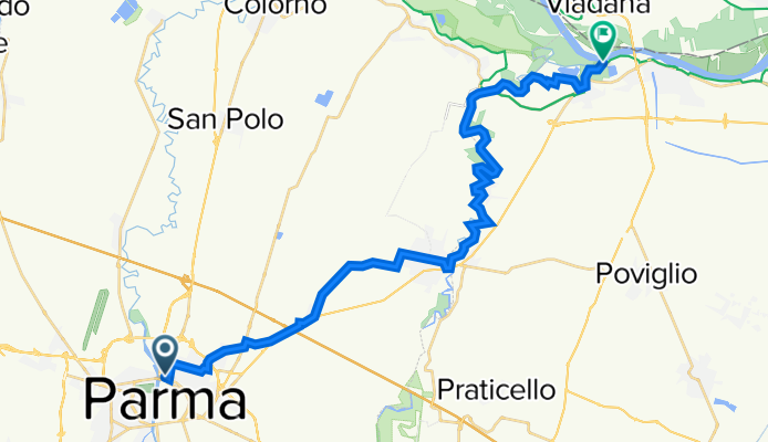
b) 15 PR Ciclovia Parma - Brescello; from Parma to Brescello (river Po)
Un itinéraire vélo au départ de Parme, Émilie-Romagne, Italie.
Vue d'ensemble
À propos du circuit
Percorso sovra-provinciale prevalentemente in sede protetta. La prima parte unisce la città di Parma con Sorbolo sfruttando un recupero di ex ferrovia e una nuova (2021) pista ciclabile a lato strada. Si attraversa l'abitato di Sorbolo poi il fiume Enza su spalliera ciclabile del ponte della ex statale 62 e si segue il fiume su argine ciclabile fino all'abitato di Brscello. L'ultima parte del percorso è posta su argine non ancora stabilizzato. E' possibile altresì arrivare in bici in sicurezza fino alla foce dell'Enza nel fiume Po. Questo ultimo tratto giace anche sulla ciclovie del Po in sponda destra.
Eng
Inter- provincial route mainly in a protected path. The first part combines the city of Parma with Sorbolo by exploiting an ex-railroad track and a new (2021) bike path near the main road. It crosses then the Enza river on the cycle side of the bridge of the former national road 62 and follows the river on cycle embankment until the village of Brescello. The last part of the route is placed on embankment not yet stabilized. It is also possible to arrive by bike safely until the mouth of the Enza river in the Po river. This last stretch also lies on the river Po cycle route on the right bank.
- -:--
- Durée
- 30 km
- Distance
- 13 m
- Montée
- 45 m
- Descente
- ---
- Vit. moyenne
- 57 m
- Altitude max.

Photos de l’itinéraire
 15 PR Ciclovia Parma - Brescello; from Parma to Brescello (river Po) »")
 15 PR Ciclovia Parma - Brescello; from Parma to Brescello (river Po) »")
 15 PR Ciclovia Parma - Brescello; from Parma to Brescello (river Po) »")
 15 PR Ciclovia Parma - Brescello; from Parma to Brescello (river Po) »")
Qualité de l’itinéraire
Types de voies et surfaces le long de l’itinéraire
Types de routes
Route forestière
12,3 km
(41 %)
Piste cyclable
8,7 km
(29 %)
surfaces
Pavé
17,1 km
(57 %)
Non pavé
2,4 km
(8 %)
Asphalte
13,8 km
(46 %)
Pavé (non défini)
3,3 km
(11 %)
Continuer avec Bikemap
Utilise, modifie ou télécharge cet itinéraire vélo
Tu veux parcourir b) 15 PR Ciclovia Parma - Brescello; from Parma to Brescello (river Po) ou l’adapter à ton propre voyage ? Voici ce que tu peux faire avec cet itinéraire Bikemap :
Fonctionnalités gratuites
- Enregistre cet itinéraire comme favori ou dans une collection
- Copie et planifie ta propre version de cet itinéraire
- Synchronise ton itinéraire avec Garmin ou Wahoo
Fonctionnalités Premium
Essai gratuit de 3 jours, ou paiement unique. En savoir plus sur Bikemap Premium.
- Navigue sur cet itinéraire sur iOS et Android
- Exporter un fichier GPX / KML de cet itinéraire
- Crée ton impression personnalisée (essaie-la gratuitement)
- Télécharge cet itinéraire pour la navigation hors ligne
Découvre plus de fonctionnalités Premium.
Obtiens Bikemap PremiumDe notre communauté
Parme : Autres itinéraires populaires qui commencent ici
 Parma-Alberi-Langhirano-Calestano-Parma
- Distance
- 70,7 km
- Montée
- 796 m
- Descente
- 795 m
- Emplacement
- Parme, Émilie-Romagne, Italie
 1 Oct Parma to Reggio Emilia via Montechiarugolo -Montecchio
- Distance
- 46,3 km
- Montée
- 164 m
- Descente
- 158 m
- Emplacement
- Parme, Émilie-Romagne, Italie
 Argini parmensi
- Distance
- 64,4 km
- Montée
- 58 m
- Descente
- 61 m
- Emplacement
- Parme, Émilie-Romagne, Italie
 Parma-Traversetolo-Langhirano-Felino-Parma
- Distance
- 60,5 km
- Montée
- 408 m
- Descente
- 408 m
- Emplacement
- Parme, Émilie-Romagne, Italie
 AA6 anello Parma- Brescello-Colorno
- Distance
- 60,1 km
- Montée
- 99 m
- Descente
- 106 m
- Emplacement
- Parme, Émilie-Romagne, Italie
 A6 Parma- Montechiarugolo -Montecchio - Reggio Emilia e dintorni
- Distance
- 61,3 km
- Montée
- 214 m
- Descente
- 212 m
- Emplacement
- Parme, Émilie-Romagne, Italie
 B4 Parma- Montechiarugolo -Montecchio - Rivalta Re
- Distance
- 56,5 km
- Montée
- 246 m
- Descente
- 210 m
- Emplacement
- Parme, Émilie-Romagne, Italie
 Parma Ciclovia del Sole
- Distance
- 256,4 km
- Montée
- 797 m
- Descente
- 763 m
- Emplacement
- Parme, Émilie-Romagne, Italie
Ouvre-la dans l’app