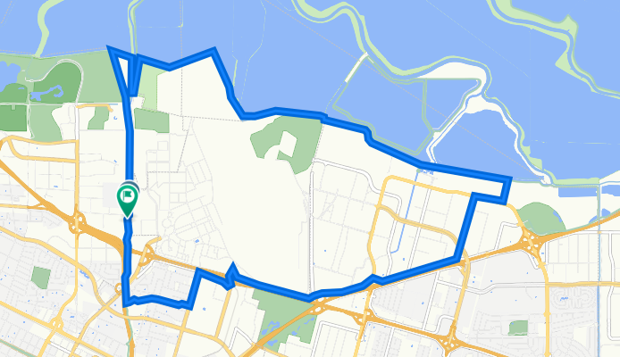
andyabel
andyabel

andyabel

Emplacement
États Unis
Temps sur Bikemap
Membre depuis 03/10/2011

Mes circuits

Sorties planifiées et enregistrées

Collections et randonnées en plusieurs étapes

Découvrir

Mes itinéraires les plus populaires

Palo Alto Baylands Trail

Itinéraire à vélo à Palo Alto, Californie, États Unis

Around Palo Alto Baylands, Airport and Golf Course.
12,8 km
Distance
25 m
Montée
28 m
Descente
Moffett Field Bay Trail returning by Hetch Hetchy Trail
Vélo de ville
andyabel

Moffett Field Bay Trail returning by Hetch Hetchy Trail

Itinéraire à vélo à Mountain View, Californie, États Unis

Follows the Stevens Creek trail from Microsoft to the Bay Trail going round the back of Moffett Field, then returns via Hetch Hetchy Trail.
19,9 km
Distance
25 m
Montée
24 m
Descente

Half Moon Bay to Pillar Point

Itinéraire à vélo à Half Moon Bay, Californie, États Unis

This is just a one-way route. Return the same way.
11,5 km
Distance
44 m
Montée
67 m
Descente

17 Mile Drive Circuit from Wilkie's Inn

Itinéraire à vélo à Pacific Grove, Californie, États Unis

From Wilkie's Inn Cycle down to Lovers Point then cycle along the coast to Cypess Point, then return.
22,5 km
Distance
132 m
Montée
130 m
Descente

Plus d’itinéraires depuis États Unis