
Jednodniowa wycieczka rowerowa z Saint-Michel-de-Maurienne do Huez
Dostosuj własną trasę na podstawie naszego szablonu lub zobacz, jak nasza społeczność najchętniej jeździ z Saint-Michel-de-Maurienne do Huez.
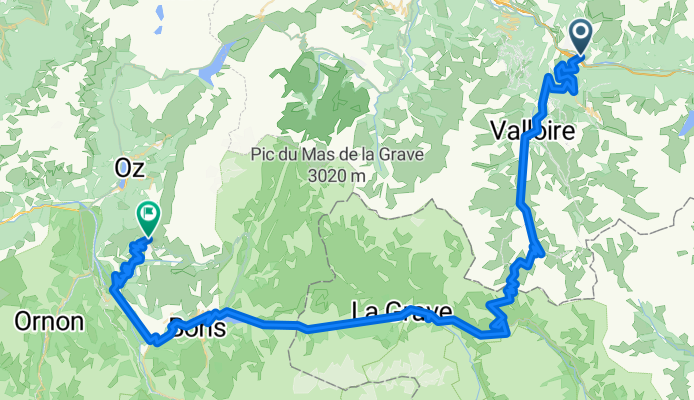
Szablon trasy
Z Saint-Michel-de-Maurienne do Huez

- 9 h 52 min
- Czas
- 77,6 km
- Dystans
- 3993 m
- Przewyższenia
- 3209 m
- Spadek
- 7,9 km/h
- Śr. Prędkość
- 2469 m
- Maks. wysokość
Get ready for a legendary ride! Starting out in Saint-Michel-de-Maurienne, a classic cycling town tucked at the foot of the Alps, you’ll pedal toward Huez – home of the iconic Alpe d’Huez climb, famed for its 21 hairpin bends featured in the Tour de France.
This route packs a punch: around 78 km long, but the real kicker is the climbing—nearly 4000 meters of ascent! You’ll be weaving through quiet mountain roads and hidden alpine paths, so expect some epic scenery (and plenty of chances to catch your breath).
The ride isn’t all smooth sailing, though. About a third is fully paved or asphalt, but much is on quieter, mixed-surface roads, making for an even more adventurous route. Check your tires, bring some snacks, and prepare for big-mountain vibes.
Once in Huez, treat yourself: you’ve just tackled some of the Alps’ finest terrain! This one's for your cycling memory book.
Wspólnota
Najlepsi użytkownicy w tym regionie


Od naszej społeczności
Najlepsze trasy rowerowe z Saint-Michel-de-Maurienne do Huez

Alpentour 2008
Trasa rowerowa w Saint-Michel-de-Maurienne, Owernia-Rodan-Alpy, Francja
- 80,9 km
- Dystans
- 3097 m
- Przewyższenia
- 3082 m
- Spadek

Tour des Irons 1: Telegraph to Alpe d'Huez
Trasa rowerowa w Saint-Michel-de-Maurienne, Owernia-Rodan-Alpy, Francja
- 82,4 km
- Dystans
- 2283 m
- Przewyższenia
- 2288 m
- Spadek

4. Etappe: Saint-Jean-de-Maurienne - Alpe d'Huez - Le Bourg d'Oisans
Trasa rowerowa w Saint-Michel-de-Maurienne, Owernia-Rodan-Alpy, Francja
- 101,9 km
- Dystans
- 2681 m
- Przewyższenia
- 2668 m
- Spadek

Maurienne1
Trasa rowerowa w Saint-Michel-de-Maurienne, Owernia-Rodan-Alpy, Francja
- 90,1 km
- Dystans
- 3666 m
- Przewyższenia
- 2568 m
- Spadek

Tour Alpin 2011 - Etappe 3
Trasa rowerowa w Saint-Michel-de-Maurienne, Owernia-Rodan-Alpy, Francja
- 94,5 km
- Dystans
- 3502 m
- Przewyższenia
- 2396 m
- Spadek
Saint-Michel de Maurienne - Alpe d'Huez
Trasa rowerowa w Saint-Michel-de-Maurienne, Owernia-Rodan-Alpy, Francja
- 95,6 km
- Dystans
- 3345 m
- Przewyższenia
- 2202 m
- Spadek

Saint-Michel-de-Maurienne - L'Alpe d'Huez
Trasa rowerowa w Saint-Michel-de-Maurienne, Owernia-Rodan-Alpy, Francja
- 95,8 km
- Dystans
- 3339 m
- Przewyższenia
- 2208 m
- Spadek

The three Kings
Trasa rowerowa w Saint-Michel-de-Maurienne, Owernia-Rodan-Alpy, Francja
- 93,5 km
- Dystans
- 3256 m
- Przewyższenia
- 2140 m
- Spadek

Alpentour 2008
Trasa rowerowa w Saint-Michel-de-Maurienne, Owernia-Rodan-Alpy, Francja
- 82,2 km
- Dystans
- 2425 m
- Przewyższenia
- 2411 m
- Spadek

Westalpen 3.1
Trasa rowerowa w Saint-Michel-de-Maurienne, Owernia-Rodan-Alpy, Francja
- 104 km
- Dystans
- 2983 m
- Przewyższenia
- 1862 m
- Spadek

Tacx - Alpine Classic 2007
Trasa rowerowa w Saint-Michel-de-Maurienne, Owernia-Rodan-Alpy, Francja
- 98 km
- Dystans
- 3604 m
- Przewyższenia
- 2464 m
- Spadek

3. Galibier and Alpe d'Huez
Trasa rowerowa w Saint-Michel-de-Maurienne, Owernia-Rodan-Alpy, Francja
- 89,1 km
- Dystans
- 3305 m
- Przewyższenia
- 2235 m
- Spadek
Odkryj więcej tras
 Tour Alpin 2011 - Etappe 3
- Dystans
- 94,5 km
- Przewyższenia
- 3502 m
- Spadek
- 2396 m
- Lokalizacja
- Saint-Michel-de-Maurienne, Owernia-Rodan-Alpy, Francja
 Saint-Michel de Maurienne - Alpe d'Huez
- Dystans
- 95,6 km
- Przewyższenia
- 3345 m
- Spadek
- 2202 m
- Lokalizacja
- Saint-Michel-de-Maurienne, Owernia-Rodan-Alpy, Francja
 Saint-Michel-de-Maurienne - L'Alpe d'Huez
- Dystans
- 95,8 km
- Przewyższenia
- 3339 m
- Spadek
- 2208 m
- Lokalizacja
- Saint-Michel-de-Maurienne, Owernia-Rodan-Alpy, Francja
 The three Kings
- Dystans
- 93,5 km
- Przewyższenia
- 3256 m
- Spadek
- 2140 m
- Lokalizacja
- Saint-Michel-de-Maurienne, Owernia-Rodan-Alpy, Francja
 Alpentour 2008
- Dystans
- 82,2 km
- Przewyższenia
- 2425 m
- Spadek
- 2411 m
- Lokalizacja
- Saint-Michel-de-Maurienne, Owernia-Rodan-Alpy, Francja
 Westalpen 3.1
- Dystans
- 104 km
- Przewyższenia
- 2983 m
- Spadek
- 1862 m
- Lokalizacja
- Saint-Michel-de-Maurienne, Owernia-Rodan-Alpy, Francja
 Tacx - Alpine Classic 2007
- Dystans
- 98 km
- Przewyższenia
- 3604 m
- Spadek
- 2464 m
- Lokalizacja
- Saint-Michel-de-Maurienne, Owernia-Rodan-Alpy, Francja
 3. Galibier and Alpe d'Huez
- Dystans
- 89,1 km
- Przewyższenia
- 3305 m
- Spadek
- 2235 m
- Lokalizacja
- Saint-Michel-de-Maurienne, Owernia-Rodan-Alpy, Francja
Trasy z Saint-Michel-de-Maurienne
Jednodniowa wycieczka rowerowa od
Z Saint-Michel-de-Maurienne do Briançon
Szybka przejażdżka rowerowa od
Z Saint-Michel-de-Maurienne do Valloire
Trasy do Huez
Jednodniowa wycieczka rowerowa od
Z Les Deux Alpes do Huez
Jednodniowa wycieczka rowerowa od
Z Gap do Huez