
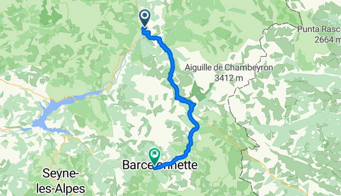
Jednodniowa wycieczka rowerowa z Guillestre do Barcelonnette
Dostosuj własną trasę na podstawie naszego szablonu lub zobacz, jak nasza społeczność najchętniej jeździ z Guillestre do Barcelonnette.
Szablon trasy
Z Guillestre do Barcelonnette

- 5 h 10 min
- Czas
- 60,6 km
- Dystans
- 2851 m
- Przewyższenia
- 2715 m
- Spadek
- 11,7 km/h
- Śr. Prędkość
- 2108 m
- Maks. wysokość
Get ready for a true Alpine adventure! This route takes you from the charming mountain town of Guillestre all the way to Barcelonnette, spanning just over 60 kilometers through the stunning French Alps. Both towns are gateways to the great outdoors—Guillestre sits at the confluence of the Guil and Durance rivers, surrounded by dramatic peaks, while Barcelonnette, with its quirky Mexican villas, is the heart of the Ubaye Valley.
The ride packs in some serious climbing (over 2,800 meters of ascent!), so be prepared for switchbacks, breathtaking views, and the thrill of high-altitude biking—your highest point hits above 2,100 meters. The mix of surfaces (expect paved roads, gravel, and tracks) and mostly quiet roads means you’ll have plenty of peace and epic vistas. It’s a physically demanding ride, but the scenery, isolation, and sense of accomplishment are absolutely worth it.
Once you roll into Barcelonnette, treat yourself to a pastry and soak up the festive Alpine atmosphere. This route is perfect for seasoned cyclists looking for a challenge—and those who love their landscapes rugged and unspoiled!
Wspólnota
Najlepsi użytkownicy w tym regionie


Od naszej społeczności
Najlepsze trasy rowerowe z Guillestre do Barcelonnette

FA10 Barcelonnette
Trasa rowerowa w Guillestre, Prowansja-Alpy-Lazurowe Wybrzeże, Francja
- 51,4 km
- Dystans
- 1167 m
- Przewyższenia
- 985 m
- Spadek

Route des Grandes Alpes - Guillestre - Col de la Cayolle
Trasa rowerowa w Guillestre, Prowansja-Alpy-Lazurowe Wybrzeże, Francja
- 86,9 km
- Dystans
- 2257 m
- Przewyższenia
- 1449 m
- Spadek

Stäfa - Tarifa Stage #6 Guillestre - Cime de la Bonette - Barcelonnette
Trasa rowerowa w Guillestre, Prowansja-Alpy-Lazurowe Wybrzeże, Francja
- 94,7 km
- Dystans
- 2641 m
- Przewyższenia
- 2508 m
- Spadek

25e Dag Tour de France
Trasa rowerowa w Guillestre, Prowansja-Alpy-Lazurowe Wybrzeże, Francja
- 53,4 km
- Dystans
- 1717 m
- Przewyższenia
- 1545 m
- Spadek

Allos - Guillestre
Trasa rowerowa w Guillestre, Prowansja-Alpy-Lazurowe Wybrzeże, Francja
- 229,7 km
- Dystans
- 5909 m
- Przewyższenia
- 5479 m
- Spadek

TdF - 5
Trasa rowerowa w Guillestre, Prowansja-Alpy-Lazurowe Wybrzeże, Francja
- 55,3 km
- Dystans
- 1545 m
- Przewyższenia
- 964 m
- Spadek
Provence 2006 - den druhý
Trasa rowerowa w Guillestre, Prowansja-Alpy-Lazurowe Wybrzeże, Francja
- 58,1 km
- Dystans
- 1988 m
- Przewyższenia
- 1680 m
- Spadek

9eme étape
Trasa rowerowa w Guillestre, Prowansja-Alpy-Lazurowe Wybrzeże, Francja
- 50,8 km
- Dystans
- 1129 m
- Przewyższenia
- 1007 m
- Spadek

Cols Cayolle, Champs, Allos
Trasa rowerowa w Guillestre, Prowansja-Alpy-Lazurowe Wybrzeże, Francja
- 206,6 km
- Dystans
- 7829 m
- Przewyższenia
- 8037 m
- Spadek

Guillestre-Risoul-Vars-Barcelonette
Trasa rowerowa w Guillestre, Prowansja-Alpy-Lazurowe Wybrzeże, Francja
- 81,1 km
- Dystans
- 2107 m
- Przewyższenia
- 1931 m
- Spadek

2012-08-15 Guilestre-Col De Vars-Barcelonnette
Trasa rowerowa w Guillestre, Prowansja-Alpy-Lazurowe Wybrzeże, Francja
- 59,1 km
- Dystans
- 1133 m
- Przewyższenia
- 1128 m
- Spadek

Queyras --> Chalet
Trasa rowerowa w Guillestre, Prowansja-Alpy-Lazurowe Wybrzeże, Francja
- 88,5 km
- Dystans
- 1691 m
- Przewyższenia
- 1946 m
- Spadek
Odkryj więcej tras
 Allos - Guillestre
- Dystans
- 229,7 km
- Przewyższenia
- 5909 m
- Spadek
- 5479 m
- Lokalizacja
- Guillestre, Prowansja-Alpy-Lazurowe Wybrzeże, Francja
 TdF - 5
- Dystans
- 55,3 km
- Przewyższenia
- 1545 m
- Spadek
- 964 m
- Lokalizacja
- Guillestre, Prowansja-Alpy-Lazurowe Wybrzeże, Francja
 Provence 2006 - den druhý
- Dystans
- 58,1 km
- Przewyższenia
- 1988 m
- Spadek
- 1680 m
- Lokalizacja
- Guillestre, Prowansja-Alpy-Lazurowe Wybrzeże, Francja
 9eme étape
- Dystans
- 50,8 km
- Przewyższenia
- 1129 m
- Spadek
- 1007 m
- Lokalizacja
- Guillestre, Prowansja-Alpy-Lazurowe Wybrzeże, Francja
 Cols Cayolle, Champs, Allos
- Dystans
- 206,6 km
- Przewyższenia
- 7829 m
- Spadek
- 8037 m
- Lokalizacja
- Guillestre, Prowansja-Alpy-Lazurowe Wybrzeże, Francja
 Guillestre-Risoul-Vars-Barcelonette
- Dystans
- 81,1 km
- Przewyższenia
- 2107 m
- Spadek
- 1931 m
- Lokalizacja
- Guillestre, Prowansja-Alpy-Lazurowe Wybrzeże, Francja
 2012-08-15 Guilestre-Col De Vars-Barcelonnette
- Dystans
- 59,1 km
- Przewyższenia
- 1133 m
- Spadek
- 1128 m
- Lokalizacja
- Guillestre, Prowansja-Alpy-Lazurowe Wybrzeże, Francja
 Queyras --> Chalet
- Dystans
- 88,5 km
- Przewyższenia
- 1691 m
- Spadek
- 1946 m
- Lokalizacja
- Guillestre, Prowansja-Alpy-Lazurowe Wybrzeże, Francja
Trasy z Guillestre
Jednodniowa wycieczka rowerowa od
Z Guillestre do Jausiers
Jednodniowa wycieczka rowerowa od
Z Guillestre do Huez
Trasy do Barcelonnette
Jednodniowa wycieczka rowerowa od
Z Briançon do Barcelonnette