
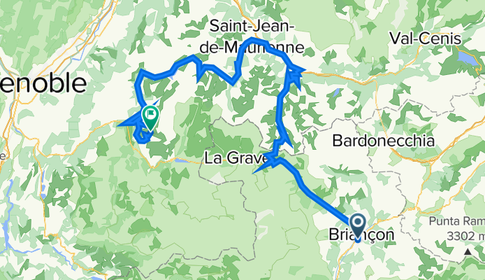
Szablon trasy
Z Briançon do Huez

- 6 h 23 min
- Czas
- 82,4 km
- Dystans
- 2922 m
- Przewyższenia
- 2725 m
- Spadek
- 12,9 km/h
- Śr. Prędkość
- 2061 m
- Maks. wysokość
This route is an absolute classic for fans of dramatic mountain scenery! Starting in Briançon, France’s highest city at 1,326 meters, you’ll roll out beneath ancient Vauban fortifications before heading into legendary cycling territory. The ride to Huez covers about 82 km with some serious climbing—almost 3,000 meters of ascent! Make sure your legs and brakes are up for it.
You’ll be riding mostly on paved roads, but expect a patchwork mix, and keep an eye out for some gravel and less-maintained sections (good tires recommended). The route winds through the heart of the French Alps, likely taking you over famous passes like Col du Lautaret and then up the iconic bends to Alpe d’Huez—known for their history in the Tour de France.
Your destination, Huez, towers high above the Oisans valley and is synonymous with epic road cycling. This isn’t a ride for the faint of heart, but every pedal stroke is rewarded with jaw-dropping views, remote mountain peace, and a dose of cycling bragging rights. Don’t forget your camera and plenty of snacks!
Wspólnota
Najlepsi użytkownicy w tym regionie


Od naszej społeczności
Najlepsze trasy rowerowe z Briançon do Huez

Francia Alpok 09 vándor
Trasa rowerowa w Briançon, Prowansja-Alpy-Lazurowe Wybrzeże, Francja
- 69,8 km
- Dystans
- 824 m
- Przewyższenia
- 1464 m
- Spadek

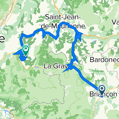
briançon - galibier - télégraphe - croix de fer - glandon
Trasa rowerowa w Briançon, Prowansja-Alpy-Lazurowe Wybrzeże, Francja
- 146,4 km
- Dystans
- 3192 m
- Przewyższenia
- 3679 m
- Spadek

Briançon Lautaret Bourd D'Oisans Alpe d'Huez
Trasa rowerowa w Briançon, Prowansja-Alpy-Lazurowe Wybrzeże, Francja
- 78 km
- Dystans
- 2040 m
- Przewyższenia
- 1445 m
- Spadek

ラルプへの道
Trasa rowerowa w Briançon, Prowansja-Alpy-Lazurowe Wybrzeże, Francja
- 68,8 km
- Dystans
- 1198 m
- Przewyższenia
- 1745 m
- Spadek

Briançon - Alpe d'Huez
Trasa rowerowa w Briançon, Prowansja-Alpy-Lazurowe Wybrzeże, Francja
- 215,5 km
- Dystans
- 5589 m
- Przewyższenia
- 4977 m
- Spadek

Dia 11- Briancon - Col de Lautaret - Bourg d'Oisans
Trasa rowerowa w Briançon, Prowansja-Alpy-Lazurowe Wybrzeże, Francja
- 67,1 km
- Dystans
- 987 m
- Przewyższenia
- 1554 m
- Spadek

Francia 2018-2 Briancon-Le Bourg-d'Oisans
Trasa rowerowa w Briançon, Prowansja-Alpy-Lazurowe Wybrzeże, Francja
- 123,5 km
- Dystans
- 2587 m
- Przewyższenia
- 3203 m
- Spadek

BRIANSON - ALP DE HUEZ
Trasa rowerowa w Briançon, Prowansja-Alpy-Lazurowe Wybrzeże, Francja
- 88,1 km
- Dystans
- 2058 m
- Przewyższenia
- 1787 m
- Spadek

8. Etappe 2.7. Briancon - L'Alpe d'Huez
Trasa rowerowa w Briançon, Prowansja-Alpy-Lazurowe Wybrzeże, Francja
- 104,2 km
- Dystans
- 2831 m
- Przewyższenia
- 2248 m
- Spadek

EDT 2022
Trasa rowerowa w Briançon, Prowansja-Alpy-Lazurowe Wybrzeże, Francja
- 168 km
- Dystans
- 5387 m
- Przewyższenia
- 4751 m
- Spadek
briançon - galibier - télégraphe - croix de fer - alphe d'huez - glandon
Trasa rowerowa w Briançon, Prowansja-Alpy-Lazurowe Wybrzeże, Francja
- 167,5 km
- Dystans
- 4214 m
- Przewyższenia
- 3563 m
- Spadek

briancon lautaret - sarenne
Trasa rowerowa w Briançon, Prowansja-Alpy-Lazurowe Wybrzeże, Francja
- 105,1 km
- Dystans
- 3051 m
- Przewyższenia
- 3528 m
- Spadek
Odkryj więcej tras
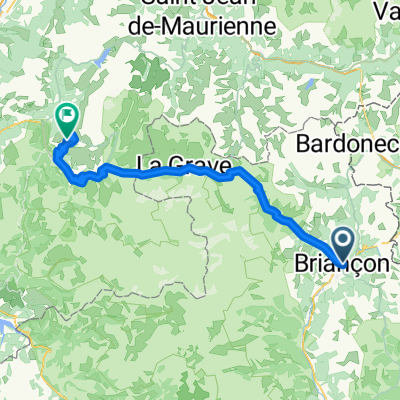
 Briançon - Alpe d'Huez
- Dystans
- 215,5 km
- Przewyższenia
- 5589 m
- Spadek
- 4977 m
- Lokalizacja
- Briançon, Prowansja-Alpy-Lazurowe Wybrzeże, Francja
 Dia 11- Briancon - Col de Lautaret - Bourg d'Oisans
- Dystans
- 67,1 km
- Przewyższenia
- 987 m
- Spadek
- 1554 m
- Lokalizacja
- Briançon, Prowansja-Alpy-Lazurowe Wybrzeże, Francja
 Francia 2018-2 Briancon-Le Bourg-d'Oisans
- Dystans
- 123,5 km
- Przewyższenia
- 2587 m
- Spadek
- 3203 m
- Lokalizacja
- Briançon, Prowansja-Alpy-Lazurowe Wybrzeże, Francja
 BRIANSON - ALP DE HUEZ
- Dystans
- 88,1 km
- Przewyższenia
- 2058 m
- Spadek
- 1787 m
- Lokalizacja
- Briançon, Prowansja-Alpy-Lazurowe Wybrzeże, Francja
 8. Etappe 2.7. Briancon - L'Alpe d'Huez
- Dystans
- 104,2 km
- Przewyższenia
- 2831 m
- Spadek
- 2248 m
- Lokalizacja
- Briançon, Prowansja-Alpy-Lazurowe Wybrzeże, Francja
 EDT 2022
- Dystans
- 168 km
- Przewyższenia
- 5387 m
- Spadek
- 4751 m
- Lokalizacja
- Briançon, Prowansja-Alpy-Lazurowe Wybrzeże, Francja
 briançon - galibier - télégraphe - croix de fer - alphe d'huez - glandon
- Dystans
- 167,5 km
- Przewyższenia
- 4214 m
- Spadek
- 3563 m
- Lokalizacja
- Briançon, Prowansja-Alpy-Lazurowe Wybrzeże, Francja
 briancon lautaret - sarenne
- Dystans
- 105,1 km
- Przewyższenia
- 3051 m
- Spadek
- 3528 m
- Lokalizacja
- Briançon, Prowansja-Alpy-Lazurowe Wybrzeże, Francja
Trasy z Briançon
Jednodniowa wycieczka rowerowa od
Z Briançon do Guillestre
Jednodniowa wycieczka rowerowa od
Z Briançon do Barcelonnette
Rowerowa od
Z Briançon do Le Monêtier-les-Bains
Rowerowa od
Z Briançon do Villeneuve
Trasy do Huez
Jednodniowa wycieczka rowerowa od
Z Guillestre do Huez
Jednodniowa wycieczka rowerowa od
Z Les Deux Alpes do Huez