

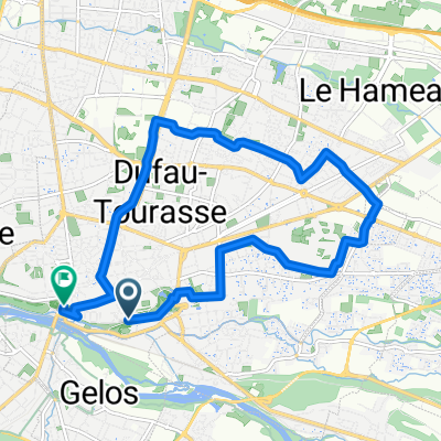
Ride Day 7—15 Sept 2005—64000 Pau to 64400 Oloron-Ste-Marie
Trasa rowerowa rozpoczynająca się w Pau, Nouvelle-Aquitaine, Francja.
Przegląd
O tej trasie
Moja żona, jako nawigatorka, zaplanowała bardzo okrężną trasę, aby odległość około 20 mil w linii prostej z Pau do Oloron-Ste-Marie została powiększona do ponad 60 mil. Obejmuje prawie wszystkie drogi oznaczone "zielonym" kolorem na mapie między Pau a Oloron-Ste-Marie. Z wyjątkiem D27, która była przeceniana przez swoje zielone oznaczenie (fajna jazda, ale płaska z mało inspirującym terenem), wszystkie drogi były doskonałe. I ponieważ wkrótce wkraczaliśmy w stopnie Pirenejów, czasami mogliśmy zobaczyć piękną ścianę lekko mglistych gór z wierzchołków niektórych z tych wzgórz. Na niektórych odcinkach D2 i D9, dwóch dróg o większym natężeniu ruchu, były częściowo rozsądne pobocza lub ścieżki rowerowe.
- -:--
- Czas
- 103,4 km
- Dystans
- 824 m
- Przewyższenia
- 806 m
- Spadek
- ---
- Śr. Prędkość
- ---
- Maks. wysokość

Jakość trasy
Typy dróg i nawierzchnie na trasie
Typy dróg
Droga
31 km
(30 %)
Spokojna droga
3,1 km
(3 %)
Niezdefiniowany
69,3 km
(67 %)
Powierzchnie
Utwardzona
75,5 km
(73 %)
Asfalt
75,5 km
(73 %)
Niezdefiniowany
27,9 km
(27 %)
Kontynuuj z Bikemap
Użyj, edytuj lub pobierz tę trasę rowerową
Chcesz przejechać trasę Ride Day 7—15 Sept 2005—64000 Pau to 64400 Oloron-Ste-Marie lub dostosować ją do swojej wycieczki? Oto, co możesz zrobić z tą trasą na Bikemap:
Darmowe funkcje
- Zapisz tę trasę jako ulubioną lub w kolekcji
- Skopiuj i zaplanuj swoją wersję tej trasy
- Podziel trasę na etapy, aby utworzyć kilkudniową wycieczkę
- Synchronizuj swoją trasę z Garminem lub Wahoo
Funkcje Premium
3 dni bezpłatnej wersji próbnej lub jednorazowa opłata. Dowiedz się więcej o Bikemap Premium.
- Nawiguj po tej trasie na iOS i Androidzie
- Eksportuj plik GPX / KML tej trasy
- Stwórz swój własny wydruk (wypróbuj za darmo)
- Pobierz tę trasę do nawigacji offline
Odkryj więcej funkcji Premium.
Uzyskaj Bikemap PremiumOd naszej społeczności
Pau: Inne popularne trasy rozpoczynające się tutaj
 Par Aubertin
- Dystans
- 44,5 km
- Przewyższenia
- 474 m
- Spadek
- 474 m
- Lokalizacja
- Pau, Nouvelle-Aquitaine, Francja
 ballade soir niv1
- Dystans
- 43,1 km
- Przewyższenia
- 131 m
- Spadek
- 130 m
- Lokalizacja
- Pau, Nouvelle-Aquitaine, Francja
 My tdf etape 11
- Dystans
- 176,6 km
- Przewyższenia
- 4014 m
- Spadek
- 2450 m
- Lokalizacja
- Pau, Nouvelle-Aquitaine, Francja
 De Boulevard Tourasse 38, Pau à Rue Berlioz 7, Pau
- Dystans
- 22,3 km
- Przewyższenia
- 394 m
- Spadek
- 441 m
- Lokalizacja
- Pau, Nouvelle-Aquitaine, Francja
 De Place Georges Clemenceau à Place Mulot
- Dystans
- 12,3 km
- Przewyższenia
- 50 m
- Spadek
- 121 m
- Lokalizacja
- Pau, Nouvelle-Aquitaine, Francja
 Von Pau bis Biarritz
- Dystans
- 148,8 km
- Przewyższenia
- 1132 m
- Spadek
- 1294 m
- Lokalizacja
- Pau, Nouvelle-Aquitaine, Francja
 17. Samatan / Pau
- Dystans
- 200,3 km
- Przewyższenia
- 4523 m
- Spadek
- 4113 m
- Lokalizacja
- Pau, Nouvelle-Aquitaine, Francja
 Championnat du Monde Cycliste a Pau (lol)
- Dystans
- 15,5 km
- Przewyższenia
- 225 m
- Spadek
- 229 m
- Lokalizacja
- Pau, Nouvelle-Aquitaine, Francja
Otwórz ją w aplikacji