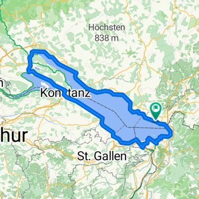
bodensee day 1
- 71,3 km
- 266 m
- 294 m
- Bodolz, Bawaria, Niemcy
Trasa rowerowa rozpoczynająca się w Bodolz, Bawaria, Niemcy.
Przegląd
The cycling route begins in the town of Potsdam and takes you through a mix of asphalt and unpaved paths. The ride mostly follows quiet streets, but you'll also encounter small forests and a forest road. The route is mostly paved, but there are some stretches of gravel and dirt. As you ride, you'll ascend gradually, with the highest point reached around Griebnitzsee at 577 meters. After that, it's mostly downhill. The route is relatively flat, with only a few small hills and descents. The total distance is around 37 kilometres, and the ascent is just 568 metres, making it a manageable ride for most cyclists.
Wygenerowane przez AI
utworzono 1 miesiąc temu temu
Jakość trasy
Spokojna droga
17,2 km
46 %
Droga
7,5 km
20 %
Utwardzona
34,4 km
(92 %)
Nieutwardzona
3 km
(8 %)
Asfalt
34,4 km
92 %
Żwir
1,9 km
5 %
Kontynuuj z Bikemap
Chcesz przejechać trasę Wasserburg - Tettnang lub dostosować ją do swojej wycieczki? Oto, co możesz zrobić z tą trasą na Bikemap:
3 dni bezpłatnej wersji próbnej lub jednorazowa opłata. Dowiedz się więcej o Bikemap Premium.
Odkryj więcej funkcji Premium.
Uzyskaj Bikemap PremiumOd naszej społeczności
Otwórz ją w aplikacji