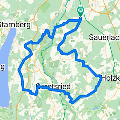
Flandernrundfahrt
- 90,8 km
- 1029 m
- 1024 m
- Oberhaching, Bawaria, Niemcy
Trasa rowerowa rozpoczynająca się w Oberhaching, Bawaria, Niemcy.
Przegląd
Begin your ride at the charming Kugler Alm Weg 1, Oberhaching, and enjoy a pleasant journey through the scenic landscapes of the area. The route is mostly paved, offering a smooth and comfortable ride with a few sections of well-maintained paths and quiet streets. You'll encounter a mix of flat and gently rolling terrain, with a moderate ascent and descent throughout the journey. The route is well-connected to the local bike network, making it an ideal choice for both casual cyclists and those looking to explore the surrounding area. The overall distance of the route is approximately ten kilometres, with a total elevation gain of around twelve metres and a descent of fifty metres. The maximum elevation reached is fifty-eight-seven metres, providing a nice challenge for cyclists with varying fitness levels. The route is well-marked and easy to follow, making it a great option for those looking to explore the area at their own pace.
Wygenerowane przez AI
utworzono 1 miesiąc temu temu
Jakość trasy
Ścieżka
8,3 km
78 %
Spokojna droga
1,9 km
18 %
Utwardzona
9,2 km
(86 %)
Nieutwardzona
1,1 km
(10 %)
Asfalt
9 km
84 %
Żwir
0,9 km
8 %
Kontynuuj z Bikemap
Chcesz przejechać trasę Kugleralm to Home lub dostosować ją do swojej wycieczki? Oto, co możesz zrobić z tą trasą na Bikemap:
3 dni bezpłatnej wersji próbnej lub jednorazowa opłata. Dowiedz się więcej o Bikemap Premium.
Odkryj więcej funkcji Premium.
Uzyskaj Bikemap PremiumOd naszej społeczności
Otwórz ją w aplikacji