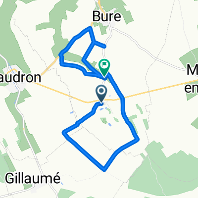
0
- 65,9 km
- 601 m
- 685 m
- Gondrecourt-le-Château, Grand Est, Francja
Trasa rowerowa rozpoczynająca się w Gondrecourt-le-Château, Grand Est, Francja.
Przegląd
<div> <table border="0" cellpadding="0" cellspacing="0" style="width: 618px;" width="619"> <colgroup> <col /> <col /> <col /> <col /> <col span="4" /> <col /> </colgroup> <tbody> <tr height="21"> <td height="21" style="height:21px;width:34px;"> 4,0</td> <td style="width:34px;"> 4,0</td> <td colspan="4" style="width:226px;"> Horville-en-Ornois (D32)</td> <td style="width:64px;"> </td> <td style="width:64px;"> </td> <td style="width:194px;"> </td> </tr> <tr height="21"> <td height="21" style="height:21px;width:34px;"> 9,0</td> <td style="width:34px;"> 5,0</td> <td colspan="7"> Chassey-Beaupré (D32 am Wasserturm geradeaus D32a) </td> </tr> <tr height="21"> <td height="21" style="height:21px;width:34px;"> 12,0</td> <td style="width:34px;"> 3,0</td> <td colspan="7"> Cirfontaines-en-Ornois (D115 - links abbiegen!!! prima)</td> </tr> <tr height="21"> <td height="21" style="height:21px;width:34px;"> 17,0</td> <td style="width:34px;"> 5,0</td> <td colspan="4"> Harméville (auf D115 bleiben)</td> <td> </td> <td> </td> <td> </td> </tr> <tr height="21"> <td height="21" style="height:21px;width:34px;"> 19,0</td> <td style="width:34px;"> 2,0</td> <td colspan="5"> Soulaincourt- geradeaus --> Saily (D115)</td> <td> </td> <td> </td> </tr> <tr height="21"> <td height="21" style="height:21px;width:34px;"> 23,0</td> <td style="width:34px;"> 4,0</td> <td colspan="2"> Sailly (D115)</td> <td> </td> <td> </td> <td> </td> <td> </td> <td> </td> </tr> <tr height="21"> <td height="21" style="height:21px;width:34px;"> 25,0</td> <td style="width:34px;"> 2,0</td> <td colspan="6"> Noncourt-sur-le-Rongeant (D115--> rechts D427)</td> <td> </td> </tr> <tr height="21"> <td height="21" style="height:21px;width:34px;"> 27,0</td> <td style="width:34px;"> 2,0</td> <td colspan="3"> Poissons (D427)</td> <td> </td> <td> </td> <td> </td> <td> </td> </tr> <tr height="21"> <td height="21" style="height:21px;width:34px;"> 32,0</td> <td style="width:34px;"> 5,0</td> <td colspan="7"> SuzanneCourt (D427--> links abbiegen (Heinecken-Schild) !!!)</td> </tr> <tr height="21"> <td height="21" style="height:21px;width:34px;"> 32,3</td> <td style="width:34px;"> 0,3</td> <td colspan="7"> dann Ortsausgang links halten(schlechte Wegstrecke)</td> </tr> <tr height="21"> <td height="21" style="height:21px;width:34px;"> 34,0</td> <td style="width:34px;"> 1,7</td> <td colspan="4"> bis zur D60-dort wieder links</td> <td> </td> <td> </td> <td> </td> </tr> <tr height="22"> <td height="22" style="height:22px;width:34px;"> 35,5</td> <td style="width:34px;"> 1,5</td> <td colspan="2"> Joinville</td> <td> </td> <td> </td> <td> </td> <td> </td> <td> </td> </tr> </tbody> </table> <table border="0" cellpadding="0" cellspacing="0" style="width:618px;" width="619"> <colgroup> <col /> <col /> <col /> <col /> <col span="4" /> <col /> </colgroup> <tbody> </tbody> </table> </div>
D115 scheint eine super-Strecke zu sein!!! leicht ansteigend bis km 11 (100 m auf 10 km) abschüssig bis km 19 1,5 km steil (312hm-->365 hm)<br /> bei km 19 ab km 21 nur noch bergab bis zum Ziel Hotel: Le Val du Roy 22, rue du Valleroy<br /> 52300 Joinville<br /> Telefon +33607554367utworzono 11 lat temu temu
Jakość trasy
Droga
16,1 km
45 %
Spokojna droga
3,2 km
9 %
Utwardzona
26,4 km
(74 %)
Nieutwardzona
1,4 km
(4 %)
Asfalt
26,4 km
74 %
Żwir
1,1 km
3 %
Kontynuuj z Bikemap
Chcesz przejechać trasę Camino 2015 4b Gendrecourt-le-Chateau nach Joinville lub dostosować ją do swojej wycieczki? Oto, co możesz zrobić z tą trasą na Bikemap:
3 dni bezpłatnej wersji próbnej lub jednorazowa opłata. Dowiedz się więcej o Bikemap Premium.
Odkryj więcej funkcji Premium.
Uzyskaj Bikemap PremiumOd naszej społeczności
Otwórz ją w aplikacji