
Bike Across Canada Route Network
A collection of 118 cycling routes, created by Trans Canada Bike Route.
- 118
- Routes
- -:--
- Duration
- 10,577.4 km
- Distance
- ---
- Avg. speed
- 34,230 m
- Ascent
- 34,942 m
- Descent
About this collection
You can download the full GPX file of the network here https://www.facebook.com/groups/bikeacrosscanada/permalink/1909719059097371/
Created by


1of12 BC - 13a Cranbrook, BC to Fernie, BC (Raging Elk Hostel) 103km
Cycling route in Cranbrook, British Columbia, Canada
- 102.6 km
- Distance
- 379 m
- Ascent
- 297 m
- Descent

1of12 BC - 12a Creston, BC to Cranbrook, BC (Mount Baker RV Park & Tenting) 108km
Cycling route in Creston, British Columbia, Canada
- 108.5 km
- Distance
- 606 m
- Ascent
- 272 m
- Descent

1of12 BC - 03e Hope, BC to Boston Bar, BC (Canyon Alpine RV Park and Campground) 73km
Cycling route in
- 77.1 km
- Distance
- 690 m
- Ascent
- 564 m
- Descent
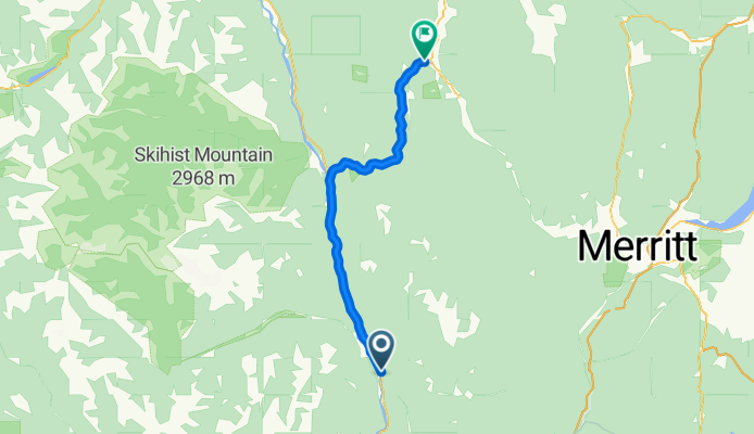
1of12 BC - 04e Boston Bar, BC to Spences Bridge, BC (Acacia Grove RV Park & Cabins) 77km
Cycling route in
- 77 km
- Distance
- 796 m
- Ascent
- 760 m
- Descent

1of12 BC - 05e Spences Bridge, BC to Cache Creek, BC (Brookside Campsite) 49km
Cycling route in
- 48.8 km
- Distance
- 495 m
- Ascent
- 228 m
- Descent

1of12 BC - 06e Cache Creek, BC to Kamloops, BC (Silver Sage Trailer Park) 87km
Cycling route in Cache Creek, British Columbia, Canada
- 86.9 km
- Distance
- 836 m
- Ascent
- 990 m
- Descent

1of12 BC - 07e Kamloops, BC to Salmon Arm, BC (Pierre's Point Campground) 102km
Cycling route in Kamloops, British Columbia, Canada
- 102.2 km
- Distance
- 442 m
- Ascent
- 429 m
- Descent
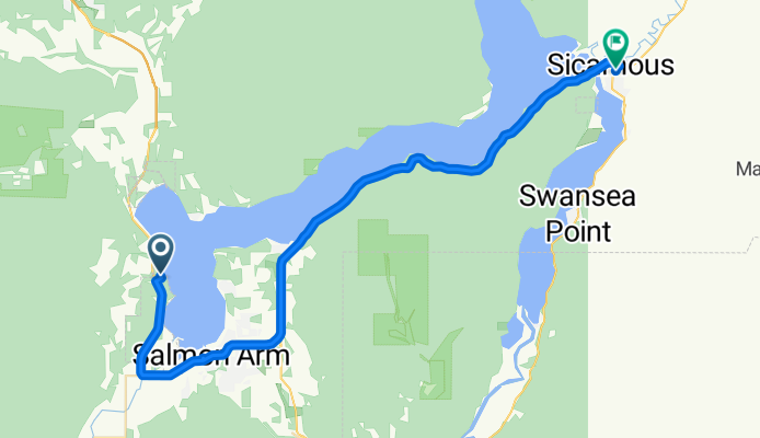
1of12 BC - 08e Salmon Arm, BC to Sicamous, BC (Paradise Motel) 41km
Cycling route in Salmon Arm, British Columbia, Canada
- 40.6 km
- Distance
- 384 m
- Ascent
- 390 m
- Descent

6of12 SouthCentralON - 05a South Baymouth, ON to Owen Sound, ON (Kelso Beach Campground) + ferry 154km
Cycling route in
- 154.7 km
- Distance
- 194 m
- Ascent
- 196 m
- Descent

6of12 SouthCentralON - 06a Owen Sound, ON to Orangeville, ON (Orangeville Motel) 110km
Cycling route in Owen Sound, Ontario, Canada
- 110.4 km
- Distance
- 453 m
- Ascent
- 213 m
- Descent

6of12 SouthCentralON - 07a Orangeville, ON to Brampton, ON (Indian Line Campground) 55km
Cycling route in Orangeville, Ontario, Canada
- 54.9 km
- Distance
- 90 m
- Ascent
- 343 m
- Descent

6of12 SouthCentralON - 8a Brampton, ON to Scarborough, ON (Glen Rouge Campground) 73km
Cycling route in Etobicoke, Ontario, Canada
- 73.3 km
- Distance
- 200 m
- Ascent
- 280 m
- Descent
All routes on the map
You can open and navigate all the routes in the Bikemap app for iOS and Android or continue on web to see all details and routes on the map.