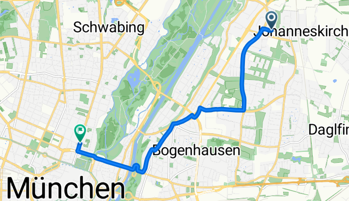
Wie Radfahren in Bogenhausen aussehen könnte.
Wie Radfahren in München aussehen könnte.

Kurze Fahrt mit dem Fahrrad von Bogenhausen nach München

Erstelle deine eigene Route auf der Grundlage unserer Vorlage oder lass dich inspirieren, wie unsere Nutzer am liebsten von Bogenhausen nach München radeln.

Routenvorlage

Bogenhausen nach München

19 min
Dauer
4,6 km
Distanz
24 m
Aufstieg
20 m
Abstieg
14,4 km/h
Ø-Tempo
528 m
Max. Höhe

Starte deine Fahrt im charmanten Viertel Bogenhausen, einem gehobenen Stadtteil, der für seine elegante Architektur und malerischen Spaziergänge entlang der Isar bekannt ist. Du wirst etwas mehr als 4,6 Kilometer radeln, was eine perfekte kurze und schöne Fahrt ist, um die Beine zu vertreten.

Die Route verläuft größtenteils reibungslos mit einer Mischung aus Asphalt und einigen Pflastersteinen, also kannst du eine einfache Fahrt mit sanften Steigungen von etwa 24 Metern Höhenunterschied erwarten. Es ist eine ziemlich entspannte Fahrt, da fast die Hälfte der Strecke ein eigener Radweg und ruhige Straßen sind, was sie perfekt macht, um eine gemütliche Radtour ohne viel Verkehrsstress zu genießen.

Wenn du dich in Richtung Zentrum von München bewegst, halte Ausschau nach dem lebhaften Stadtmitte-Bereich, wo historischer Charme auf modernen Trubel trifft. München selbst ist eine Stadt voller Kultur, mit allem von Biergärten bis hin zu Kunstmuseen, also ist es ein großartiger Zielpunkt, um noch ein bisschen zu Fuß zu erkunden oder eine herzhaft bayerische Mahlzeit zu genießen.

Egal ob du Einheimischer bist oder nur zu Besuch, diese Fahrt von Bogenhausen nach München ist eine lockere Tour, die dir genau die richtige Mischung aus Bewegung und Sightseeing bietet!

Community

Top-Mitglieder in dieser Region

Von unserer Community

Die besten Fahrradrouten von Bogenhausen nach München

1

Von der Münchner Freiheit zum Olympiapark

Fahrradtour in Bogenhausen, Bayern, Bundesrepublik Deutschland

Absolut entspannte Route von der Münchner Freiheit quer durch Schwabing über eine Fahrradstraße, die am Ende direkt in einen gemischten, aber breiten Fußgängerweg übergeht. Dieser mündet am Ackermannbogen in einer Brücke in den Olympiapark hinein auf einen der Hauptwege. Imprinzip immer geradeaus (2 Ampelkreuzungen).
3,8 km
Distanz
17 m
Aufstieg
10 m
Abstieg
München - Abendrunde 75
RennradBefestigt
4

München - Abendrunde 75

Fahrradtour in Bogenhausen, Bayern, Bundesrepublik Deutschland

76 km
Distanz
359 m
Aufstieg
370 m
Abstieg
Isar + Münchner Norden
MTBBefestigtUnbefestigtSchotter
2

Isar + Münchner Norden

Fahrradtour in Bogenhausen, Bayern, Bundesrepublik Deutschland

Entlang der Isar raus aus München und im Norden etwas übers Land, bevor es wieder an der Isar entlang zurück geht.
60,3 km
Distanz
62 m
Aufstieg
77 m
Abstieg
0

München a la Jan

Fahrradtour in Bogenhausen, Bayern, Bundesrepublik Deutschland

10,6 km
Distanz
92 m
Aufstieg
74 m
Abstieg
Innstraße 16 - Oskar-von-Miller-Ring 20
Befestigt
1

Innstraße 16 - Oskar-von-Miller-Ring 20

Fahrradtour in Bogenhausen, Bayern, Bundesrepublik Deutschland

<table class="directions-table " border="0" cellspacing="0" cellpadding="0" width="100%"> <tbody> <tr> <td class="directions-line directions-line-first" style="vertical-align: middle;"><img src="images/start.png" alt="" /></td> <td class="directions-line" colspan="2">Innstraße 16, 81679 München, Deutschland</td> </tr> <tr> <td class="directions-line directions-line-first">1.</td> <td class="directions-line">Richtung West auf Innstraße</td> <td class="directions-line directions-line-last">43 m</td> </tr> <tr> <td class="directions-line directions-line-first">2.</td> <td class="directions-line">Bei Ebersberger Straße links abbiegen</td> <td class="directions-line directions-line-last">0.1 km</td> </tr> <tr> <td class="directions-line directions-line-first">3.</td> <td class="directions-line">Bei Röntgenstraße rechts abbiegen</td> <td class="directions-line directions-line-last">9 m</td> </tr> <tr> <td class="directions-line directions-line-first">4.</td> <td class="directions-line">Bei Keplerstraße links abbiegen</td> <td class="directions-line directions-line-last">62 m</td> </tr> <tr> <td class="directions-line directions-line-first">5.</td> <td class="directions-line">Bei Shakespeareplatz rechts abbiegen</td> <td class="directions-line directions-line-last">0.1 km</td> </tr> <tr> <td class="directions-line directions-line-first">6.</td> <td class="directions-line">Bei Possartstraße rechts abbiegen</td> <td class="directions-line directions-line-last">17 m</td> </tr> <tr> <td class="directions-line directions-line-first">7.</td> <td class="directions-line">Bei Cuvilliésstraße links abbiegen</td> <td class="directions-line directions-line-last">0.5 km</td> </tr> <tr> <td class="directions-line directions-line-first">8.</td> <td class="directions-line">Bei Ismaninger Straße links abbiegen</td> <td class="directions-line directions-line-last">68 m</td> </tr> <tr> <td class="directions-line directions-line-first">9.</td> <td class="directions-line">Bei Siebertstraße rechts abbiegen</td> <td class="directions-line directions-line-last">0.3 km</td> </tr> <tr> <td class="directions-line directions-line-first">10.</td> <td class="directions-line">Bei Maria-Theresia-Straße links abbiegen</td> <td class="directions-line directions-line-last">7 m</td> </tr> <tr> <td class="directions-line directions-line-first">11.</td> <td class="directions-line">Rechts abbiegen</td> <td class="directions-line directions-line-last">0.2 km</td> </tr> <tr> <td class="directions-line directions-line-first">12.</td> <td class="directions-line">Bei Wilhelm-Hausenstein-Weg links abbiegen</td> <td class="directions-line directions-line-last">0.1 km</td> </tr> <tr> <td class="directions-line directions-line-first">13.</td> <td class="directions-line">Bei Prinzregentenstraße rechts abbiegen</td> <td class="directions-line directions-line-last">0.2 km</td> </tr> <tr> <td class="directions-line directions-line-first">14.</td> <td class="directions-line">Rechts halten</td> <td class="directions-line directions-line-last">0.1 km</td> </tr> <tr> <td class="directions-line directions-line-first">15.</td> <td class="directions-line">Rechts halten bei Von-der-Tann-Straße</td> <td class="directions-line directions-line-last">1.3 km</td> </tr> <tr> <td class="directions-line directions-line-first">16.</td> <td class="directions-line">Weiter auf Ludwigstraße</td> <td class="directions-line directions-line-last">18 m</td> </tr> <tr> <td class="directions-line directions-line-first">17.</td> <td class="directions-line">Links abbiegen</td> <td class="directions-line directions-line-last">4 m</td> </tr> <tr> <td class="directions-line directions-line-first">18.</td> <td class="directions-line">Bei Oskar-von-Miller-Ring rechts abbiegen</td> <td class="directions-line directions-line-last">0.2 km</td> </tr> <tr> <td class="directions-line directions-line-first">19.</td> <td class="directions-line">Bei Kardinal-Döpfner-Straße links abbiegen</td> <td class="directions-line directions-line-last">19 m</td> </tr> <tr> <td class="directions-line directions-line-first">20.</td> <td class="directions-line">Rechts halten bei Oskar-von-Miller-Ring</td> <td class="directions-line directions-line-last">0.1 km</td> </tr> <tr> <td class="directions-line directions-line-first" style="padding-top: 4px; border: medium none;"><img src="images/stop.png" alt="" /></td> <td class="directions-line" style="border: medium none;" colspan="2">Oskar-von-Miller-Ring 20, 80333 München, Deutschland</td> </tr> </tbody> </table>
3,1 km
Distanz
22 m
Aufstieg
33 m
Abstieg
Mäleßkircherstraße 1 - Oskar-von-Miller-Ring 20
Befestigt
0

Mäleßkircherstraße 1 - Oskar-von-Miller-Ring 20

Fahrradtour in Bogenhausen, Bayern, Bundesrepublik Deutschland

Mäleßkircherstraße 1, 81929 München, Deutschland Richtung Süd auf Mäleßkircherstraße 0.2 km Rechts halten bei Kohlbrennerstraße 0.2 km Rechts halten bei Daglfinger Straße 1.3 km Weiter auf Denninger Straße 2.8 km Links abbiegen 95 m Links halten bei Montgelasstraße 0.8 km Bei Thomas-Mann-Allee rechts abbiegen 5 m Links abbiegen 0.4 km Weiter auf Unterführung 0.2 km Links halten bei Emil-Riedel-Straße 0.2 km Bei Paradiesstraße rechts abbiegen 0.1 km Rechts halten bei Oettingenstraße 23 m Links abbiegen 0.6 km Bei Von-der-Tann-Straße rechts abbiegen 0.9 km Weiter auf Ludwigstraße 18 m Links abbiegen 4 m Bei Oskar-von-Miller-Ring rechts abbiegen 0.2 km Bei Kardinal-Döpfner-Straße links abbiegen 19 m Rechts halten bei Oskar-von-Miller-Ring 0.1 km Oskar-von-Miller-Ring 20, 80333 München, Bundesrepublik Deutschland
7,1 km
Distanz
47 m
Aufstieg
44 m
Abstieg
Langkofelstraße 3 - Oskar-von-Miller-Ring 20
Befestigt
0

Langkofelstraße 3 - Oskar-von-Miller-Ring 20

Fahrradtour in Bogenhausen, Bayern, Bundesrepublik Deutschland

<table class="directions-table " border="0" cellspacing="0" cellpadding="0" width="100%"> <tbody> <tr> <td class="directions-line directions-line-first" style="vertical-align: middle;"><img src="images/start.png" alt="" /></td> <td class="directions-line" colspan="2">Langkofelstraße 3, 81671 München, Deutschland</td> </tr> <tr> <td class="directions-line directions-line-first">1.</td> <td class="directions-line">Richtung Nord auf Langkofelstraße</td> <td class="directions-line directions-line-last">22 m</td> </tr> <tr> <td class="directions-line directions-line-first">2.</td> <td class="directions-line">Weiter</td> <td class="directions-line directions-line-last">1.0 km</td> </tr> <tr> <td class="directions-line directions-line-first">3.</td> <td class="directions-line">Bei Josephsburgstraße links abbiegen</td> <td class="directions-line directions-line-last">9 m</td> </tr> <tr> <td class="directions-line directions-line-first">4.</td> <td class="directions-line">Bei Else-Rosenfeld-Straße rechts abbiegen</td> <td class="directions-line directions-line-last">0.2 km</td> </tr> <tr> <td class="directions-line directions-line-first">5.</td> <td class="directions-line">Bei B304/Kreillerstraße links abbiegen</td> <td class="directions-line directions-line-last">46 m</td> </tr> <tr> <td class="directions-line directions-line-first">6.</td> <td class="directions-line">Rechts abbiegen</td> <td class="directions-line directions-line-last">1.9 km</td> </tr> <tr> <td class="directions-line directions-line-first">7.</td> <td class="directions-line">Rechts halten bei Haidenauplatz</td> <td class="directions-line directions-line-last">13 m</td> </tr> <tr> <td class="directions-line directions-line-first">8.</td> <td class="directions-line">Rechts halten</td> <td class="directions-line directions-line-last">0.9 km</td> </tr> <tr> <td class="directions-line directions-line-first">9.</td> <td class="directions-line">Bei Prinzregentenstraße links abbiegen</td> <td class="directions-line directions-line-last">7 m</td> </tr> <tr> <td class="directions-line directions-line-first">10.</td> <td class="directions-line">Rechts halten</td> <td class="directions-line directions-line-last">0.1 km</td> </tr> <tr> <td class="directions-line directions-line-first">11.</td> <td class="directions-line">Bei Possartstraße rechts abbiegen</td> <td class="directions-line directions-line-last">8 m</td> </tr> <tr> <td class="directions-line directions-line-first">12.</td> <td class="directions-line">Links abbiegen</td> <td class="directions-line directions-line-last">0.6 km</td> </tr> <tr> <td class="directions-line directions-line-first">13.</td> <td class="directions-line">Weiter auf Prinzregentenstraße</td> <td class="directions-line directions-line-last">0.4 km</td> </tr> <tr> <td class="directions-line directions-line-first">14.</td> <td class="directions-line">Rechts halten</td> <td class="directions-line directions-line-last">0.1 km</td> </tr> <tr> <td class="directions-line directions-line-first">15.</td> <td class="directions-line">Rechts halten bei Von-der-Tann-Straße</td> <td class="directions-line directions-line-last">1.3 km</td> </tr> <tr> <td class="directions-line directions-line-first">16.</td> <td class="directions-line">Weiter auf Ludwigstraße</td> <td class="directions-line directions-line-last">18 m</td> </tr> <tr> <td class="directions-line directions-line-first">17.</td> <td class="directions-line">Links abbiegen</td> <td class="directions-line directions-line-last">4 m</td> </tr> <tr> <td class="directions-line directions-line-first">18.</td> <td class="directions-line">Bei Oskar-von-Miller-Ring rechts abbiegen</td> <td class="directions-line directions-line-last">0.2 km</td> </tr> <tr> <td class="directions-line directions-line-first">19.</td> <td class="directions-line">Bei Kardinal-Döpfner-Straße links abbiegen</td> <td class="directions-line directions-line-last">19 m</td> </tr> <tr> <td class="directions-line directions-line-first">20.</td> <td class="directions-line">Rechts halten bei Oskar-von-Miller-Ring</td> <td class="directions-line directions-line-last">0.1 km</td> </tr> <tr> <td class="directions-line directions-line-first" style="padding-top: 4px; border: medium none;"><img src="images/stop.png" alt="" /></td> <td class="directions-line" style="border: medium none;" colspan="2">Oskar-von-Miller-Ring 20, 80333 München, Bundesrepublik Deutschland</td> </tr> </tbody> </table>
6,4 km
Distanz
39 m
Aufstieg
49 m
Abstieg
0

Munich to Bolzano

Fahrradtour in Bogenhausen, Bayern, Bundesrepublik Deutschland

2024 Munich and back
1.209 km
Distanz
14.751 m
Aufstieg
14.762 m
Abstieg
Hans-Denzinger-Straße 13 - Oskar-von-Miller-Ring 20
Befestigt
0

Hans-Denzinger-Straße 13 - Oskar-von-Miller-Ring 20

Fahrradtour in Bogenhausen, Bayern, Bundesrepublik Deutschland

<table class="directions-table " border="0" cellspacing="0" cellpadding="0" width="100%"> <tbody> <tr> <td class="directions-line directions-line-first" style="vertical-align: middle;"><img src="images/start.png" alt="" /></td> <td class="directions-line" colspan="2">Hans-Denzinger-Straße 13, 80807 München, Deutschland</td> </tr> <tr> <td class="directions-line directions-line-first">1.</td> <td class="directions-line">Richtung Ost auf Hans-Denzinger-Straße</td> <td class="directions-line directions-line-last">0.2 km</td> </tr> <tr> <td class="directions-line directions-line-first">2.</td> <td class="directions-line">Bei Torquato-Tasso-Straße rechts abbiegen</td> <td class="directions-line directions-line-last">0.1 km</td> </tr> <tr> <td class="directions-line directions-line-first">3.</td> <td class="directions-line">Bei Christoph-Schmid-Straße links abbiegen</td> <td class="directions-line directions-line-last">0.3 km</td> </tr> <tr> <td class="directions-line directions-line-first">4.</td> <td class="directions-line">Bei Eduard-Schenk-Straße rechts abbiegen</td> <td class="directions-line directions-line-last">0.2 km</td> </tr> <tr> <td class="directions-line directions-line-first">5.</td> <td class="directions-line">Links abbiegen</td> <td class="directions-line directions-line-last">3.8 km</td> </tr> <tr> <td class="directions-line directions-line-first">6.</td> <td class="directions-line">Bei Oskar-von-Miller-Ring rechts abbiegen</td> <td class="directions-line directions-line-last">0.2 km</td> </tr> <tr> <td class="directions-line directions-line-first">7.</td> <td class="directions-line">Bei Kardinal-Döpfner-Straße links abbiegen</td> <td class="directions-line directions-line-last">19 m</td> </tr> <tr> <td class="directions-line directions-line-first">8.</td> <td class="directions-line">Rechts halten bei Oskar-von-Miller-Ring</td> <td class="directions-line directions-line-last">0.1 km</td> </tr> <tr> <td class="directions-line directions-line-first" style="padding-top: 4px; border: medium none;"><img src="images/stop.png" alt="" /></td> <td class="directions-line" style="border: medium none;" colspan="2">Oskar-von-Miller-Ring 20, 80333 München, Bundesrepublik Deutschland</td> </tr> </tbody> </table>
4,8 km
Distanz
29 m
Aufstieg
16 m
Abstieg
bv cjcjccbmvcbmc
BefestigtUnbefestigt
0

bv cjcjccbmvcbmc

Fahrradtour in Bogenhausen, Bayern, Bundesrepublik Deutschland

 nb b
10,7 km
Distanz
12 m
Aufstieg
8 m
Abstieg

Mehr Routen entdecken