

Colinele Transilvaniei: Circuit Mălâncrav - Dealul Fetea - Copșa Mare - Nou Săsesc - Mălâncrav
Eine Fahrradroute, die in Mălâncrav, Judeţul Sibiu, Romania beginnt.
Übersicht
Über diese Route
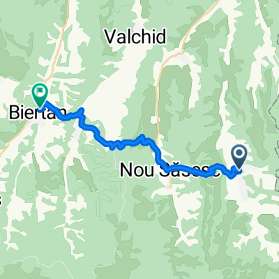
Urmaţi traseul cruce roşie pânǎ ȋn culmea Dealului Sneal. Faceţi dreapta pe marcajul bandǎ roşie şi urmaţi acest marcaj pentru aprox. 12 km, la ȋnceput pe un drum de cǎruţe apoi pe un drum pietruit iar la stâna de pe Dealul Fetea ieşiţi din nou de pe drumul pietruit. Imediat ce se terminǎ zona de pǎşunat veţi ȋntâlni la dreapta marcajul cruce roşie. Urmaţi acest drum care vǎ coboarǎ pe Valea Lacului pânǎ ȋn Copşa Mare. Ȋn centrul satului veţi intersecta marcajul bandǎ albastrǎ. Faceţi dreapta pe acest marcaj şi urcaţi uşor cǎtre un platou. Traversaţi acest platou, coborâţi pe Valea Lapşa şi apoi drumul urcǎ douǎ coame de deal pânǎ deasupra satului Nou Sǎsesc. Intraţi ȋn sat dinspre nord pe drumul asfaltat şi ȋn centru faceţi stânga cǎtre est. Drumul urcǎ uşor pânǎ la pǎdure, apoi urmeazǎ o scurtǎ porţiune abruptǎ pânǎ pe culmea dealului de unde coborâţi pe o pǎşune frumoasǎ ȋn Valea Haivale. Traversaţi firul apei şi urcaţi abrupt şi scurt pânǎ pe o hulǎ deasupra satului Mǎlâncrav. Coborâţi prin livadǎ şi pe lângǎ conacul Apafi. Traseul se suprapune parțial cu Via Transilvanica.
Ai parcurs acest traseu ? Dacă ai identificat probleme de acces (marcaje lipsă, deteriorate sau insuficient de clare, secțiuni impracticabile etc) sau ai sugestii pentru îmbunătățirea lor, te rugăm să ne scrii pe colineletransilvaniei@gmail.com. Nu uita să iei un punct GPS și câteva fotografii - ne va ajuta să intervenim mai repede pentru a remedia situația.
Follow the red cross track up to the top of the Sneal Hill. Turn right on the red strip marking and follow this marking for approximately 12 km, at first on a cart road, then on a pebbled road; at the sheepfold from the Petea Hill leave the pebbled road once again. As soon as the grasslands end, you will see the red cross marking on your right. Follow this road descending along the Lacului Valley all the way to Copşa Mare. In the centre of the village you will come across the blue strip marking. Turn right on this marking and climb easily towards a plateau. Cross this plateau, descend on the Lapşa Valley and then the road goes up two hill crests till it gets above the village of Nou Sǎsesc. Enter the village from the north on the asphalt road and in the centre turn left, going east. The road climbs gently to the forest, then comes a short abrupt sector until the top of the hill, wherefrom you will descend across a beautiful grassland in the Haivale Valley. Cross the water and take a steep, short climb to a landslide above the village of Mǎlâncrav. Descend through the orchard and past the Apafi mansion. The trail partially overlaps Via Transilvanica.
Did you travel this route? If you have identified access problems (missing, damaged or insufficiently clear markings, inaccessible sections etc.) or have suggestions for their improvement, please write to us at transylvanianhighlands@gmail.com. Don't forget to take a GPS point and a few photos - it will help us to intervene faster to fix the situation.
- -:--
- Dauer
- 38,8 km
- Distanz
- 1.021 m
- Aufstieg
- 1.021 m
- Abstieg
- ---
- Ø-Tempo
- 656 m
- Ø-Tempo

Weiter mit Bikemap
Diese Radroute verwenden, bearbeiten oder herunterladen
Du möchtest Colinele Transilvaniei: Circuit Mălâncrav - Dealul Fetea - Copșa Mare - Nou Săsesc - Mălâncrav fahren oder sie für deine eigene Reise anpassen? Folgendes kannst du mit dieser Bikemap-Route machen:
Gratis Funktionen
- Speichere diese Route als Favorit oder in einer Sammlung
- Kopiere & plane deine eigene Version dieser Route
- Synchronisiere deine Route mit Garmin oder Wahoo
Premium-Funktionen
Kostenlose Testversion für 3 Tage oder einmalige Zahlung. Mehr über Bikemap Premium.
- Navigiere diese Route auf iOS & Android
- Exportiere eine GPX / KML-Datei dieser Route
- Erstelle deinen individuellen Ausdruck (Jetzt kostenlos ausprobieren)
- Lade diese Route für die Offline-Navigation herunter
Entdecke weitere Premium-Funktionen.
Bikemap Premium aktivierenVon unserer Community
Mălâncrav: Andere beliebte Routen, die hier beginnen
 malancrav - culmea florestilor - floresti - laslea - roandola - nou sasesc - malancrav
- Distanz
- 30,5 km
- Aufstieg
- 427 m
- Abstieg
- 460 m
- Standort
- Mălâncrav, Hermannstadt, Rumänien
 Ziua 3 - Bisericile fortificate
- Distanz
- 69 km
- Aufstieg
- 754 m
- Abstieg
- 716 m
- Standort
- Mălâncrav, Hermannstadt, Rumänien
 1. Circuit din Mălâncrav
- Distanz
- 40,4 km
- Aufstieg
- 837 m
- Abstieg
- 837 m
- Standort
- Mălâncrav, Hermannstadt, Rumänien
 Malancrav - Biertan
- Distanz
- 15,4 km
- Aufstieg
- 479 m
- Abstieg
- 528 m
- Standort
- Mălâncrav, Hermannstadt, Rumänien
 Malancrav MTB 46 km Malancrav - Cris - Stejarenii - Dealul Fagetului - Zapodia Malancrav - Malancrav (ADE 16)
- Distanz
- 46,3 km
- Aufstieg
- 827 m
- Abstieg
- 829 m
- Standort
- Mălâncrav, Hermannstadt, Rumänien
 Colinele Transilvaniei: Circuit Mălâncrav - Dealul Fetea - Copșa Mare - Nou Săsesc - Mălâncrav
- Distanz
- 38,8 km
- Aufstieg
- 1.021 m
- Abstieg
- 1.021 m
- Standort
- Mălâncrav, Hermannstadt, Rumänien
 Floresti - Iacobeni
- Distanz
- 14,9 km
- Aufstieg
- 311 m
- Abstieg
- 103 m
- Standort
- Mălâncrav, Hermannstadt, Rumänien
 SZT - Keresd - rövid kör
- Distanz
- 32,3 km
- Aufstieg
- 461 m
- Abstieg
- 462 m
- Standort
- Mălâncrav, Hermannstadt, Rumänien
In der App öffnen