

Ride Day 16—26 Sept 2005—11500 Quillan - Circle
Eine Fahrradroute, die in Quillan, Occitanie, Frankreich beginnt.
Übersicht
Über diese Route
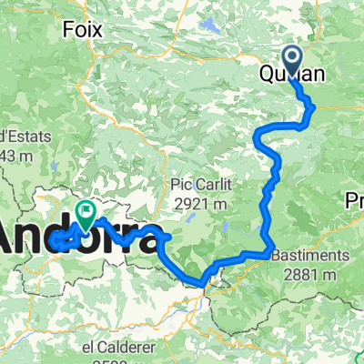
As we’d decided to remain in Quillan two nights and we had hope that the weather would get better, we started off on this circle ride with a wildly threatening sky and happily no panniers.
The day turned out glorious and my wife’s choice of roads was extraordinary. D117, while having too much traffic, was within a beautiful gorge called Défilé de Pierre-Lys. D107 climbed at mostly gentle grades along a very nice stream and had virtually no traffic. The scenery and views as we slowly climbed to the Plateau de Sault were outstanding as well. And there really was a flat area to justify this being called a plateau. The ride back down from our 896 M high point along D613 and D117 had many spectacular views of the Quillan valley and its surrounding mountains. The descent along D117 that we’d done in the relatively dark and rainy conditions yesterday was a real pleasure today.
Background:My wife and I have been doing self-supported tours in Western Europe (a majority in France) since 1993. This series of rides covers our 2005 2 month route through parts of France. Our beginning and ending point is near Chaduri (south of Angoulême) where our friends have a farm with Gites and Chambres d'Hotes.We rode our Dawes touring bicycles purchased in 1993 heavily loaded with 700Cx32 tires. All of our riding was on paved roads, mostly with very little traffic.If any questions, feel free to email me at jeffkadet@netdiving.comJeff
- -:--
- Dauer
- 60,1 km
- Distanz
- 747 m
- Aufstieg
- 748 m
- Abstieg
- ---
- Ø-Tempo
- ---
- Max. Höhe

Weiter mit Bikemap
Diese Radroute verwenden, bearbeiten oder herunterladen
Du möchtest Ride Day 16—26 Sept 2005—11500 Quillan - Circle fahren oder sie für deine eigene Reise anpassen? Folgendes kannst du mit dieser Bikemap-Route machen:
Gratis Funktionen
- Speichere diese Route als Favorit oder in einer Sammlung
- Kopiere & plane deine eigene Version dieser Route
- Synchronisiere deine Route mit Garmin oder Wahoo
Premium-Funktionen
Kostenlose Testversion für 3 Tage oder einmalige Zahlung. Mehr über Bikemap Premium.
- Navigiere diese Route auf iOS & Android
- Exportiere eine GPX / KML-Datei dieser Route
- Erstelle deinen individuellen Ausdruck (Jetzt kostenlos ausprobieren)
- Lade diese Route für die Offline-Navigation herunter
Entdecke weitere Premium-Funktionen.
Bikemap Premium aktivierenVon unserer Community
Quillan: Andere beliebte Routen, die hier beginnen
 VTT Pyrénées - circuit n°22
- Distanz
- 29,8 km
- Aufstieg
- 584 m
- Abstieg
- 584 m
- Standort
- Quillan, Occitanie, Frankreich
 Belvédère du Diable
- Distanz
- 7 km
- Aufstieg
- 442 m
- Abstieg
- 441 m
- Standort
- Quillan, Occitanie, Frankreich
 Quillan - Grandvalira Sector Carrillo
- Distanz
- 191,1 km
- Aufstieg
- 4.499 m
- Abstieg
- 2.756 m
- Standort
- Quillan, Occitanie, Frankreich
 2009 Entre-deux-mers - 2
- Distanz
- 259,7 km
- Aufstieg
- 79 m
- Abstieg
- 328 m
- Standort
- Quillan, Occitanie, Frankreich
 Ride Day 17—27 Sept 2005—11500 Quillan to 11350 Cucugnan
- Distanz
- 66,6 km
- Aufstieg
- 778 m
- Abstieg
- 790 m
- Standort
- Quillan, Occitanie, Frankreich
 Col de Jau
- Distanz
- 100,8 km
- Aufstieg
- 2.279 m
- Abstieg
- 2.279 m
- Standort
- Quillan, Occitanie, Frankreich
 Stage 4 - Cent Cols
- Distanz
- 118,6 km
- Aufstieg
- 2.625 m
- Abstieg
- 2.439 m
- Standort
- Quillan, Occitanie, Frankreich
 AAA Pyrenäen 2
- Distanz
- 94 km
- Aufstieg
- 2.426 m
- Abstieg
- 2.735 m
- Standort
- Quillan, Occitanie, Frankreich
In der App öffnen