
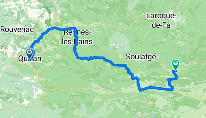
Ride Day 17—27 Sept 2005—11500 Quillan to 11350 Cucugnan
Eine Fahrradroute, die in Quillan, Languedoc-Roussillon-Midi-Pyrénées, France beginnt.
Übersicht
Über diese Route
With the exception of two major roads (D118 and D117), today’s ride was truly outstanding.
D14 climbed through a beautiful area that became somewhat arid by the Pic de Bugarach, which is a stunning sight from any angle. The Pic de Bugarach is 1230 M high and we passed by it at the Col du Linas at 680 M. This year, we were going west to east. Four years ago, we traveled this road from east to west.
D10/D17 took us through a beautiful gorge with the narrow road carved from the sides. Unbelievable road and wonderful sights. While on this road, we passed for the next several hours into the Pyrénées-Orientales Department before returning to Aude on D19/D123. This last road from Maury to Cucugnan was a beautiful climb above a valley surrounded by mountains. This climb took us to the Grau de Maury at 432 M where there is a road that goes further up to the Chateau de Quéribus. From the Grau de Maury, we descended directly to Cucugnan, which is set on a small hill within another huge valley surrounded by mountains. As with the Maury valley, there are plenty of vineyards.
Background:My wife and I have been doing self-supported tours in Western Europe (a majority in France) since 1993. This series of rides covers our 2005 2 month route through parts of France. Our beginning and ending point is near Chaduri (south of Angoulême) where our friends have a farm with Gites and Chambres d'Hotes.We rode our Dawes touring bicycles purchased in 1993 heavily loaded with 700Cx32 tires. All of our riding was on paved roads, mostly with very little traffic.If any questions, feel free to email me at jeffkadet@netdiving.comJeff
- -:--
- Dauer
- 66,6 km
- Distanz
- 778 m
- Aufstieg
- 790 m
- Abstieg
- ---
- Ø-Tempo
- ---
- Ø-Tempo

Weiter mit Bikemap
Diese Radroute verwenden, bearbeiten oder herunterladen
Du möchtest Ride Day 17—27 Sept 2005—11500 Quillan to 11350 Cucugnan fahren oder sie für deine eigene Reise anpassen? Folgendes kannst du mit dieser Bikemap-Route machen:
Gratis Funktionen
- Speichere diese Route als Favorit oder in einer Sammlung
- Kopiere & plane deine eigene Version dieser Route
- Synchronisiere deine Route mit Garmin oder Wahoo
Premium-Funktionen
Kostenlose Testversion für 3 Tage oder einmalige Zahlung. Mehr über Bikemap Premium.
- Navigiere diese Route auf iOS & Android
- Exportiere eine GPX / KML-Datei dieser Route
- Erstelle deinen individuellen Ausdruck (Jetzt kostenlos ausprobieren)
- Lade diese Route für die Offline-Navigation herunter
Entdecke weitere Premium-Funktionen.
Bikemap Premium aktivierenVon unserer Community
Quillan: Andere beliebte Routen, die hier beginnen
 2009 Entre-deux-mers - 2
- Distanz
- 259,7 km
- Aufstieg
- 79 m
- Abstieg
- 328 m
- Standort
- Quillan, Languedoc-Roussillon-Midi-Pyrénées, Frankreich
 Quillan - Grandvalira Sector Carrillo
- Distanz
- 191,1 km
- Aufstieg
- 4.499 m
- Abstieg
- 2.756 m
- Standort
- Quillan, Languedoc-Roussillon-Midi-Pyrénées, Frankreich
 Belvédère du Diable
- Distanz
- 7 km
- Aufstieg
- 442 m
- Abstieg
- 441 m
- Standort
- Quillan, Languedoc-Roussillon-Midi-Pyrénées, Frankreich
 Stage 4 - Cent Cols
- Distanz
- 118,6 km
- Aufstieg
- 2.625 m
- Abstieg
- 2.439 m
- Standort
- Quillan, Languedoc-Roussillon-Midi-Pyrénées, Frankreich
 etapa 2 - R
- Distanz
- 142,7 km
- Aufstieg
- 2.047 m
- Abstieg
- 1.940 m
- Standort
- Quillan, Languedoc-Roussillon-Midi-Pyrénées, Frankreich
 Couple of Cols Around Puivert
- Distanz
- 41,1 km
- Aufstieg
- 626 m
- Abstieg
- 628 m
- Standort
- Quillan, Languedoc-Roussillon-Midi-Pyrénées, Frankreich
 Col de Jau
- Distanz
- 100,8 km
- Aufstieg
- 2.279 m
- Abstieg
- 2.279 m
- Standort
- Quillan, Languedoc-Roussillon-Midi-Pyrénées, Frankreich
 Ride Day 17—27 Sept 2005—11500 Quillan to 11350 Cucugnan
- Distanz
- 66,6 km
- Aufstieg
- 778 m
- Abstieg
- 790 m
- Standort
- Quillan, Languedoc-Roussillon-Midi-Pyrénées, Frankreich
In der App öffnen