
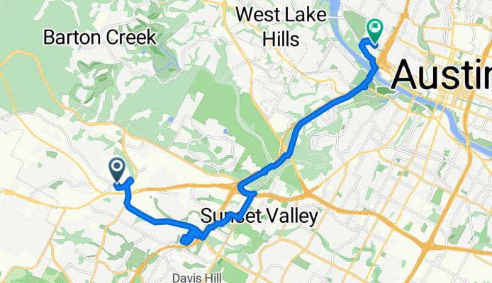
Austin - William Cannon Dr - Costco - Mopac Cycling Path
Eine Fahrradroute, die in Barton Creek, Texas, Vereinigte Staaten beginnt.
Übersicht
Über diese Route
Dies ist ein Abschnitt eines Kreises von der West 9th St. Leider ist die Bikemap-App während der Fahrt abgestürzt. Der fehlende Teil ist vom Ausgangspunkt West 9th St. entlang des Mopac-Radwegs bis zum Southwest Parkway. Dann weiter auf dem Southwest Parkway bis zur William Cannon Drive, wo wir nach Süden in Richtung Costco abgebogen sind.
Insgesamt eine schöne Fahrt, obwohl es viel Lärm vom Verkehr sowohl auf der Mopac als auch auf dem Southwest Parkway gibt. Außer für einen kleinen Abschnitt beim Auffahren auf den Southwest Parkway gab es einen ausgezeichneten breiten Fahrbahnrand bis zur Kreuzung mit der William Cannon Dr. Vom vorherigen Fahren auf dem Southwest Parkway weiß ich, dass der große Fahrbahnrand bis Highway 71 weitergeht.
Ein Teil des Weges, den wir benutzt haben, war unbefestigt. Es war jedoch hart und glatt, sodass es kein Problem für jedes Rennrad war. Wenn man diesen kurzen unbefestigten Abschnitt vermeiden möchte, könnte man einfach auf der South Mopac Service Road bleiben.
- 1 h 30 min
- Dauer
- 19,7 km
- Distanz
- 93 m
- Aufstieg
- 183 m
- Abstieg
- 13,2 km/h
- Ø-Tempo
- 262 m
- Max. Höhe

Fotos von der Route

Routenqualität
Wegtypen und Untergründe entlang der Route
Wegtypen
Radweg
5,7 km
(29 %)
Zufahrtsstraße
2,8 km
(14 %)
Untergründe
Befestigt
14 km
(71 %)
Unbefestigt
2,8 km
(14 %)
Asphalt
8,5 km
(43 %)
Beton
4,9 km
(25 %)
Weiter mit Bikemap
Diese Radroute verwenden, bearbeiten oder herunterladen
Du möchtest Austin - William Cannon Dr - Costco - Mopac Cycling Path fahren oder sie für deine eigene Reise anpassen? Folgendes kannst du mit dieser Bikemap-Route machen:
Gratis Funktionen
- Speichere diese Route als Favorit oder in einer Sammlung
- Kopiere & plane deine eigene Version dieser Route
- Synchronisiere deine Route mit Garmin oder Wahoo
Premium-Funktionen
Kostenlose Testversion für 3 Tage oder einmalige Zahlung. Mehr über Bikemap Premium.
- Navigiere diese Route auf iOS & Android
- Exportiere eine GPX / KML-Datei dieser Route
- Erstelle deinen individuellen Ausdruck (Jetzt kostenlos ausprobieren)
- Lade diese Route für die Offline-Navigation herunter
Entdecke weitere Premium-Funktionen.
Bikemap Premium aktivierenVon unserer Community
Barton Creek: Andere beliebte Routen, die hier beginnen
 Slow ride in Austin
- Distanz
- 44 km
- Aufstieg
- 358 m
- Abstieg
- 350 m
- Standort
- Barton Creek, Texas, Vereinigte Staaten
 5410 Wolf Run, Austin to 5409 Wolf Run, Austin
- Distanz
- 35,8 km
- Aufstieg
- 842 m
- Abstieg
- 842 m
- Standort
- Barton Creek, Texas, Vereinigte Staaten
 bike tour frggghhom Pastviny to Austin
- Distanz
- 25 km
- Aufstieg
- 323 m
- Abstieg
- 349 m
- Standort
- Barton Creek, Texas, Vereinigte Staaten
 Home route with Cuernavaca loop
- Distanz
- 38,9 km
- Aufstieg
- 778 m
- Abstieg
- 791 m
- Standort
- Barton Creek, Texas, Vereinigte Staaten
- Austin - William Cannon Dr - Costco - Mopac Cycling Path
- Distanz
- 19,7 km
- Aufstieg
- 93 m
- Abstieg
- 183 m
- Standort
- Barton Creek, Texas, Vereinigte Staaten
 Fitzhugh Rd Loop
- Distanz
- 69 km
- Aufstieg
- 386 m
- Abstieg
- 385 m
- Standort
- Barton Creek, Texas, Vereinigte Staaten
 Driftwood Loop
- Distanz
- 87,5 km
- Aufstieg
- 449 m
- Abstieg
- 453 m
- Standort
- Barton Creek, Texas, Vereinigte Staaten
 Restful route in Austin
- Distanz
- 19,8 km
- Aufstieg
- 93 m
- Abstieg
- 148 m
- Standort
- Barton Creek, Texas, Vereinigte Staaten
In der App öffnen