Premium Badge Aus dem App Store herunterladen Hol dir Bikemap auf Google Play Turn-by-Turn-Navigation Offline Maps Bike Type Optimized Routing Premium Maps Individueller Fahrradcomputer Routen-Export Route Previews Sturzerkennung Premium Support

Radroute in Chiang Mai, Chiang Mai Province, Thailand
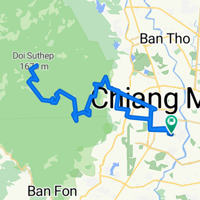
Epic Suthep XC ride

9
Route in der Bikemap App öffnen

Route in der Bikemap App öffnen

Diese Route in Bikemap Web öffnen

Diese Route in Bikemap Web öffnen

50 km
Distanz
1351 m
Aufstieg
1370 m
Abstieg
-:-- h
Dauer
-- km/h
ø-Tempo
--- m
Max. Höhe

Über diese Route

This is a full-day cross country ride on the south side of Doi Suthep / Doi Pui with 50% offroad mountain trails that has it all: <span id=".reactRoot[16].[1][4][1]{comment654563254560358_105872954}.0.[1].0.[1].0.[0].[0][2]"><span id=".reactRoot[16].[1][4][1]{comment654563254560358_105872954}.0.[1].0.[1].0.[0].[0][2].0"><span id=".reactRoot[16].[1][4][1]{comment654563254560358_105872954}.0.[1].0.[1].0.[0].[0][2].0.[0]">steep climbs, steep downhill, single track, flowy sections, double track, forest, orchards, stream crossings, viewpoints, and hill tribes.</span></span></span>

You begin by climbing Doi Suthep via Sriwichai Rd. all the way to the fork where the road leads down to Ban Hmong Doi Pui. To make this less strenuous, you can take a songthaeo/taxi to Ban Hmong Doi Pui. Continue straight through the Hmong village to the gardens, but instead of going into the gardens, take the path above it which passes a waterfall. At the next fork, take the right path. This path first falls down north and then climbs another 200m while making a south turn. From there you ride 500m down along a ridge and then follow the track through valleys and orchards all the way to Ban Pong where you hit Rd. 1269.

You can continue on Rd. 1269 to go back to Chiang Mai, but a more interesting option is to take the back roads leading through the foot hills (about 100m final climb) around the Doi Kham area, as shown in the route.

Diese Fahrradroute ist ideal für: MTB

Du fährst auf folgendem Untergrund: Asphaltiert Unbefestigt

Passe diese Fahrradroute mit dem Bikemap-Routenplaner an.

Passe diese Route an!

Wusstest du schon? Du kannst diese Route als Vorlage in unserem Routenplaner verwenden, und sie ganz einfach nach deinen Bedürfnissen anpassen. So planst du noch schneller deine perfekte Radtour.

In der App öffnen