

Tour de Winooski
Eine Fahrradroute, die in Winooski, Vermont, United States of America beginnt.
Übersicht
Über diese Route
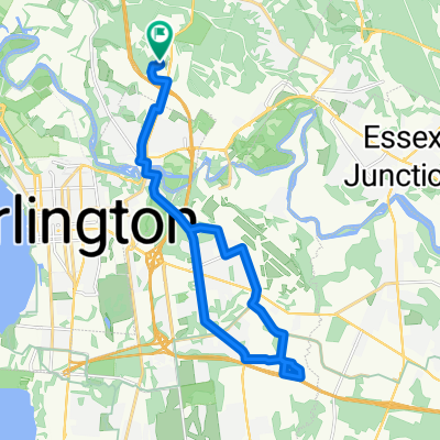
The Tour de Winooski is a proposed self-guided biking tour that begins at the Intervale Center. This community farming center is a resource for locally grown and locally operated food production in the Burlington area, and is in close proximity to signs of geological history at the next stop on the tour, Salmon Hole. This natural area on the Winooski River is an important habitat for riparian fish species and shows its geological history through the dolostone outcrops it is home to. The next location on the bike tour is the Ben and Jerry’s factory in Waterbury, VT. This is a local food production factory that is loved by many Vermonters and people around the world. Before bikers reach Waterbury, they will bike past Mt. Mansfield, which is the highest mountain peak in Vermont. The next stop on the tour is Hubbard Tower in Montpelier. Bikers can climb the observation tower and observe the geology of the Winooski Watershed through the views of the Green Mountains around them. If they are tired, bikers can spend the night at one of multiple locally-owned bed and breakfasts in Montpelier. In the morning, bikers will follow the tour to Barre. They can pick up some groceries and think about geology at Granite City Grocery, the grocery co-op in Barre. At this point in the bike tour, it is time to turn around. Bikers will follow the tour on a long haul back to Burlington, where they can enjoy local food from a variety of restaurants and rest at the Burlington Hostel.
- -:--
- Dauer
- 165,6 km
- Distanz
- 549 m
- Aufstieg
- 525 m
- Abstieg
- ---
- Ø-Tempo
- ---
- Ø-Tempo

Routenqualität
Wegtypen und Untergründe entlang der Route
Wegtypen
Straße
65,6 km
(40 %)
Vielbefahrene Straße
49,4 km
(30 %)
Untergründe
Befestigt
125,3 km
(76 %)
Unbefestigt
35,2 km
(21 %)
Asphalt
120,3 km
(73 %)
Schotter
27,2 km
(16 %)
Weiter mit Bikemap
Diese Radroute verwenden, bearbeiten oder herunterladen
Du möchtest Tour de Winooski fahren oder sie für deine eigene Reise anpassen? Folgendes kannst du mit dieser Bikemap-Route machen:
Gratis Funktionen
- Speichere diese Route als Favorit oder in einer Sammlung
- Kopiere & plane deine eigene Version dieser Route
- Synchronisiere deine Route mit Garmin oder Wahoo
Premium-Funktionen
Kostenlose Testversion für 3 Tage oder einmalige Zahlung. Mehr über Bikemap Premium.
- Navigiere diese Route auf iOS & Android
- Exportiere eine GPX / KML-Datei dieser Route
- Erstelle deinen individuellen Ausdruck (Jetzt kostenlos ausprobieren)
- Lade diese Route für die Offline-Navigation herunter
Entdecke weitere Premium-Funktionen.
Bikemap Premium aktivierenVon unserer Community
Winooski: Andere beliebte Routen, die hier beginnen
 Sporty route in Essex Junction
- Distanz
- 13,9 km
- Aufstieg
- 147 m
- Abstieg
- 103 m
- Standort
- Winooski, Vermont, USA
 Tour de Winooski
- Distanz
- 165,6 km
- Aufstieg
- 549 m
- Abstieg
- 525 m
- Standort
- Winooski, Vermont, USA
 Whale Tails
- Distanz
- 31,9 km
- Aufstieg
- 184 m
- Abstieg
- 184 m
- Standort
- Winooski, Vermont, USA
 12 Winooski Falls Way, Winooski to Island Line Trail, Burlington
- Distanz
- 5,2 km
- Aufstieg
- 120 m
- Abstieg
- 104 m
- Standort
- Winooski, Vermont, USA
 54 Russell St, Winooski to Island Line Trail, Burlington
- Distanz
- 7,3 km
- Aufstieg
- 59 m
- Abstieg
- 97 m
- Standort
- Winooski, Vermont, USA
 Work
Work- Distanz
- 4,1 km
- Aufstieg
- 56 m
- Abstieg
- 5 m
- Standort
- Winooski, Vermont, USA
 flat loop around colchester
- Distanz
- 21,3 km
- Aufstieg
- 158 m
- Abstieg
- 152 m
- Standort
- Winooski, Vermont, USA
 Burlington city route
- Distanz
- 26,2 km
- Aufstieg
- 229 m
- Abstieg
- 229 m
- Standort
- Winooski, Vermont, USA
In der App öffnen