
Gol round 1
Eine Fahrradroute, die in Gol, Buskerud, Norwegen beginnt.
Übersicht
Über diese Route
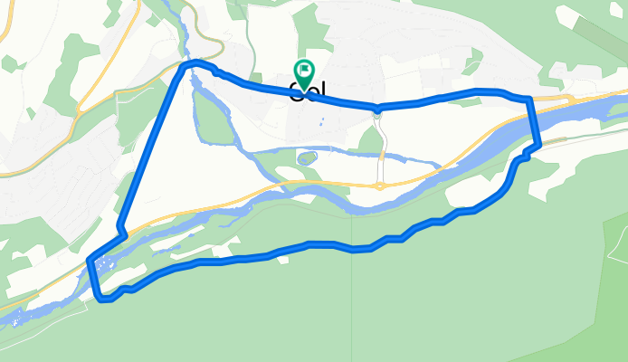
Fahren Sie durch das Stadtzentrum und folgen Sie dem Fußweg in Richtung der Autobahn Rv 7. Überqueren Sie die Rv 7 und dann die Moen-Brücke, um auf die andere Seite des Hallingdal-Flusses zu gelangen. Gehen Sie nach dem Unterführungsdurchgang links und folgen Sie der Straße in Richtung des Bahnhofs Gol. Ein langer, aber nicht sehr steiler Anstieg bringt Sie zu einem Aussichtspunkt mit Bänken. Die Hügel hinunter zum Gol Motor og Fritidssenter können herausfordernd sein, daher ist es am besten, langsam zu fahren. Folgen Sie der Straße vom Gol Motor og Fritidssenter zum Bahnhof. Überqueren Sie den Fluss auf der linken Brücke und folgen Sie der Sentrumsvegen zurück ins Stadtzentrum.
- -:--
- Dauer
- 6,3 km
- Distanz
- 351 m
- Aufstieg
- 351 m
- Abstieg
- ---
- Ø-Tempo
- ---
- Max. Höhe

Routenqualität
Wegtypen und Untergründe entlang der Route
Wegtypen
Zufahrtsstraße
2,3 km
(36 %)
Straße
1,6 km
(26 %)
Untergründe
Befestigt
1,4 km
(22 %)
Unbefestigt
2,1 km
(33 %)
Schotter
2,1 km
(33 %)
Asphalt
1,4 km
(22 %)
Undefiniert
2,9 km
(45 %)
Weiter mit Bikemap
Diese Radroute verwenden, bearbeiten oder herunterladen
Du möchtest Gol round 1 fahren oder sie für deine eigene Reise anpassen? Folgendes kannst du mit dieser Bikemap-Route machen:
Gratis Funktionen
- Speichere diese Route als Favorit oder in einer Sammlung
- Kopiere & plane deine eigene Version dieser Route
- Synchronisiere deine Route mit Garmin oder Wahoo
Premium-Funktionen
Kostenlose Testversion für 3 Tage oder einmalige Zahlung. Mehr über Bikemap Premium.
- Navigiere diese Route auf iOS & Android
- Exportiere eine GPX / KML-Datei dieser Route
- Erstelle deinen individuellen Ausdruck (Jetzt kostenlos ausprobieren)
- Lade diese Route für die Offline-Navigation herunter
Entdecke weitere Premium-Funktionen.
Bikemap Premium aktivierenVon unserer Community
Gol: Andere beliebte Routen, die hier beginnen
 Golsfjellet Tisleidalen
- Distanz
- 69,4 km
- Aufstieg
- 881 m
- Abstieg
- 881 m
- Standort
- Gol, Buskerud, Norwegen
 Golsfjellet
- Distanz
- 69,3 km
- Aufstieg
- 1.019 m
- Abstieg
- 973 m
- Standort
- Gol, Buskerud, Norwegen
 Garnos route
- Distanz
- 47,6 km
- Aufstieg
- 1.462 m
- Abstieg
- 1.462 m
- Standort
- Gol, Buskerud, Norwegen
 Golsfjellet - Vinstervannet - Tyin - Golsfjellet
- Distanz
- 269,1 km
- Aufstieg
- 4.077 m
- Abstieg
- 4.076 m
- Standort
- Gol, Buskerud, Norwegen
 The Waffle Tour 2 CLONED FROM ROUTE 496988
- Distanz
- 51,1 km
- Aufstieg
- 599 m
- Abstieg
- 598 m
- Standort
- Gol, Buskerud, Norwegen
 Gol round 1
- Distanz
- 6,3 km
- Aufstieg
- 351 m
- Abstieg
- 351 m
- Standort
- Gol, Buskerud, Norwegen
 Storefjellrunden
- Distanz
- 9,5 km
- Aufstieg
- 417 m
- Abstieg
- 420 m
- Standort
- Gol, Buskerud, Norwegen
 Einarsetrunden 14km
- Distanz
- 13,8 km
- Aufstieg
- 256 m
- Abstieg
- 261 m
- Standort
- Gol, Buskerud, Norwegen
In der App öffnen