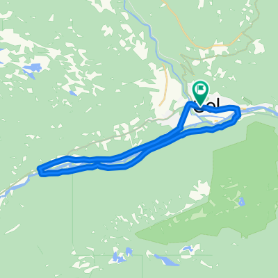
Hallingrittet
- 42,2 km
- 746 m
- 746 m
- Gol, Buskerud, Norwegen
Eine Fahrradroute, die in Gol, Buskerud, Norwegen beginnt.
Übersicht
<span style="color: #000000; font-family: verdana, arial, helvetica, sans-serif; font-size: 11px; line-height: 16px; -webkit-border-horizontal-spacing: 4px; -webkit-border-vertical-spacing: 4px;">Round trip of Golsfjellet (app. 40km)<br style="font: normal normal normal 11px/1.5em verdana, arial, helvetica, sans-serif; color: #000000; line-height: 0.8em;" /><br style="font: normal normal normal 11px/1.5em verdana, arial, helvetica, sans-serif; color: #000000; line-height: 0.8em;" />This round trip is for all ages, and it will give you a great view of the nearby mountain areas!<br style="font: normal normal normal 11px/1.5em verdana, arial, helvetica, sans-serif; color: #000000; line-height: 0.8em;" /><br style="font: normal normal normal 11px/1.5em verdana, arial, helvetica, sans-serif; color: #000000; line-height: 0.8em;" />Start at Oset Høyfjellshotell. Follow the road to Guriset, but take off midway through the inclines and follow the dirt road through Stølsdokki and Appelsintreet. Over Flæin you'll ride along an old tractor road (Gamle Gurisetvegen) to lake Lauvsjøen. <br style="font: normal normal normal 11px/1.5em verdana, arial, helvetica, sans-serif; color: #000000; line-height: 0.8em;" /><br style="font: normal normal normal 11px/1.5em verdana, arial, helvetica, sans-serif; color: #000000; line-height: 0.8em;" />The stretch over Flæin is of good quality, but not well suited for the very youngest cyclists or bike trailers. During rainy periods there will be some moisture in parts of the route.<br style="font: normal normal normal 11px/1.5em verdana, arial, helvetica, sans-serif; color: #000000; line-height: 0.8em;" /><br style="font: normal normal normal 11px/1.5em verdana, arial, helvetica, sans-serif; color: #000000; line-height: 0.8em;" />Make a left turn and follow the main road to Lauvset where you make another left and follow the farm road past Fiskedammen pond, Tunnetjern pond and to Vermelie.<br style="font: normal normal normal 11px/1.5em verdana, arial, helvetica, sans-serif; color: #000000; line-height: 0.8em;" /><br style="font: normal normal normal 11px/1.5em verdana, arial, helvetica, sans-serif; color: #000000; line-height: 0.8em;" />Then go app 500 m of tractor road to Skutuset and on to Storefjell. Ride around and behind the hotel, follow the road past Kamben Høyfjellshotell and back to the main road (Fjellheimvegen).<br style="font: normal normal normal 11px/1.5em verdana, arial, helvetica, sans-serif; color: #000000; line-height: 0.8em;" /><br style="font: normal normal normal 11px/1.5em verdana, arial, helvetica, sans-serif; color: #000000; line-height: 0.8em;" />Follow this road to the left until you get back to Oset Høyfjellshotell.<br style="font: normal normal normal 11px/1.5em verdana, arial, helvetica, sans-serif; color: #000000; line-height: 0.8em;" /></span>
Erstellt vor 15 Jahren
Routenqualität
Ruhige Straße
30,4 km
(99 %)
Zufahrtsstraße
0,3 km
(1 %)
Unbefestigt
28,6 km
(93 %)
Schotter
27,4 km
(89 %)
Loser Schotter
1,2 km
(4 %)
Undefiniert
2,2 km
(7 %)
Weiter mit Bikemap
Du möchtest Golsfjellet rundt fahren oder sie für deine eigene Reise anpassen? Folgendes kannst du mit dieser Bikemap-Route machen:
Kostenlose Testversion für 3 Tage oder einmalige Zahlung. Mehr über Bikemap Premium.
Entdecke weitere Premium-Funktionen.
Bikemap Premium aktivierenVon unserer Community
In der App öffnen