

2019-32 Montauban to Colomiers (Toulouse)
Eine Fahrradroute, die in Montauban, Occitanie, Frankreich beginnt.
Übersicht
Über diese Route
<p>Im Jahr 2019 machten wir self-supported Touring für etwas weniger als 2 Monate von Mitte September bis Anfang November.</p>
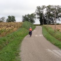
<p>Tag 32 - Montauban nach Colomiers (Toulouse)</p>
<p>Das war unser letzter Tag auf dem Rad, bevor wir zurück in die USA flogen. Frankreich gab uns einen guten Abschied mit heftigem Regen während dieser letzten Fahrt.</p>
<p>Die D21 war ausgezeichnet mit wenig Verkehr. Die D14 hatte zwar etwas mehr Verkehr, war jedoch nicht schlecht, wenn man schnell ans Ziel kommen wollte, anstatt kleinere Straßen zu benutzen, die nicht so direkt sind.</p>
<p>Ein Teil des Radwegs nach Blagnac und Colomiers war unbefestigt. Es war jedoch nicht schlecht, selbst im Regen.</p>
<p>Bei all dem Regen habe ich keine Bilder gemacht. Ich habe das Titelbild der Hängebrücke über den Tarn in Villebumier aus dem Internet genommen.</p>
<p>Ein großartiger Abschluss einer wunderbaren Zeit in Frankreich.</p>
Übersetzt, Original anzeigen (Englisch)- -:--
- Dauer
- 65,9 km
- Distanz
- 221 m
- Aufstieg
- 194 m
- Abstieg
- ---
- Ø-Tempo
- ---
- Max. Höhe

Routenqualität
Wegtypen und Untergründe entlang der Route
Wegtypen
Ruhige Straße
13,2 km
(20 %)
Radweg
4,6 km
(7 %)
Untergründe
Befestigt
19,1 km
(29 %)
Unbefestigt
0,7 km
(1 %)
Asphalt
19,1 km
(29 %)
Schotter
0,7 km
(1 %)
Undefiniert
46,1 km
(70 %)
Weiter mit Bikemap
Diese Radroute verwenden, bearbeiten oder herunterladen
Du möchtest 2019-32 Montauban to Colomiers (Toulouse) fahren oder sie für deine eigene Reise anpassen? Folgendes kannst du mit dieser Bikemap-Route machen:
Gratis Funktionen
- Speichere diese Route als Favorit oder in einer Sammlung
- Kopiere & plane deine eigene Version dieser Route
- Synchronisiere deine Route mit Garmin oder Wahoo
Premium-Funktionen
Kostenlose Testversion für 3 Tage oder einmalige Zahlung. Mehr über Bikemap Premium.
- Navigiere diese Route auf iOS & Android
- Exportiere eine GPX / KML-Datei dieser Route
- Erstelle deinen individuellen Ausdruck (Jetzt kostenlos ausprobieren)
- Lade diese Route für die Offline-Navigation herunter
Entdecke weitere Premium-Funktionen.
Bikemap Premium aktivierenVon unserer Community
Montauban: Andere beliebte Routen, die hier beginnen
 2016 Ride Day 115 - Montauban to Auch
- Distanz
- 110,7 km
- Aufstieg
- 686 m
- Abstieg
- 685 m
- Standort
- Montauban, Occitanie, Frankreich
 Montauban to Cahors
- Distanz
- 69 km
- Aufstieg
- 686 m
- Abstieg
- 739 m
- Standort
- Montauban, Occitanie, Frankreich
 BVCC Montauban to Carcassonne 3
- Distanz
- 149 km
- Aufstieg
- 450 m
- Abstieg
- 412 m
- Standort
- Montauban, Occitanie, Frankreich
 2019-32 Montauban to Colomiers (Toulouse)
- Distanz
- 65,9 km
- Aufstieg
- 221 m
- Abstieg
- 194 m
- Standort
- Montauban, Occitanie, Frankreich
 2016 Ride Day 170 - Montauban to Auch
- Distanz
- 93,6 km
- Aufstieg
- 418 m
- Abstieg
- 419 m
- Standort
- Montauban, Occitanie, Frankreich
 Montauban to St-Etienne-de-Tulmont_Plus Side Trip by McDonalds
- Distanz
- 29,1 km
- Aufstieg
- 113 m
- Abstieg
- 114 m
- Standort
- Montauban, Occitanie, Frankreich
 Montauban - Circle toward Nègrepelisse
- Distanz
- 40,7 km
- Aufstieg
- 291 m
- Abstieg
- 292 m
- Standort
- Montauban, Occitanie, Frankreich
 BVCC Montauban to Carcassonne
- Distanz
- 148 km
- Aufstieg
- 461 m
- Abstieg
- 409 m
- Standort
- Montauban, Occitanie, Frankreich
In der App öffnen