

Road cycling. Val d'Aran - Pyrenees: Tour Vielha with Superbagneres
Eine Fahrradroute, die in Les, Katalonien, Spanien beginnt.
Übersicht
Über diese Route
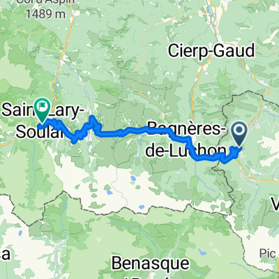
Diese Route beginnt in Bossòst, könnte aber ebenso gut für Radfahrer dienen, die in Vielha bleiben und Bossòst entlang der breiten Schultern der N-230 erreichen könnten.
Wir starten in Bossòst und verlassen die Stadt von Süden her entlang des Flusses Garona, biegen am Kreisverkehr rechts auf die N-141 bergauf ab. Dies ist der Beginn des Portilhon, des Passes, der die Grenze zwischen Spanien und Frankreich markiert. Der Anstieg beginnt mit einer Reihe von Haarnadelkurven, die großartige Ausblicke zurück auf Bossòst bieten, führt am Aran Park vorbei und nach Überqueren der Grenze am Gipfel schnell hinunter nach Frankreich.
In Saint-Mamet, wenn du gut in Form bist, folge der GPS-Spur nach links, nachdem du den Fluss Pique überquert hast, um zum Aufstieg nach Superbagnères zu gelangen. Dieser Anstieg endet im Nirgendwo, du wirst also bis zum Gipfel fahren und an diesen Punkt zurückkehren. Wenn du ihn auslassen möchtest, biege nach der Flussüberquerung rechts ab und fahre weiter durch Bagnères de Luchon.
Wenn du zu Superbagnères aufsteigst, wird es gleich nach Saint-Mamet steil mit Rampen von bis zu 12 % innerhalb der ersten zwei Kilometer. Die Gesamtlänge des Anstiegs beträgt 18,5 Kilometer und richtet sich an erfahrene Radfahrer. Der Höhengewinn beträgt 1170 m, was dich auf über 1800 m Höhe bringt, mit einer durchschnittlichen Steigung von 6,3 %. Du verlässt schließlich die Baumgrenze, und die Landschaft öffnet sich zu weiten, hochgelegenen Weiden mit Ausblicken auf viele der 3000 m hohen schneebedeckten Gipfel der Region. Oben an der Skistation angekommen, bleibt nur noch die Umkehr und die Abfahrt zurück nach Bagnères-de-Luchon.
Die Route führt nun von Süden nach Norden durch Bagnères-de-Luchon, folgt dem Fluss Pique entlang der D125 bis Gaud, wo wir am Kreisverkehr rechts abbiegen und auf die D44 Richtung Marignac wechseln. Die D44 ist eine relativ einfache Straße, die nach Marignac sanft ansteigt. Wir erreichen das Tal der Garonne und biegen rechts auf die N125 ab, die entlang des Flusstals leicht weiter ansteigt bis zur spanischen Grenze.
Interessante Punkte: Der Anstieg nach Superbagnères ist eine Pilgerfahrt für Tour-de-France-Fans, die hier viele berühmte Duelle der weltbesten Radprofis erlebt haben. Es ist sehr wild, und es gibt schöne Ausblicke (und Geräusche) des herunterstürzenden Flusses Lys neben der Straße entlang der Route.
- -:--
- Dauer
- 90,2 km
- Distanz
- 2.386 m
- Aufstieg
- 2.386 m
- Abstieg
- ---
- Ø-Tempo
- ---
- Max. Höhe

Routenqualität
Wegtypen und Untergründe entlang der Route
Wegtypen
Straße
33,4 km
(37 %)
Ruhige Straße
1,8 km
(2 %)
Untergründe
Befestigt
46,9 km
(52 %)
Asphalt
46,9 km
(52 %)
Undefiniert
43,3 km
(48 %)
Weiter mit Bikemap
Diese Radroute verwenden, bearbeiten oder herunterladen
Du möchtest Road cycling. Val d'Aran - Pyrenees: Tour Vielha with Superbagneres fahren oder sie für deine eigene Reise anpassen? Folgendes kannst du mit dieser Bikemap-Route machen:
Gratis Funktionen
- Speichere diese Route als Favorit oder in einer Sammlung
- Kopiere & plane deine eigene Version dieser Route
- Teile sie in Etappen ein, um eine mehrtägige Tour zu erstellen
- Synchronisiere deine Route mit Garmin oder Wahoo
Premium-Funktionen
Kostenlose Testversion für 3 Tage oder einmalige Zahlung. Mehr über Bikemap Premium.
- Navigiere diese Route auf iOS & Android
- Exportiere eine GPX / KML-Datei dieser Route
- Erstelle deinen individuellen Ausdruck (Jetzt kostenlos ausprobieren)
- Lade diese Route für die Offline-Navigation herunter
Entdecke weitere Premium-Funktionen.
Bikemap Premium aktivierenVon unserer Community
Les: Andere beliebte Routen, die hier beginnen
 Road cycling. Val d'Aran - Pyrenees: Tour Vielha with Superbagneres
- Distanz
- 90,2 km
- Aufstieg
- 2.386 m
- Abstieg
- 2.386 m
- Standort
- Les, Katalonien, Spanien
 Bossost 2
- Distanz
- 115 km
- Aufstieg
- 2.516 m
- Abstieg
- 2.512 m
- Standort
- Les, Katalonien, Spanien
 Bossot-Portillon-Peyragudes-Val Louron-Saint Lary Soulan
- Distanz
- 62,4 km
- Aufstieg
- 2.168 m
- Abstieg
- 2.057 m
- Standort
- Les, Katalonien, Spanien
 Bossost 2
- Distanz
- 134,3 km
- Aufstieg
- 2.863 m
- Abstieg
- 2.866 m
- Standort
- Les, Katalonien, Spanien
 1 Luchon
- Distanz
- 156,8 km
- Aufstieg
- 2.652 m
- Abstieg
- 2.764 m
- Standort
- Les, Katalonien, Spanien
 PIRINEOS MÍTICOS 2020
- Distanz
- 386,7 km
- Aufstieg
- 14.434 m
- Abstieg
- 14.347 m
- Standort
- Les, Katalonien, Spanien
 Road Cycling: Aran - Haute Garonne Loop
- Distanz
- 136,4 km
- Aufstieg
- 4.122 m
- Abstieg
- 4.121 m
- Standort
- Les, Katalonien, Spanien
 waypoint puertos pirineos
- Distanz
- 51,7 km
- Aufstieg
- 1.322 m
- Abstieg
- 981 m
- Standort
- Les, Katalonien, Spanien
In der App öffnen